
| Reference: | S35995.39 |
| Author | Pierre DUVAL |
| Year: | 1656 ca. |
| Zone: | Poland |
| Printed: | Paris |
| Measures: | 120 x 100 mm |
| Reference: | S35995.39 |
| Author | Pierre DUVAL |
| Year: | 1656 ca. |
| Zone: | Poland |
| Printed: | Paris |
| Measures: | 120 x 100 mm |
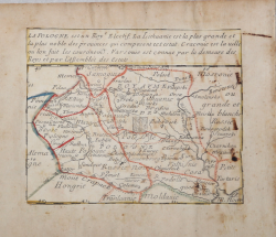
Etching, circa 1656, with contemporary outline colour, good condition.
Example of the second state, with the imprint of Jacques Lagniet and the date 1661.
The map comes from the very rare sheet entitled “L’Europe Par le Sieur Du Val Geographe Ord. du Roy”, from which it was cut at the time and laid down on contemporary laid paper support, to form a small atlas, as certified by the ancient ink inscriptions on some of the maps.
We have not found bibliography on this sheet of Europe, we therefore refer to the scarce literature on the sheets representing the other continents.
According with Philip Burden “The purpose of this rare curiosity by Pierre Duval is not known. It forms part of a set of the four known continents. It can be dated to apporximately 1656 […] The second state bears the additional imprint of Jacques Lagniet and the date 1661” (cf. Burden, The Mapping of North America, pp. 417-418, n. 322).
The map of Asia is recently described by Jason Hubbard: “This miniature map of Japan is on a sheet of maps of Asia. Besides the map of the Asian continent there are 17 detailed maps including Turkey, the Holy Land, Georgia and Arabia. […] This map was issued as a loose sheet of Asia maps; similar maps are known for Africa, America and Europe” (cf. Japoniae Insulae, The Mapping of Japan, p. 201).
Richard Betz describes 3 states of the broadsheet of Africa: without the date, with the imprint of Jacques Lagniet and the date 1661, and with traces of erasure on his addres (cf. Betz, The Mapping of Africa, pp. 294, 295). According Hubbard the third state of the map of Asia is only an assumption.
Of a second state of the broadsheet of Europe, we are able to find only the example at the Bibliotheque National de France.
|
cf. J. Hubbard, Japoniae Insulae. The Mapping of Japan, pp. 199-201, n. 28; cf. Burden, The Mapping of America, n. 322, II/II; cf. Pastoureau (1984) p. 136; cf. Betz, The Mapping of Africa, pp. 294, 295, n. 85.
|
Pierre DUVAL(1618 - 1683)
|
cf. J. Hubbard, Japoniae Insulae. The Mapping of Japan, pp. 199-201, n. 28; cf. Burden, The Mapping of America, n. 322, II/II; cf. Pastoureau (1984) p. 136; cf. Betz, The Mapping of Africa, pp. 294, 295, n. 85.
|
Pierre DUVAL(1618 - 1683)