

| Reference: | S49238.80 |
| Author | Georg BRAUN & Franz HOGENBERG |
| Year: | 1617 |
| Zone: | Kalwarya Zebrzydowska |
| Printed: | Antwerpen & Cologne |
| Measures: | 455 x 350 mm |
| Reference: | S49238.80 |
| Author | Georg BRAUN & Franz HOGENBERG |
| Year: | 1617 |
| Zone: | Kalwarya Zebrzydowska |
| Printed: | Antwerpen & Cologne |
| Measures: | 455 x 350 mm |
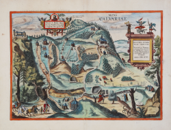
Bird-eye view plan of Kalwarya Zebrzydowska (southeast of Krakow), first published in the sixth volume of Civitates Orbis Terrarum, edited in 1617.
This panoramic view from the north shows pilgrims on their way to Kalwaria Zebrzydowska, a famous place of pilgrimage southwest of Cracow. In the years 1600-1604, Mikolaj Zebrzydowski, the Voivode of Cracow, inspired by the descriptions of Jerusalem by Christian Adrian Cruys, ordered the reconstruction and renaming of the region around Mount Zarek, modelled as accurately as possible on the actual topography of Jerusalem, even in respect of correct distances.Commentary by Braun on verso:
“How much more praiseworthy are they who have a deep desire to see the places where our Lord and saviour died for our salvation. But since not everyone can visit those places personally and see them with their own eyes, that noble hero Mr Mikolaj Zebrzydowski of Zebrzidovicz discovered a place about four miles away from Cracow and found that it matched in almost every way the Hill of Calvary in the Holy Land and other nearby places. He then had it divided and drawn up so that the most important stations of the bitter Passion and death of Christ, as well as other stories mentioned in the Holy Scriptures, could be imagined at the corresponding places [...], just as if one were in Jerusalem."
This view comes from the sixth and last volume of the 'Civitates Orbis Terrarum' ("Theatri Praecipuarum Totius Mundi Urbivm Liber Sextus"), published in a much smaller edition than previous volumes, and it is, therefore, rarer than most of Braun & Hogenberg city views, published by A. Hierat in Cologne, 1618.
The first volume of the Civitates Orbis Terrarum was published in Cologne in 1572. The sixth and the final volume appeared in 1617. This great city atlas, edited by Georg Braun and largely engraved by Franz Hogenberg, eventually contained 546 prospects, bird-eye views and map views of cities from all over the world. Fransz Hogenberg produced the plates for the first four books, and Simon van den Neuwel (Novellanus, active since 1580) those for volumes V and VI.
Georg Braun (1541-1622), a cleric of Cologne, was the principal editor of the work, and was greatly assisted in his project by the close, and continued interest of Abraham Ortelius, whose Theatrum Orbis Terrarum of 1570 was, as a systematic and comprehensive collection of maps of uniform style, the first true atlas. The Civitates, indeed, was intended as a companion for the Theatrum, as indicated by the similarity in the titles and by contemporary references regarding the complementary nature of two works. Nevertheless, the Civitates was designs to be more popular in approach, no doubt because the novelty of a collection of city plans and views represented a more hazardous commercial undertaking than a world atlas, for which there had been a number of successful precedents. Franz Hogenberg (1535-1590) was the son of a Munich engraves who settled in Malines. He engraved most of the plates for Ortelius's Theatrum and the majority of those in the Civitates and may have been responsible for originating the project.
Over a hundred of different artists and cartographers, the most significant of whom was Antwerp artist Georg Hoefnagel (1542-1600), engraved the cooper-plates of the Civitates from drawings. He not only contributed most of the original material for the Spanish and Italian towns but also reworked and modified those of other contributors. After Hoefnagel's death his son Jakob continued the work for the Civitates.
The author set out to depict "non icones et typi urbium," that is, not generic and typified images, "sed urbes ipsae admirabili caelaturae artificio, spectantium oculis subiectae appareant": not intended to allude or idealize but to represent faithfully on paper, to reproduce exactly, and in real time, what the eye sees, as announced in the preface to the first volume of Civitates Orbis Terrarum.
Copperplate engraving with fine hand colour, in very good condition.
Bibliografia
Van der Krogt 41:1.6.
|
George Braun (1541-1622), cleric of Cologne, was the principal editor of the Civitates Orbis Terrarum, and was greatly assisted in his project by the close, and continued interest of Abraham Ortelius, whose Theatrum Orbis Terrarum of 1570 was, as a systematic and comprehensive collection of maps of uniform style, the first true atlas.
Franz Hogenberg (1535-1590) was the son of a Munich engraves who settled in Malines. He engraved most of the plates for Ortelius's Theatrum and the majority of those in the Civitates, and may have been responsible for originating the project.
|
|
George Braun (1541-1622), cleric of Cologne, was the principal editor of the Civitates Orbis Terrarum, and was greatly assisted in his project by the close, and continued interest of Abraham Ortelius, whose Theatrum Orbis Terrarum of 1570 was, as a systematic and comprehensive collection of maps of uniform style, the first true atlas.
Franz Hogenberg (1535-1590) was the son of a Munich engraves who settled in Malines. He engraved most of the plates for Ortelius's Theatrum and the majority of those in the Civitates, and may have been responsible for originating the project.
|