

| Reference: | S49238.2 |
| Author | Georg BRAUN & Franz HOGENBERG |
| Year: | 1617 |
| Zone: | Cracovia |
| Printed: | Antwerpen & Cologne |
| Measures: | 1055 x 370 mm |
| Reference: | S49238.2 |
| Author | Georg BRAUN & Franz HOGENBERG |
| Year: | 1617 |
| Zone: | Cracovia |
| Printed: | Antwerpen & Cologne |
| Measures: | 1055 x 370 mm |
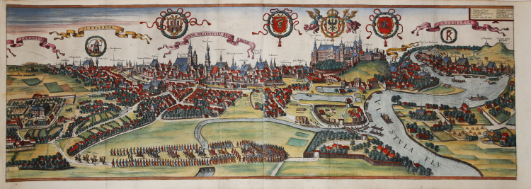
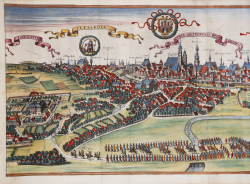
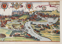
Spectacular view depicting the thriving city of Kraków on the Vistula River, offering a fine contemporary representation of the city and the neighboring towns of Kazimierz and Kleparz and smaller villages. In addition to the buildings, which are often depicted with great attention to architectural detail, it also shows the network of roads, rivers, suburban fields, gardens, and extensive pastures, as well as details of the daily occupations of the inhabitants, such as the rafters taking their rafts down the Vistula River. A royal procession is depicted in the foreground, with the king moving from Wawel Castle to his country residence in Lobzów. The view includes a legend naming the main landmarks, while fifty others are described in the printed image. The Latin names of the towns of Kleparz, Kraków, and Kazimierz are embedded in banners above each town (Clepardia, Kraków, Kazimierz). Above Wawel, the royal residence, are (from left) the Sforza Serpent, the Eagle and the Lithuanian “Hunt.” Kazimierz was a Jewish town founded for the Jewish community of Krakow by the Polish kings. Under the banner on which CASIMIRIA stands, below and to the left reads “Oppidum Iudeorum” (Jewish Settlement) describing the Jewish quarter of Kraków.
The first volume of the Civitates Orbis Terrarum was published in Cologne in 1572. The sixth and the final volume appeared in 1617. This great city atlas, edited by Georg Braun and largely engraved by Franz Hogenberg, eventually contained 546 prospects, bird-eye views and map views of cities from all over the world. Fransz Hogenberg produced the plates for the first four books, and Simon van den Neuwel (Novellanus, active since 1580) those for volumes V and VI.
Georg Braun (1541-1622), a cleric of Cologne, was the principal editor of the work, and was greatly assisted in his project by the close, and continued interest of Abraham Ortelius, whose Theatrum Orbis Terrarum of 1570 was, as a systematic and comprehensive collection of maps of uniform style, the first true atlas. The Civitates, indeed, was intended as a companion for the Theatrum, as indicated by the similarity in the titles and by contemporary references regarding the complementary nature of two works. Nevertheless, the Civitates was designs to be more popular in approach, no doubt because the novelty of a collection of city plans and views represented a more hazardous commercial undertaking than a world atlas, for which there had been a number of successful precedents. Franz Hogenberg (1535-1590) was the son of a Munich engraves who settled in Malines. He engraved most of the plates for Ortelius's Theatrum and the majority of those in the Civitates and may have been responsible for originating the project.
Over a hundred of different artists and cartographers, the most significant of whom was Antwerp artist Georg Hoefnagel (1542-1600), engraved the cooper-plates of the Civitates from drawings. He not only contributed most of the original material for the Spanish and Italian towns but also reworked and modified those of other contributors. After Hoefnagel's death his son Jakob continued the work for the Civitates.
The author set out to depict "non icones et typi urbium," that is, not generic and typified images, "sed urbes ipsae admirabili caelaturae artificio, spectantium oculis subiectae appareant": not intended to allude or idealize but to represent faithfully on paper, to reproduce exactly, and in real time, what the eye sees, as announced in the preface to the first volume of Civitates Orbis Terrarum.
Copperplate engraving with fine hand colour, in very good condition.
Bibliografia
Van der Krogt 4 - #2151; Niewodniczanski - K105/6.6.
|
George Braun (1541-1622), cleric of Cologne, was the principal editor of the Civitates Orbis Terrarum, and was greatly assisted in his project by the close, and continued interest of Abraham Ortelius, whose Theatrum Orbis Terrarum of 1570 was, as a systematic and comprehensive collection of maps of uniform style, the first true atlas.
Franz Hogenberg (1535-1590) was the son of a Munich engraves who settled in Malines. He engraved most of the plates for Ortelius's Theatrum and the majority of those in the Civitates, and may have been responsible for originating the project.
|
|
George Braun (1541-1622), cleric of Cologne, was the principal editor of the Civitates Orbis Terrarum, and was greatly assisted in his project by the close, and continued interest of Abraham Ortelius, whose Theatrum Orbis Terrarum of 1570 was, as a systematic and comprehensive collection of maps of uniform style, the first true atlas.
Franz Hogenberg (1535-1590) was the son of a Munich engraves who settled in Malines. He engraved most of the plates for Ortelius's Theatrum and the majority of those in the Civitates, and may have been responsible for originating the project.
|