
| Reference: | S1450 |
| Author | Giovanni Antonio MAGINI |
| Year: | 1713 |
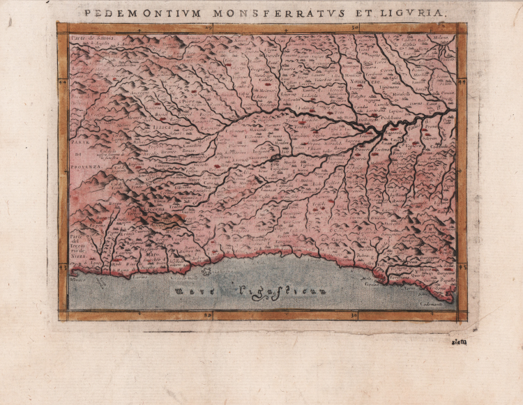
| Zone: | Piemonte, Liguria |
| Printed: | Padua |
| Measures: | 180 x 140 mm |
| Reference: | S1450 |
| Author | Giovanni Antonio MAGINI |
| Year: | 1713 |
| Zone: | Piemonte, Liguria |
| Printed: | Padua |
| Measures: | 180 x 140 mm |
Carta geografica preparata per la "Geographia" di Claudio Tolomeo curata dal Magini, per la prima volta stampata a Venezia nel 1596, presso gli Eredi di Simon Galignani de Karera.
La raccolta maginiana contiene 64 incisioni in rame finemente intagliate da Girolamo Porro e fu poco dopo copiata da Petrus Keschedt, un editore di Colonia (le mappe delle due edizioni sono pressoché indistinguibili).
Una successiva ristampa del lavoro di Magini, con la traduzione di Leonardo Cernoti dal testo latino, vine stampata a Padova dai fratelli Galignani nel 1621.
Esemplare tratto dall'opera di Lasor a Varea (o Varela), pseudonimo di Raffaello Savonarola, "Universus Terrarum Orbis calamo delineatus…" pubblicato a Padova nel 1713 da Matteo Cadorin, una sorta di enciclopedia che conteneva notizie sulle varie località del mondo disposte in ordine alfabetico.
Incisione in rame, finemente colorata a mano, in ottimo stato di conservazione.
Giovanni Antonio MAGINI (1555 - 1617)
|
Giovanni Antonio Magini was born in Padua in 1555, dedicating himself to the study of astronomy from an early age. In 1588 the Senate of Bologna appointed him Lecturer of Astronomy at the local University, choosing him instead of Galileo Galilei. His friendship with the Duke of Mantua, Vincenzo Gonzaga, helped Magini in his quest to obtain cartographical material for map-making from the various sovereigns ruling the different Italian states at that time. Because of Magini's early death in 1617, this effort was made famous by his son Fabio when he published the atlas "L'Italia" in Bologna in 1620. This is the first example of an Italian atlas and is made up of 24 pages of descriptive text and 61 maps of the Italian peninsula. Although this work was published posthumously, it can be entirely ascribed to Magini. He began drawing this maps around 1594, with the one depicting Bologna and its surrounding territories being the first. They were all printed before 1620 in draft editions which were then revised and updated for the final version. These draft proofs are extremely rare, although sometimes available for sale, and exhibit substantial differences in respect to the maps finally included in the atlas. Two of the most famous engravers of the time, Arnoldo Arnoldi and the englishman Benjamin Wright, were entrusted by Magini to engrave the plates. As we shall see in the presentation of the separate maps, they derive from different sources, both known and unknown, and therefore represent the result of an original work of critical analysis and compilation. This atlas had an important influence on the cartography of the italian peninsula for the following two centuries, beginning from Ortelius and going on to the principal dutch cartographers and editors.
|