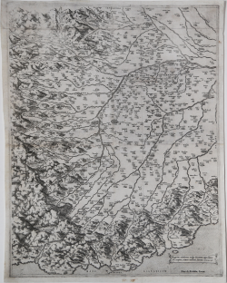
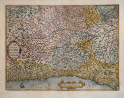
Regionis subalpinae vulgo Piemonte appellatae discriptio, aeneis... Antonio LAFRERI Code: S1651 Measures: 400 x 505 mm Year: 1560 ca. Printed: Rome Price €4,250.00 Quick view View Details
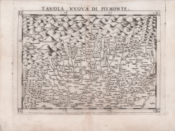
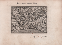
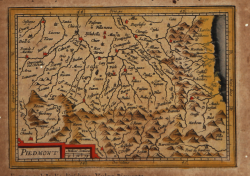
Tavola Nuova di Piemonte Girolamo RUSCELLI Code: S13571 Measures: 260 x 185 mm Year: 1561 ca. Printed: Venice Price €300.00 Quick view View Details
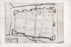
Il vero disegno et ritratto della fortezza di Crescentino Paolo FORLANI Code: S40248 Measures: 283 x 200 mm Year: 1567 Price €450.00 Quick view View Details
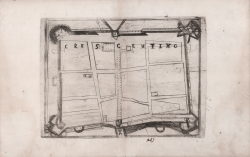
Crescentino Ferrando BERTELLI Code: S39319 Measures: 240 x 180 mm Year: 1568 ca. Printed: Venice Price €675.00 Quick view View Details
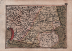
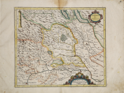
Pedemontanae Vicinorvmqve Regionvm Avctore Iacobo Castaldo descrip. Abraham ORTELIUS Code: s6615 Measures: 490 x 375 mm Year: 1570 ca. Printed: Antwerpen Price €800.00 Quick view View Details
Pedemontanae Vicinorumq(ue) Abraham ORTELIUS - Philip GALLE Code: s33944 Measures: 107 x 80 mm Year: 1577 ca. Printed: Antwerpen Price €150.00 Quick view View Details
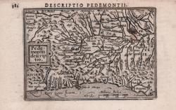
Pedemontanvs Principatus Jan MATAL [METELLUS] Code: s25018 Measures: 205 x 155 mm Year: 1579 ca. Printed: Cologne Price €1,200.00 Quick view View Details
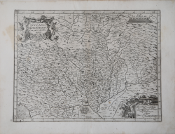
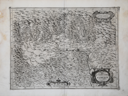
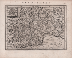
Pedemontana Regio cum Genuensium territorio & Montisferrati... Gerard MERCATOR (Kremer) Code: s27286 Measures: 450 x 367 mm Year: 1589 ca. Printed: Duisburg Price €800.00 Quick view View Details
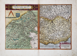
Biturigum provinciae quae Berry vulgo... Gerard DE JODE Code: s29391 Measures: 515 x 360 mm Year: 1593 Printed: Antwerpen Price €1,800.00 Quick view View Details
Ducato del Monferrato con parte del Piemonte Giovanni Antonio MAGINI Code: S7406 Measures: 455 x 345 mm Year: 1597 ca. Printed: Bologna Price €300.00 Quick view View Details
Piemonte et Monferrato Giovanni Antonio MAGINI Code: S48754 Measures: 485 x 385 mm Year: 1597 ca. Printed: Bologna Price €475.00 Quick view View Details
Pedemontii descriptio Barent LANGENES Code: S22006 Measures: 122 x 85 mm Year: 1598 ca. Printed: Amsterdam Price €130.00 Quick view View Details
Signoria di Vercelli Giovanni Antonio MAGINI Code: S7569 Measures: 415 x 360 mm Year: 1600 ca. Printed: Bologna Price €275.00 Quick view View Details
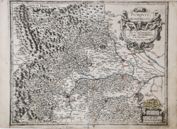
Stato del Piemonte Giovanni Antonio MAGINI Code: s29393 Measures: 470 x 360 mm Year: 1602 ca. Printed: Bologna Price €350.00 Quick view View Details
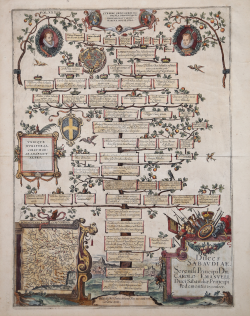
Duces Sabavdiæ. Serenias Principi dn. Carolo Emanveli Duci Sabaudiæ... Antonio ALBIZZI Code: CO-060 Measures: 375 x 520 mm Year: 1612 ca. Printed: Augsburg Price €600.00 Quick view View Details
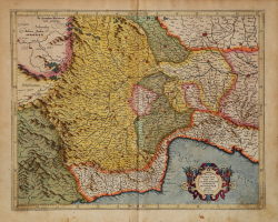
Nel presente disegno di geografia, benigni lettori, trovarette il... Luigi ROSACCIO Code: S38511 Measures: 492 x 395 mm Year: 1613 ca. Printed: Florence Price €8,000.00 Quick view View Details
Piedmont Jodocus HONDIUS Jr. Code: S25051 Measures: 132 x 95 mm Year: 1616 ca. Printed: Amsterdam Price €100.00 Quick view View Details
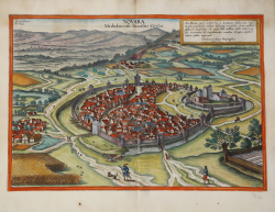
Novara, Mediolanensis Ducatus Civitas Georg BRAUN & Franz HOGENBERG Code: S49238.84 Measures: 475 x 330 mm Year: 1617 ca. Printed: Antwerpen & Cologne Price €800.00 Quick view View Details
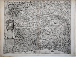
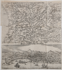
Regio oder Landschaft, darin jetziger Zeit der Krieg in... Georg KELLER Code: s38277 Measures: 298 x 328 mm Year: 1625 Printed: Frankfurt Price €1,500.00 Quick view View Details
Pedemontana regio cum Genuensium territorio & Montisferrati... Johannes JANSSONIUS Code: S48163 Measures: 190 x 140 mm Year: 1628 ca. Printed: Amsterdam Price €125.00 Quick view View Details