
| Reference: | S48520 |
| Author | Johannes JANSSONIUS |
| Year: | 1657 ca. |
| Zone: | Pavia |
| Printed: | Amsterdam |
| Measures: | 450 x 335 mm |
| Reference: | S48520 |
| Author | Johannes JANSSONIUS |
| Year: | 1657 ca. |
| Zone: | Pavia |
| Printed: | Amsterdam |
| Measures: | 450 x 335 mm |
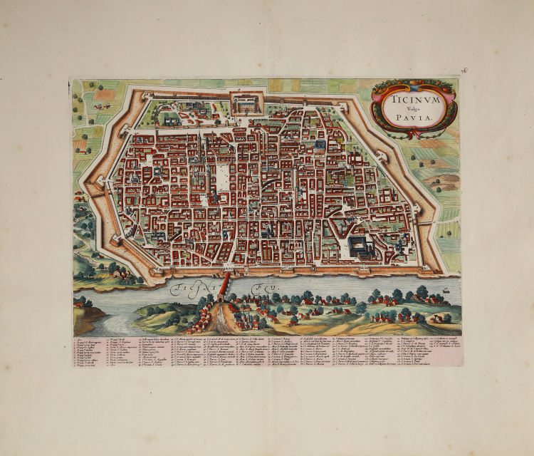
Traduzione olandese della celebre prima pianta prospettica della città di Pavia, la ANTIQUISSIMAE AC CELEBERRIMAE REGIAEQ[UE] PAPIAE ICON di Lodovico Corte, incisa a Roma da Giovanni Maggi nel 1600. L’opera è dedicata dal Corte a Domenico Achillio, illustre pavese. Si tratta della prima rappresentazione urbanistica coerente della città, che anticipa la famosa “pianta di Ballada” del 1654, ma disegnata dallo stesso Corte nel 1617.
La pianta è pubblicata nel "Theatrum praecipuarum urbium" celebre teatro delle città del Janssonius, sullo stile del "Civitates Orbis Terrarum" di Braun & Hogenberg. L'opera, pubblicata nel 1657, contiene 500 tavole raffiguranti città di ogni parte del mondo.
Contrariamente al lavoro degli acerrimi rivali Blaeu, Janssonius si servì per la realizzazione dell'opera delle lastre di precedenti cartografi ed editori. In particolare nel 1653 egli acquisto da Abraham Hogenberg le lastre del "Civitates orbis Terrarum" che incorporò nella sua opera, ristampandole. Per le piante delle città olandesi, ordinò delle nuove lastre basate sull'atalnte che Johannes Blaeu diede alla luce nel 1649.
Per molte delle opere contenute nel 5° volume, quello dedicato all'Italia e denominato "Theatrum celebriorum urbium Italiae..", si servì delle lastre realizzate da Jodocus Hondius per l'opera "Italia Hodierna.." del 1627.
Questa pianta di Pavia, incisa da Wenzel Hollar, è una delle aggiunte fatte fare da Janssonius per il suo Theatrum.
Successivamente le lastre furono ristampate da Janssonius -Waesberghe "Tooneel der vermaarste Koop-Steden", Amsterdam 1682, da Frederick de Wit e da Pieter Vander AA nel secolo successivo.
Mappa tratta dall'edizione di De Wit. Molto rara.
Acquaforte, finemente colorata a mano, in ottimo stato di conservazione.
Johannes JANSSONIUS (1588-1664)
|
Johannes Janssonius, more commonly known to us as Jan Jansson, was born in Arnhem where his father was a bookseller and publisher (Jan Janszoon the Elder). In 1612 he married the daughter of the cartographer and publisher Jodocus Hondius, and then set up in business in Amsterdam as a book publisher. In 1616 he published his first maps of France and Italy and from then onwards he produced a very large number of maps, perhaps not quite rivalling those of the Blaeu family but running a very close second in quantity and quality. From about 1630 to 1638 he was in partnership with his brother-in-law, Henricus Hondius, issuing further editions of the Mercator/Hondius atlases to which his name was added. On the death of Henricus he took over the business, expanding the atlas still further, until eventually he published an 11-volume Atlas Major on a scale similar to Blaeu's Atlas Major.
The first full edition of Jansson's English County Maps was published in 1646 but some years earlier he issued a number of British maps in the Mercator/Hondius/Jansson series of atlases (1636-44); the maps were printed from newly engraved plates and are different from the later 1646 issue and are now rarely seen (see Appendix B for further details).
In general appearance Jansson's maps are very similar to those of Blaeu and, in fact, were often copied from them, but they tend to be more flamboyant and, some think, more decorative.
After Jansson's death his heirs published a number of maps in an Atlas Contractus in 1666 and later still many of the plates of his British maps were acquired by Pieter Schenk and Gerard Valck, who published them again in 1683 as separate maps.
|