
| Reference: | MS7002 |
| Author | Charles V. MONIN |
| Year: | 1836 |
| Zone: | Oceania |
| Printed: | Paris |
| Measures: | 680 x 490 mm |
| Reference: | MS7002 |
| Author | Charles V. MONIN |
| Year: | 1836 |
| Zone: | Oceania |
| Printed: | Paris |
| Measures: | 680 x 490 mm |
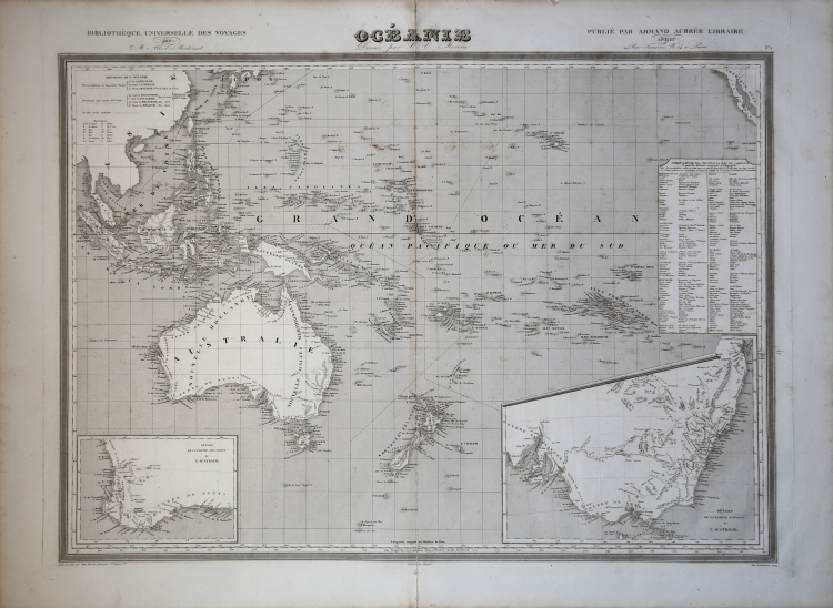
Uncolored engraved map. Relief shown by hachures. Rivers shown.
Insets for southeastern Australia and southwestern Australia. Inset table showing the nomenclature for the principal islands in the South Pacific. Taken from 'Univers. Atlas Classique Et Universel De Geographie Ancienne Et Moderne. Dresse Par M. Monin, Membre de la Societe de geographie, et M. Fremin, Geographe du Depot de la guerre ... Paris.
Armand Aubree, Edteur, Rue De Vaugirard, 17. 1837.
Charles V. MONIN (attivo a Parigi 1830 - 1880)
|
Charles V. Monin (1830 - 1880) was a French map publisher working the early to mid 19th century. A progressive printer, Monin was one of the first cartographic printers in Europe to take advantage of the newly discovered lithographic engraving process. His workshops in Paris and Caen, France, produced three important atlases as well as numerous independent issue maps. Monin was a member of La Sociéte de Géographie in Paris. He is known to have worked with other French map publishers including Vuillemin and Fremin.
|