| Reference: | MS7570 |
| Author | James COOK |
| Year: | 1774 ca. |
| Zone: | Society Islands |
| Printed: | Venice |
| Measures: | 510 x 240 mm |
| Reference: | MS7570 |
| Author | James COOK |
| Year: | 1774 ca. |
| Zone: | Society Islands |
| Printed: | Venice |
| Measures: | 510 x 240 mm |
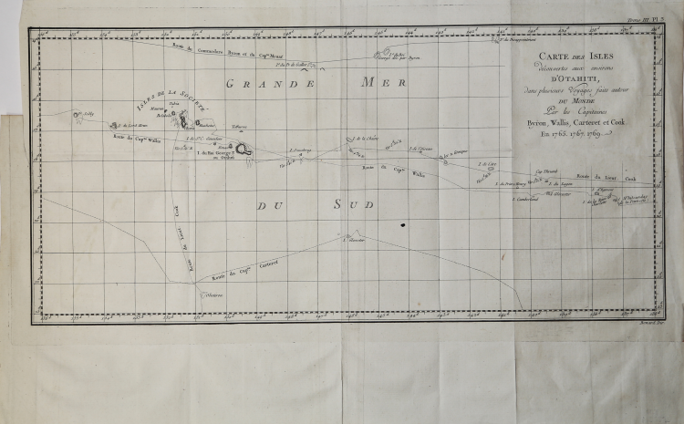
Map taken from the atlas by James Hawkesworth "Cartes et figures des voyages entrepris par ordre de sa Majesté Britannique pou fair des découvertes dans l'hémisphère méridional; exécutes par Byron, Carteret, Wallis & Cook dans les vaisseaux le Dauphin, Le Swallow & l'Endeavour" published in more edition in french, english, duth and italian.
Fine map shows the explorations of Captain Cook, Captain Byron, Captain Wallis and Captain Carteret in the vicinity of Tahiti and the Society Islands from 1765 to 1769. Extends from Is. Scilly [i.e. the Scilly Islands] in the west and to I. Whitsunday de la Pentecote [i.e. the Whitsunday Island] in the east, from Is. du Disappointment [i.e. Disappointment Island] in the north to Ohetiroa in the south. Features the routes taken by these important explorers as the zig-zagged in and around the Society Islands. Depicts the island of Tahiti (Otaheite) as well as Bora Bora (Bolabola), Otaha, Marma, Ulietea, and others. Title in decorative script in the upper right quadrant.
Copper engraving, in excellent condition.
|
Captain James Cook (7 November 1728 - 14 February 1779) is a seminal figure in the history of cartography for which we can offer only a cursory treatment here. Cook began sailing as a teenager in the British Merchant Navy before joining the Royal Navy in 1755. He was posted in America for a time where he worked Samuel Holland, William Bligh, and others in the mapping of the St. Lawrence River and Newfoundland. In 1766 Cook was commissioned to explore the Pacific and given a Captaincy with command of the Endeavour. What followed were three historic voyages of discovery, the highlights of which include the first European contact with eastern Australia, the discovery of the Hawaiian Islands (among many other Polynesian groups), the first circumnavigation of New Zealand, some of the first sightings of Antarctica, the first accurate mapping of the Pacific Northwest, and ultimately his own untimely death at the hands of angry Hawaiians in 1779.
|
|
Captain James Cook (7 November 1728 - 14 February 1779) is a seminal figure in the history of cartography for which we can offer only a cursory treatment here. Cook began sailing as a teenager in the British Merchant Navy before joining the Royal Navy in 1755. He was posted in America for a time where he worked Samuel Holland, William Bligh, and others in the mapping of the St. Lawrence River and Newfoundland. In 1766 Cook was commissioned to explore the Pacific and given a Captaincy with command of the Endeavour. What followed were three historic voyages of discovery, the highlights of which include the first European contact with eastern Australia, the discovery of the Hawaiian Islands (among many other Polynesian groups), the first circumnavigation of New Zealand, some of the first sightings of Antarctica, the first accurate mapping of the Pacific Northwest, and ultimately his own untimely death at the hands of angry Hawaiians in 1779.
|