
| Reference: | CO-002 |
| Author | Franz Johann von REILLY |
| Year: | 1798 ca. |
| Zone: | Umbria |
| Printed: | Wien |
| Measures: | 330 x 286 mm |
| Reference: | CO-002 |
| Author | Franz Johann von REILLY |
| Year: | 1798 ca. |
| Zone: | Umbria |
| Printed: | Wien |
| Measures: | 330 x 286 mm |
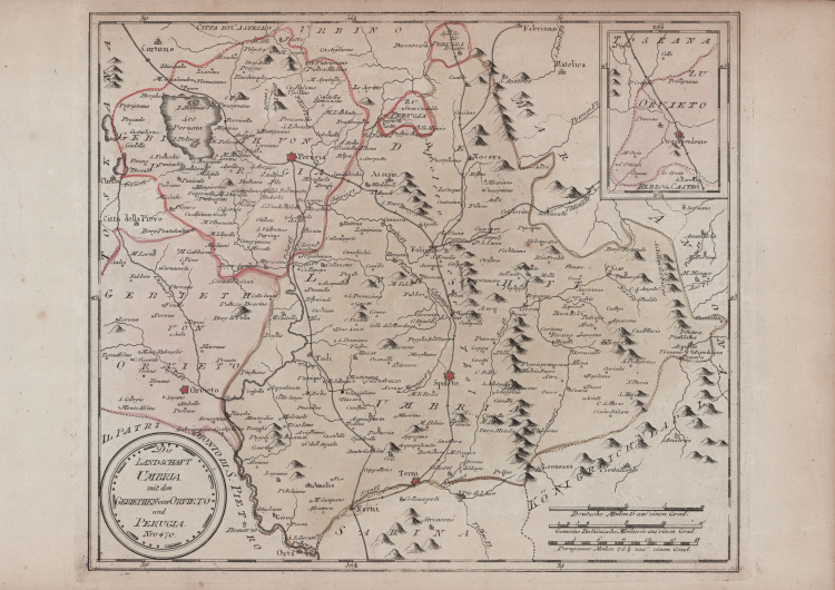
Carta geografica dell’Umbria compresa nei territori di Perugia e Orvieto.
Pubblicata a Vienna da Franz Johann Joseph von Reilly nello Schauplatz der fünf Theile der Welt mit beständiger Rücksicht auf die besten Originalwerke in drey Theile zusammengetragen von einer Gesselschaft Geographen nach zu Büschings Grosser Erdbeschreibung.
Reilly (1766-1820) pubblicò l’atlante al ritmo di una mappa a settimana per 17 anni dal giugno 1789 al luglio 1806, producendo, in totale, circa 830 mappe dell'Europa. Una terza parte dell'atlante era prevista per coprire il resto del mondo, ma non fu mai pubblicata.
Secondo Satolli l’autore della carta sarebbe Anton Friedrich Büsching: “Come si deduce dal titolo dell'Atlante in cui la mappa è stata pubblicata la prima volta, l'autore del disegno è il cartografo tedesco Anton Friederich Büschings e l'incisore è Ignaz Albrecht'. L'Atlante fu pubblicato dal mercante d'arte viennese Franz Johann Joseph von Reilly (1766-1820) che tra il 1789 e il 1806 - proprio nel periodo delle campagne napoleoniche, quando i confini erano piuttosto labili- produsse almeno 830 mappe e quelle riguardanti l'Italia furono pubblicate tra l'agosto 1797 e il giugno 1799. Il territorio orvietano, non incluso interamente nella tavola d'insieme, è rappresentato in parte nel riquadro in alto a destra” (cfr. Satolli, Imago VV, Le rappresentazioni della città di Orvieto dalle origini ad oggi, p. 179).
Acquaforte, coloritura editoriale, in ottimo stato di conservazione.
Bibliografia
Alberto Satolli, Imago VV, Le rappresentazioni della città di Orvieto dalle origini ad oggi, p. 179, tav. LXXV; Ronca- Sorbini, Le antiche terre del Ducato di Spoleto (2015), pp. 222 e 293.
Franz Johann von REILLY (Vienna 1766 - 1820)
|
He was a Viennese art dealer who in his early twenties turned to map publishing, and between the years 1789 and 1806 produced a total of no less than 830 maps. His Schauplatz…der Welt (World Atlas) in fact covered only maps of Europe, whilst the Grosser Deutscher Atlas also included maps of other continents and was, therefore, the first World Atlas produced by an Austrian.
1789-1806 Schauplatz der funf Theile der Welt
1794-96 Grosser Deutscher Atlas
|