| Reference: | CO-677 |
| Author | Barent LANGENES |
| Year: | 1598 ca. |
| Zone: | Orvieto |
| Printed: | Amsterdam |
| Measures: | 125 x 90 mm |
| Reference: | CO-677 |
| Author | Barent LANGENES |
| Year: | 1598 ca. |
| Zone: | Orvieto |
| Printed: | Amsterdam |
| Measures: | 125 x 90 mm |
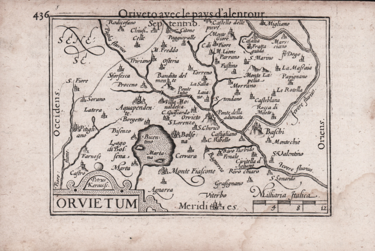
Rare map first published in Barent Langenes' "Caert-thresoor" published in Amstredam by Cornelis Claesz in 1598. Example from the later 1599 reprint with French text called "Thrésor de chartes" also published by Cornelis Claesz in 1599.
At the end of the 16th century the most famous and marketed "pocket" atlas was Abraham Ortelius' Epitome. In 1598 the publishers Barent Langenes and Cornelis Claesz brought to print a collection of superior quality. The plates are entrusted to skilled engravers such as Pieter Kaerius and Jodocus Hondius.
Copperplate engraving, a light waterstain at the lower right corner, otherwise in excellent condition.
Bibliografia
King, Miniature Antique Maps, pp. 80-82; Alberto Satolli, Imago VV, Le rappresentazioni della città di Orvieto dalle origini ad oggi, p. 128, tav. XL.
Barent LANGENES (Attivo nella seconda metà del XVI sec.)
|
Dutch publisher and engraver of Middelburg, he is renowned for his miniature atlases, which can be considered as a model for the following corresponding atlases. His most famous work has been published in Middelburg inl 1598, the "Caert Thresoor". The maps have been engraved by Pieter van den Keere and Jodocus Hondius and have been used for various translations and for Bertius' Tabularum Geographicarum.
|