| Reference: | CO-553 |
| Author | Herman MOLL |
| Year: | 1730 ca. |
| Zone: | Northern Italy |
| Printed: | London |
| Measures: | 1030 x 635 mm |
| Reference: | CO-553 |
| Author | Herman MOLL |
| Year: | 1730 ca. |
| Zone: | Northern Italy |
| Printed: | London |
| Measures: | 1030 x 635 mm |
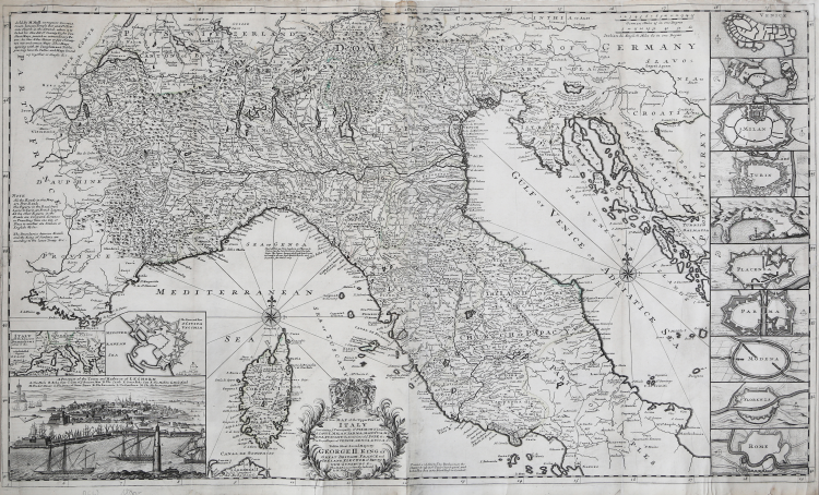
A New Map of the Upper Part of Italy Containing the Principality of Piemont ye Dutchies of Savoy, Milan, Parma, Mantua, Modena, Tuscany, the Dominions of ye Pope &c. The Republics of Venice, Genoa, Lucca & c. / to His Most Sacred Majesty George II. King of Great Britain, France and Ireland, Elector of Brunswick-Luneburg &c. this Map is most humbly dedicated.
Firma in lastra: "Printed and Sold by Tho: Bowles next the Chapter House in St. Paul Church yard, and Iohn Bowles and Son, at y.e Black Horse in Cornhil" [nelle tre righe scritte a destra del cartiglio, in basso]; "by H. Moll Geographer" [entro il cartiglio]; priva di data, ma dedicata a Giorgio II (1683-1760), re di Gran Bretagna, Francia e Irlanda, Duca di Brunswick-Lünenburg, Principe elettore del Sacro Romano Impero dall'11 giugno 1727 fino alla morte.
Incisione su rame, senza testo al verso, coloritura d'epoca dei confini. Orientazione normale (nord in alto), data da due rose dei venti a 8 punte e 16 linee, con il fleur-de-lis a segnare il nord, circa al centro del Mar Tirreno e del Mare Adriatico. Margine graduato lungo tutta la cornice, numerato, due scale grafiche: in miglia tedesche ("German Miles 15 in one Degree"), e italiane & inglesi ("Italian & English Miles 60 in one Degree").
Include 11 inserti con dieci piante di fortificazioni di città (Venezia, Mantova, Milano, Torino, Genova, Piacenza, Parma, Modena, Firenze, Roma e Civitavecchia) e una pianta prospettica della città e del porto di Livorno.
“Innegabile il fascino espresso da questo esemplare, a partire dalle sue dimensioni, fino all'elaborato e raffinato schema compositivo ove, insieme alla raffigurazione geografica dell'Italia del Centro e del Nord, trovano spazio numerose componenti illustrative e particolareggiate di questo stesso contesto geopolitico. Sulla destra appare in bella evidenza, per tutta l'altezza del foglio, una lunga striscia, suddivisa in dieci riquadri, ciascuno dei quali riporta la sommaria planimetria di una città, iniziando da Venezia giù fino a Roma. In basso, appena a lato della Corsica, con la Sardegna a fare capolino, si adagia sulla scala longitudinale il titolo, seguito dal sottotitolo esplicativo del contenuto e con la dedica a Re Giorgio II. Il tutto racchiuso da un delicato cartiglio di tralci vegetali intrecciati, sul quale troneggia il blasone del Regno Unito. Ciò che tuttavia non passa inosservato è il riquadro del quarto inferiore sinistro con il notevole prospetto della città e del porto di Livorno, sovrastato dalla planimetria di Civitavecchia e da una piccola raffigurazione geografica dell'Italia, circondata dagli Stati circostanti. La ricchezza e il dettaglio dell'inserto ne fanno una stampa a sé nel contesto figurativo generale. La peculiare attenzione dedicata a Livorno, con l'originale e minuziosa veduta, sta a indicare quanto fosse importante per i mercantili inglesi in transito nel Mediterraneo questo scalo marittimo, potendo qui fruire dell'esenzione dalle tasse doganali, perché la città era "porto franco" fin dall'inizio del '600. Puntuale e appropriata è la nota situata nell'angolo superiore sinistro, con la quale si specifica il luogo dove Moll vende le sue carte, nella corte di Devreux, tra il Temple Bar e la chiesa di San Clemente nello Strand. Qui si può acquistare il nuovo insieme di 28 carte a doppia pagina, stampate su carta speciale, unite alle tavole di testo di Templeman - ma testi e carte si possono avere anche singolarmente - nonché l'Atlas Minor con 62 carte nuove e corrette. L'insieme a cui si fa cenno è sicuramente The World Described, pubblicato nel 1717 con 25 carte e accresciuto fino a 30 nelle edizioni successive, l'ultima del 1736. Una di queste, realizzata in 28 tavole, contiene alla n. 25 A New Map of Italy, datata in lastra 1714, e alla n. 26 A New Map of the Upper Part of Italy, la cui dedica a Giorgio II presuppone una datazione successiva al 1727, anno della sua ascesa al trono”. (cfr. P. Giorgi, C. Cicioni, L’Italia di Mezzo, La cartografia storica del Centro Italia dal XVI al XIX secolo, n. 46).
Herman Moll (1654 - 1732) fu uno dei più importanti editori dediti al commercio di mappe in Inghilterra tra la fine del XVII e l’inizio del XVIII secolo. Sembra probabile che provenisse dalla Germania, forse da Brema, e che fosse a Londra già nel 1678. Le poche notizie biografiche sono dedotte dalla produzione, notevole, di materiale cartografico, frutto dell’attività alla quale si dedicava - come uso all’epoca - in qualità di incisore, disegnatore o editore. Dalla sua morte, nel 1732, della casa editrice Moll non si hanno più tracce; suo figlio Gilles Hendrick scomparve, infatti, prematuramente mentre la figlia Henderina Amelia Moll, è poco più che un nome testamentario. Le prime notizie di Moll sono relative al 1678 dove, come incisore, lavora per l’English Atlas di Moses Pitt e Sir Robert Hooke, uno dei sostenitori del progetto. Gran parte della sua carriera fu dedicata all’attività di incisore per produttori di mappe e editori, in particolare per James Knapton, realizzando le mappe per i resoconti di viaggio. Nel 1707 Moll iniziò a lavorare alla sua pubblicazione più famosa, il The World Described, una raccolta di mappe del mondo. Fu uno dei più famosi atlanti inglesi del XVIII secolo e richiese un lungo periodo di lavorazione; l’atlante fu completato solo nel 1717. Moll usava riempire gli spazi vuoti delle sue mappe con pannelli di testo, spesso con descrizione della regione raffigurata; altre volte, invece, con commenti poco lusinghieri sui rivali: gli inglesi Jeremiah Seller e Charles Price, John Senex e in particolare il francese Guillaume Delisle. Herman Moll fu coinvolto in numerose pubblicazioni: il Thesaurus Geographicus (1695), ripubblicato in seguito con diverse altre forme e ampliato per formare l’Atlas Geographus (1711) il Twenty Four New and Accurate Maps of the Several Parts of Europe (1706) e A New Description of England and Wales (1724). Nel suo testamento, non si fa menzione di uno stock di lastre da stampa o altri beni aziendali. È probabile che gran parte del materiale a cui il suo nome è legato fosse posseduto e finanziato da altri editori.
Bibliografia
M. G. Cocco in Associazione Roberto Almagià (a cura di) “L’Italia di mezzo, La cartografia storica del Centro Italia dal XVI al XIX secolo nelle collezioni private”, pp. 46-47, n. 18; P. Giorgi, C. Cicioni, L’Italia di Mezzo, La cartografia storica del Centro Italia dal XVI al XIX secolo, n. 46
|
Herman Moll came to London in about 1678 and worked as an engraver for other publishers, such as Moses Pitt, Greenville Collins. John Adair, and Seller & Price, but soon set up his own business publishing atlases and also separate maps of all parts of the world. His work was varied, ranging from miniature maps to large very decorative wall maps. The first maps engraved by Moll in his own right were prepared for the atlas volume accompanying Sir Jonas Moore’s New System Of The Mathematicks …, in which he began to develop his characteristic engraving style.
Maps in Moll’s large folio atlas, The World Described are clearly printed with large cartouches, enclosing the title and dedication and often with large vignettes. This atlas contained one of the largest world maps of the early eighteenth century to appear in atlas form. Published in 1724 the map is somewhat outdated (despite its author’s claims), showing California as an Island long after the French maps of around 1700 had depicted it as a peninsula. Perhaps his most famous map is the New and Exact Map of the Dominions of the King of Great Britain on ye Continent of North America, depicting the English colonies along the east coast. The map is more popularly called the “Beaver Map”, after the attractive vignette scene showing beavers building dams.
Jonathan Swift, it is said, referred to Moll’s maps in the writing of Gulliver’s Travels, thereby adding greater credibility to his story by ensuring the location of the islands visited by Gulliver could not be disputed.
Moll’s other works include the Atlas Manuale (1709), New and Complete Atlas (1719), the Atlas Minor (1729) and Atlas Geographus (1711-17) in five volumes.
Moll also published a fine series of county maps, in the New Description of England, published in 1724. The maps are famous for their side panels with drawings of architectural remains from the counties. His work was much copied by other publishers and he enjoyed a high reputation.
|
|
Herman Moll came to London in about 1678 and worked as an engraver for other publishers, such as Moses Pitt, Greenville Collins. John Adair, and Seller & Price, but soon set up his own business publishing atlases and also separate maps of all parts of the world. His work was varied, ranging from miniature maps to large very decorative wall maps. The first maps engraved by Moll in his own right were prepared for the atlas volume accompanying Sir Jonas Moore’s New System Of The Mathematicks …, in which he began to develop his characteristic engraving style.
Maps in Moll’s large folio atlas, The World Described are clearly printed with large cartouches, enclosing the title and dedication and often with large vignettes. This atlas contained one of the largest world maps of the early eighteenth century to appear in atlas form. Published in 1724 the map is somewhat outdated (despite its author’s claims), showing California as an Island long after the French maps of around 1700 had depicted it as a peninsula. Perhaps his most famous map is the New and Exact Map of the Dominions of the King of Great Britain on ye Continent of North America, depicting the English colonies along the east coast. The map is more popularly called the “Beaver Map”, after the attractive vignette scene showing beavers building dams.
Jonathan Swift, it is said, referred to Moll’s maps in the writing of Gulliver’s Travels, thereby adding greater credibility to his story by ensuring the location of the islands visited by Gulliver could not be disputed.
Moll’s other works include the Atlas Manuale (1709), New and Complete Atlas (1719), the Atlas Minor (1729) and Atlas Geographus (1711-17) in five volumes.
Moll also published a fine series of county maps, in the New Description of England, published in 1724. The maps are famous for their side panels with drawings of architectural remains from the counties. His work was much copied by other publishers and he enjoyed a high reputation.
|