| Reference: | MS3558 |
| Author | Georg Woolworth COLTON |
| Year: | 1856 |
| Zone: | Denmark |
| Printed: | New York |
| Measures: | 360 x 432 mm |
| Reference: | MS3558 |
| Author | Georg Woolworth COLTON |
| Year: | 1856 |
| Zone: | Denmark |
| Printed: | New York |
| Measures: | 360 x 432 mm |
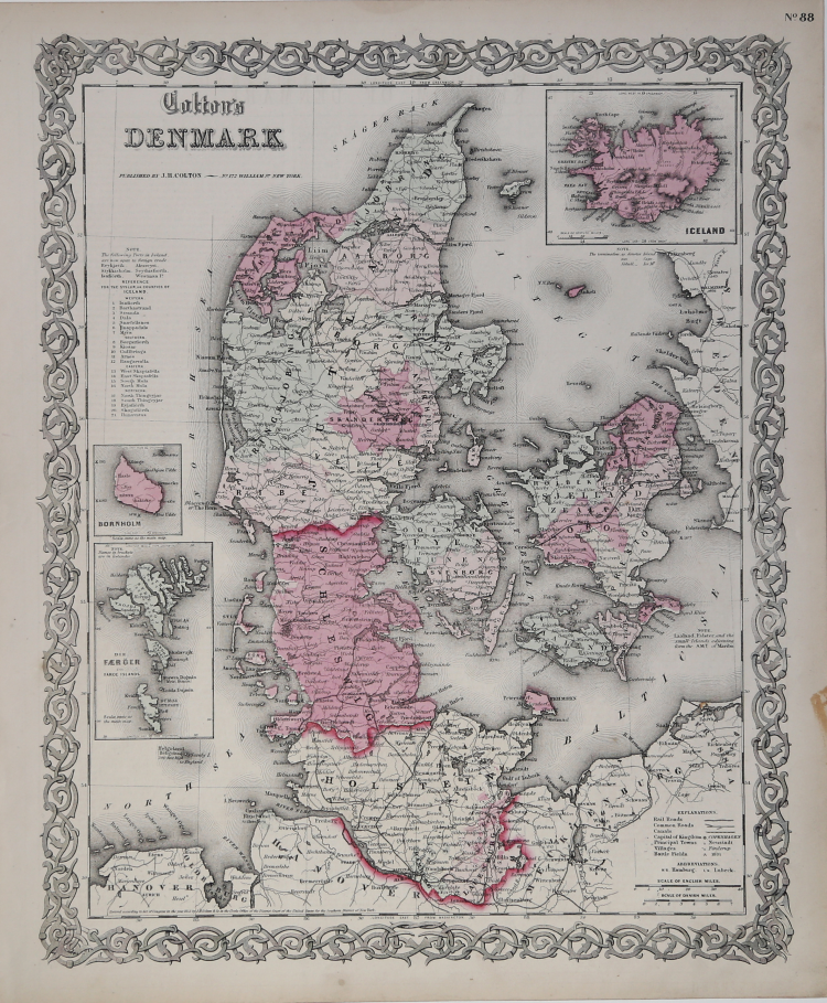
Detailed map of Denmark, hand colored by provinces. Shows towns, roads, rivers, mountains, lakes, islands, etc.
Inset maps of Iceland, Bornhom and Die Faerger or Faroe Islands. Decorative border.
A terrific map, from JH Colton, one of the most prolific American mapmakers of the mid-19th Century. From the scarce 1859 edition, bearing the imprint of Johnson & Browning, one year before these two publishers commenced publication of Johnson's Illustrated Family Atlas of the World. Marvelous vibrant colors.
|
Rumsey 0149.078 (1856 edition); Phillips (Atlases) 816
|
Georg Woolworth COLTON (1827-1901)
|
Joseph Hutchins Colton, known professionally as J.H. Colton, founded an American mapmaking company which was an international leader in the map publishing industry between 1831 and 1890. In the early 1850s Colton brought his two sons into the business, George Woolworth Colton (1827–1901) and Charles B. Colton (1832–1916).
|
|
Rumsey 0149.078 (1856 edition); Phillips (Atlases) 816
|
Georg Woolworth COLTON (1827-1901)
|
Joseph Hutchins Colton, known professionally as J.H. Colton, founded an American mapmaking company which was an international leader in the map publishing industry between 1831 and 1890. In the early 1850s Colton brought his two sons into the business, George Woolworth Colton (1827–1901) and Charles B. Colton (1832–1916).
|