
| Reference: | S27083 |
| Author | Girolamo RUSCELLI |
| Year: | 1560 ca. |
| Zone: | Scandinavia |
| Printed: | Venice |
| Measures: | 265 x 395 mm |
| Reference: | S27083 |
| Author | Girolamo RUSCELLI |
| Year: | 1560 ca. |
| Zone: | Scandinavia |
| Printed: | Venice |
| Measures: | 265 x 395 mm |
Etching and engraving, circa 1560, unsigned and without printing details.
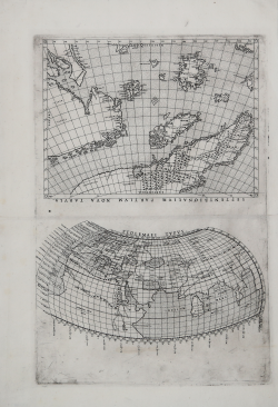
This is the first version, with the title of the Scandinavia map beginning with SEPTENTRIONALIUM (later "corrected" to SEPTENIRIONALIUM), the place name DROGEO (later DEOGEO) at the bottom left, and the graduation in the right margin beginning with the number "50" (later corrected to "59"). Neither Burden nor Ginsberg point out the difference in graduation, among the numerous differences between the first and the later versions of the plate.
This is a very rare first edition, without the text on the verso and before the plate was cut, which occasionally appears in 16th-century collections, the so-called “Lafrery Atlas”.
The first map depicts the Ptolemaic planisphere. The title is printed at the top center: PTOLEMAEI TYPUS. On the left side of the map, we find indications of Ptolemaic climates and the length of the day at various latitudes. The latitude graduations, in degrees, are progressively numbered in 5° increments, from 17° south to 63° north. The equator is marked from 0° to 180° east.
The second map depicts the northernmost part of Europe with Greenland. The title at the top along the edge outside the graduated margin: SEPTENTRIONALIUM PARTIUM NOVA TABULA. The orientation on the four sides is centered with the names of the cardinal points: SEPTENTRIO, MERIDIES, ORIENS, OCCIDENS. The margins are marked with latitude graduations in 5° increments, from 59° to 76°. Longitude graduations in 5° increments range from 312° west to 48° east.
The two maps were later published in La geografia de Claudio Ptolemao Alessandrino Nuouamente tradotta di Greco in Italiano, da Girolamo Ruscelli, first published in Venice by Vincenzo Valgrisi in 1561 and reprinted in several editions until 1598.
The maps are based on the plates by Giacomo Gastaldi compiled for the 1548 Geografia; engraved by the brothers Livio and Giulio Sanuto, these maps were likely also compiled by Gastaldi. Ruscelli's maps were engraved two for each plate, later cut to fit into the quarto size; this is why the copperplate mark appears on only three sides of each map.
The two maps are the only ones in the series to be included in sixteenth-century Lafrery Atlas, always in pairs and without the descriptive text on the verso that accompanies them in Ruscelli's book. We find them, particularly but not exclusively, in collections bearing the title page of Lafreri, Tavole moderne di Geographia. We do not know whether Antonio Lafreri enjoyed some sort of right to sell the map; however, we are not convinced by the claims of Alessia Alberti, who identifies entry no. 4 of the Lafreri Indice (the printing house catalog), "Mappamondo di due pezzi in forma tonda" [World map of two pieces in a round shape], with this sheet (see Alberti, L’Indice di Antonio Lafrery: origini e ricostruzione di un repertorio di immagini a stampa nell’età della Controriforma, p. 113, A3).
The most significant map in Ruscelli's atlas is his Septentrionalium Partium Nova Tabula map, which is based upon the Nicolò Zeno map of the North Atlantic, first included in a 1558 travel book, which describes a pre-Columbian voyage to the "New World" in 1380 by Nicolo and Antonio Zeno. The map introduces many new fictitious islands in great detail, including Frisland (with 32 places named), Deogeo, Estotiland, Estland, and the monastery of S. Tomas in Greenland. Many of these mythical islands and places were depicted on maps for centuries, mainly because Gerard Mercator accepted Zeno's voyage as authentic and adopted much of it in his famous large 1569 world map and his 1595 map of the North Pole. Ortelius in turn used the map as a prototype for his map of the North Atlantic. Frobisher and Davis accepted the map for their explorations in the 1570's and 1580's, respectively.
A magnificent example, printed on a contemporary sheet of laid paper (made from two joined sheets) with a "shield with flower and star" watermark, with full margins, in excellent condition.
Bibliografia
S. Bifolco - F. Ronca, Cartografia e topografia italiana del XVI secolo, n. 19; Burden, The mapping of North America, 29; Ginsberg; Printed Maps of Scandinavia and the Arctic, 19; Shirley, The Mapping of the World, 109; Bella, Cartografia Rara (Collezione Novacco), p. 49, 41; Borroni Salvadori, Raccolte, 3 & 4; Nordenskiold collection 7.
Girolamo RUSCELLI (Viterbo 1504 – Venezia 1566)
|
Girolamo Ruscelli was an Italian humanist, publisher and cartographer active in Venice in the early 16th century. Born in Viterbo, Ruscelli lived in Aquileia, Padua, Rome and Naples before moving to Venice, where he spent most of his life. Cartographically, Ruscelli is best known for his important revision of Ptolemy's Geographia, published in 1561. Based on an expansion of Giacomo Gastaldi's 1548 work Ptolemy, Ruscelli added some 37 new “Ptolemaic” maps to his Italian translation of the Geographia. Ruscelli is also listed as the editor of such important works as Boccaccio's Decameron, Petrarch's verses, Ariosto's Orlando Furioso, and various other works. In addition to his well-known cartographic work, many scholars associate Ruscelli with Alexius Pedemontanus, author of the popular De' Secreti del R. D. Alessio Piemontese. This well-known work, or “Book of Secrets,” was a collection of scientific and quasi-scientific medical recipes, household advice and technical commentary on a range of subjects that included metallurgy, alchemy, dyeing and perfume making. Ruscelli, as Alexius, founded an “Academy of Secrets,” a group of nobles and humanists dedicated to the discovery of “forbidden” scientific knowledge. This was the first known experimental scientific society and was later imitated by numerous other groups throughout Europe, including the Academy of Secrets in Naples.
|