
| Reference: | S50565 |
| Author | Barent LANGENES |
| Year: | 1609 |
| Zone: | Norway |
| Printed: | Frankfurt |
| Measures: | 125 x 90 mm |
| Reference: | S50565 |
| Author | Barent LANGENES |
| Year: | 1609 |
| Zone: | Norway |
| Printed: | Frankfurt |
| Measures: | 125 x 90 mm |
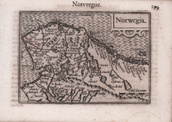
The first map to depict Norway separately
Rare miniature map first published in Barent Langenes' “Caert-thresoor”, 1602.
“Norwegia, the first map to depict Norway separately, appeared in 1602 in the French edition of a miniature atlas published by Cornelis Claesz. Barent Langenes, a bookseller and publisher about whom little is known, originally issued this work as the Caert-Thresoor in Dutch in 1598 in Middelburg, the Netherlands. The Langenes atlas, albeit with rewritten text and from other publishers, enjoyed a commercial success that saw the issuance of a dozen editions over a lengthy period. The title page of the first, 1598 Middelburg edition notes that the atlas was on sale at the shop of Cornelis Claesz in Amsterdam. This was probably done in order to increase sales beyond the Middelburg market. Claesz reissued the atlas in 1599, after removing Langenes’s name, and he and his successors published all the later editions. The series of atlases is now more commonly associated with Petrus Bertius, who undertook the first rewriting of the text for the Latin edition of 1600, where his name is printed on the title page: “P. Bertii Tabularum geographicarum contractarum libri quatuor” (P. Bertius reduced geographical maps in four books). Norwegia occurs in only four of the twelve printings: 1602 and c. 1609 French, 1602/03 and 1649 Latin” (cf. W. Ginsberg, Printed Maps of Scandinavia and the Arctic, 1482-1601, p. 9).
Example from the French text edition of 1609 with the title “Thrésor de Chartes contenant les Tableux de tout les pays du monde, enrichi de belles descriptions, revue & augmenté” printed in Frankfurt by Matthias Becker on behalf of publisher Henry Laurent.
Barent Langenes was a Middelburg publisher about whom not much is known except that he produced the first edition of a well-known miniature atlas, the “Caert-Thresoor”. The atlas was published by Cornelis Claesz of Amsterdam, the leading publisher of the time.
The Caert-Thresoor, a small atlas of the world in oblong format, appeared in 1598; its publishers thus wrote a new page in the history of cartography. Preparations for this prototype of the new generation of Dutch pocket atlases began around 1595. At that time, Cornelis Claesz commissioned the maps from the skilled engravers Jodocus Hondius and Pieter van den Keere. An unnamed young writer and poet, Cornelis Taemsz of Hoorn, was called in to write the accompanying text. Claesz wanted his Caert-Thresoor to surpass the similar small atlases of the world produced up to that time in Antwerp by Abraham Ortelius In this way, he aimed to arouse interest in and knowledge of geography among the general public in the northern Netherlands.
The Caert-Thresoor enjoyed wide interest and from a commercial point of view. Under Claesz's editorship, editions appeared in Dutch (1598, 1599, and 1609), French (c. 1600 and 1602), and Latin (1600, 1602/03, and 1606). But even after his death, the work continued to undergo a series of editions at different publishing houses. Beginning with the 1599 Dutch edition, influenced by Paulus Merula's criticism, most of the maps were given a latitude scale. Claesz approached Aelbert Hendricksz of The Hague to print the French edition based on a translation by I. de la Haye, who was rector and clergyman in Kampen. For the Latin edition, however, production again took place in Amsterdam, but this time in collaboration with a publisher in Arnhem, Jan Jansz. For this edition, scholar Petrus Bertius (1565-1629) produced a completely new geographical description of the entire world. In addition, the maps served as illustrations, unlike earlier editions in which the text was intended to explain the maps. In 1609, the Caert-Thresoor appeared in a new Dutch version, prepared by author and poet Jacobus Viverius (1571/72-c.1636).
Etching, in very good condition.
Bibliografia
King, Miniature Antique Maps, pp. 80-82; W. Ginsberg, Printed Maps of Scandinavia and the Arctic, 1482-1601, p. 9, n. 1.
Barent LANGENES (Attivo nella seconda metà del XVI sec.)
|
Dutch publisher and engraver of Middelburg, he is renowned for his miniature atlases, which can be considered as a model for the following corresponding atlases. His most famous work has been published in Middelburg inl 1598, the "Caert Thresoor". The maps have been engraved by Pieter van den Keere and Jodocus Hondius and have been used for various translations and for Bertius' Tabularum Geographicarum.
|