
| Reference: | S4894 |
| Author | Frederick de WIT |
| Year: | 1680 ca. |
| Zone: | Tartary |
| Printed: | Amsterdam |
| Measures: | 555 x 440 mm |
| Reference: | S4894 |
| Author | Frederick de WIT |
| Year: | 1680 ca. |
| Zone: | Tartary |
| Printed: | Amsterdam |
| Measures: | 555 x 440 mm |
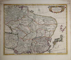
A beautiful example of Frederick de Wit's c. 1680 map of Tartary.
The map covers from just north of the Arctic Circle to Formosa south to the the Bay of Bengal and Formosa, and from the Caspian Sea to Hokkaido or Yedso.
Although parts of China, Japan, and northern India were somewhat mapped, most of northeastern Asia was fully unknown to western cartographers. The continent has here been given a curious rounded form that may be suggestive of a northeasterly route to Asia.
Both the Great Wall of China and the Gobi Desert are clearly delineated. At the western edge of the map the overlarge Caspain Sea is erroneously mapped on an east-west rather than north-south axis.
This map was published both independently and as part of various complied and composite atlases.
Copperplate, very good condition.
Frederick de WIT (1630 - 1706)
|
De Wit was one of the most prominent and successful map engravers and publishers in Amsterdam in the period following the decline of the Blaeu and Jansson establishments, from which he acquired many copper plates when they were dispersed at auction. His output covered most aspects of map making: sea charts, world atlases, an atlas of the Netherlands, 'town books' covering plans of towns and cities in the Netherlands and Europe, and wall maps. His work, notable for the beauty of the engraving and colouring, was very popular and editions were issued many years after his death by Pieter Mortier and Covens and Mortier.
|