| Reference: | S11471 |
| Author | Girolamo RUSCELLI |
| Year: | 1561 |
| Zone: | Ukraine, Black Sea |
| Printed: | Venice |
| Measures: | 260 x 190 mm |
| Reference: | S11471 |
| Author | Girolamo RUSCELLI |
| Year: | 1561 |
| Zone: | Ukraine, Black Sea |
| Printed: | Venice |
| Measures: | 260 x 190 mm |
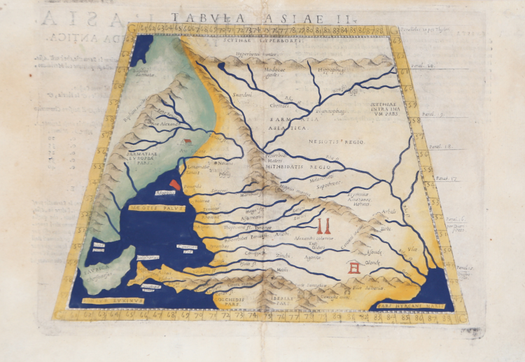
This Ptolemaic map focuses on a historical region steeped in legend, one of great importance in the early development of trade between Asia and Europe, the Silk Road region, between the Hyperborei and Caucus Mountains. It includes a portion of the Caspian Sea.
Those regions of eastern Europe which border the Black Sea are depicted, and named according to ancient kingdoms and peoples. The Black Sea has an interesting shape. Constantinople is not named, but the Bosphorus is. A number of references to the Scythians are noted, including the term ‘Hippophagi’, meaning eaters of horseflesh. While the Scythians were nomadic and depended entirely on the horse for transportation, they also used them as a source of food.
A number of other ancient civilizations are also referred to including the Sarmatians, the kingdom of Mithridatis, and the Amazons are named, but in the wrong region or Anatolia. Colchis is shown to the south of a very misshapen Anatolia. Numerous mountain ranges and river systems are shown in detail. Ruscelli was obviously familiar with reports of early explorers in the region, for he depicts and names many intriguing ancient monuments, including the famed ‘Columns of Alexander’. Most of these monuments are no longer extant, but their existence was vouchsafed by ancient historians.
Map taken from Geographia di Claudio Tolomeo edited by Girolamo Ruscelli, published in Venice in several editions between 1561 and 1598. The maps is based on the Geografia by Giacomo Gastaldi (1548), who probably also personally drew these maps, which were engraved by the brothers Livio and Giulio Sanuto.
The peculiarity of these maps is that they are engraved two for plate and subsequently cut; this is why the copper sign only appears on three sides of the map. Ruscelli's text and his maps are considered to be the best modern atlas up to the first version of Abraham Ortelius' Theatrum Orbis Terrarum (1570).
Only their widespread diffusion prevents a sustained evaluation in the antiquarian market. In fact, the work had a first edition in 1561, printed by Vincenzo Valgrisi who also edited the 1562 reprint. There are three editions signed by Giordano Ziletti (two in 1564 and one in 1574), while in 1597 it was published by the Calignani brothers. All these editions contain 64 plates. In 1598 and 1599 the two editions edited by Giuseppe Rosaccio and printed by the heirs of Melchior Sessa came to light. These last two editions include 69 plates; in fact, Rosaccio's map of the planisphere and continents has been added.
Etching and engraving with fine later hand colour, in good condition.
Girolamo RUSCELLI (Viterbo 1504 – Venezia 1566)
|
Ruscelli was editor of a revised and expanded edition of Ptolemy’s Geographia which was issued in Venice several times between 1561 and the end of the century. The newly engraved maps were based, generally, on those compiled by Giacomo Gastaldi for the Venice edition of 1548.
|