| Reference: | AL03OL |
| Author | Johannes VAN KEULEN |
| Year: | 1709 ca. |
| Zone: | Mediterranean Sea |
| Printed: | Amsterdam |
| Measures: | 1000 x 595 mm |
| Reference: | AL03OL |
| Author | Johannes VAN KEULEN |
| Year: | 1709 ca. |
| Zone: | Mediterranean Sea |
| Printed: | Amsterdam |
| Measures: | 1000 x 595 mm |
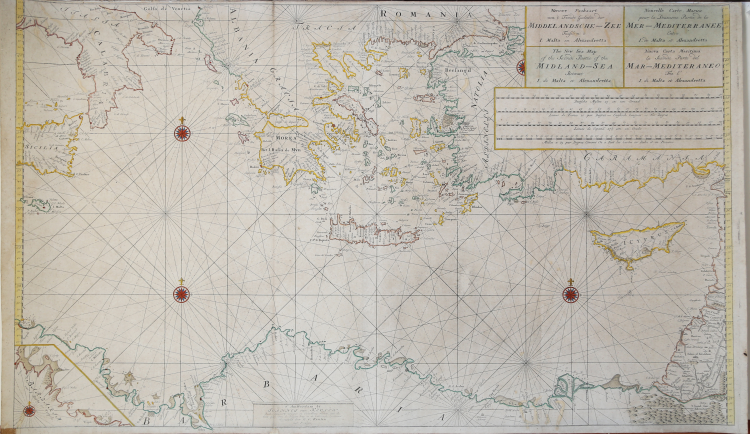
Nieuwe Paskaart van ‘t Tweede Gedeelte der Middelandsche-Zee Tusschen ‘t I. Malta en Alexandretta = The New Sea Map of the Seconde Partie of the Midland-Sea (...) = Nouvelle Carte Marine pour la Deuxiesme Partie de la Mer-Mediterranee (...) = Nuova Carta Maritima la Seconda Parte del Mar-Mediteraneo (...).
Etching and engraving, of the eastern part of the map, with fine original outline colour.
Nautical representation of the Eastern Mediterranean Sea; in the lcartouche at the top right, is shown in 4 languages but not in Spanish. At the bottom center reads: t 'Amsterdam by Ioannes van Keulen Boek-Zeeekard Verkooper en Graad boog maker aande Oost Zyde van de Nieuwe brug inde Gekroonde Lootsman Opgestelt door G: v: Keulen. met Privileges.
The first atlas Van Keulen in which we found the presence of paper is the third volume of the Zee-Fakkel, French edition of 1723: Le Nouveau & Grand Illuminant Flambeau de la Mer (...) par Nicolas Jansz Vooght, & Gerard van Keulen, Geomêtre , & Maistre en Mathematiques. Imprint in Amsterdam: par Jean Van Ceulen, Marchand Libraire de Cartes Marines. A ° 1723. Preserved at the Biblioteca Nacional in Madrid, the volume is quoted but not described by Koeman (see AN, IV, p. 345, Keu 103 D).
Johannes van Keulen's nautical collections were published for the first time in 1680, but the number of plates increased immediately; in 1683 - when parts I, II, III, and IV were published - the number increased to 116 maps. The most massive atlas, which appeared in 1695, includes 160 maps by Johannes van Keulen. Later, around 1709, Gerard van Keulen increased the number of plates to 185: the most obsolete ones were replaced by others; the tables were given a new numbering.
The book tradition foresaw that a nautical atlas should start with a map of the world; Van Keulen, not being in possession of a copper plate depicting the planisphere, resorted to the plates of Johannes de Ram, Claesz Visscher or other carvers. Gerard van Keulen, who succeeded his father in 1704, undertook a new activity in the cartographic sector; he expanded the nautical atlas with several of his maps and published it in its final form, in five parts similarly to the Zee-Fakkel, renumbering the plates.
|
S. Bifolco, "Mare Nostrum, Cartografia nautica a stampa del Mar Mediterraneo" (2020), pp. 170-171, tav. 75.
|
Johannes VAN KEULEN (1654 - 1715)
|
The Van Keulen dynasty of publishers, printers, booksellers, and cartographers produced the most comprehensive and up-to-date Dutch nautical atlases. Johannes van Keulen (1654–1715) founded a book and instrument business in Amsterdam in 1678 and in 1680 obtained the privilege of printing nautical guides and atlases from Holland and West Friesland. His first major work was the Nieuwe Lichtende Zee-Fakkel, illustrated by Jan Luyken, with maps drawn by Claes Jansz Vooght; five volumes were published between 1681 and 1684. Van Keulen also produced a Zee-Atlas ofte Water-werelt. The Van Keulen family continued to operate for nearly two centuries; Gerard (1678 - 1726) produced new editions of his father's works, numerous manuscript maps, and was appointed hydrographer to the Dutch East India Company (VOC) in 1706; his son Jan II van Keulen (1704 - 1770) took over the business in 1726 and published a new edition of the Asiatic volume of the Zee-Atlas; he was appointed cartographer to the VOC in 1743. After Jan II's death, his sons Cornelis Buijs and Gerard Hulst van Keulen ran the family business. Gerard (1733 - 1801) added a further volume to the Zee-Fakkel containing East India material derived from the VOC. Gerard, in addition to publishing the first nautical almanac in Dutch in 1788, was one of the three original members of the commission established by the Dutch government in 1787 to solve the problem of finding longitude at sea. Gerard's son, Jan III, was the last van Keulen to run the company.
|
|
S. Bifolco, "Mare Nostrum, Cartografia nautica a stampa del Mar Mediterraneo" (2020), pp. 170-171, tav. 75.
|
Johannes VAN KEULEN (1654 - 1715)
|
The Van Keulen dynasty of publishers, printers, booksellers, and cartographers produced the most comprehensive and up-to-date Dutch nautical atlases. Johannes van Keulen (1654–1715) founded a book and instrument business in Amsterdam in 1678 and in 1680 obtained the privilege of printing nautical guides and atlases from Holland and West Friesland. His first major work was the Nieuwe Lichtende Zee-Fakkel, illustrated by Jan Luyken, with maps drawn by Claes Jansz Vooght; five volumes were published between 1681 and 1684. Van Keulen also produced a Zee-Atlas ofte Water-werelt. The Van Keulen family continued to operate for nearly two centuries; Gerard (1678 - 1726) produced new editions of his father's works, numerous manuscript maps, and was appointed hydrographer to the Dutch East India Company (VOC) in 1706; his son Jan II van Keulen (1704 - 1770) took over the business in 1726 and published a new edition of the Asiatic volume of the Zee-Atlas; he was appointed cartographer to the VOC in 1743. After Jan II's death, his sons Cornelis Buijs and Gerard Hulst van Keulen ran the family business. Gerard (1733 - 1801) added a further volume to the Zee-Fakkel containing East India material derived from the VOC. Gerard, in addition to publishing the first nautical almanac in Dutch in 1788, was one of the three original members of the commission established by the Dutch government in 1787 to solve the problem of finding longitude at sea. Gerard's son, Jan III, was the last van Keulen to run the company.
|