| Reference: | AL01FR |
| Author | François Berthelot |
| Year: | 1700 ca. |
| Zone: | Mediterranean Sea |
| Printed: | Marsiglia |
| Measures: | 775 x 545 mm |
| Reference: | AL01FR |
| Author | François Berthelot |
| Year: | 1700 ca. |
| Zone: | Mediterranean Sea |
| Printed: | Marsiglia |
| Measures: | 775 x 545 mm |
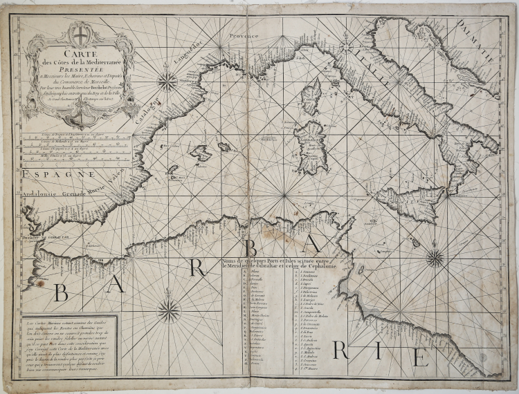
Etching, western part of the chart printed on two sheets, showing the imprint: Se Vend Chez Benoist M. d’Estampe sur le Port.
Beautiful example of the western part of this very rare French portolano.
Nautical chart based on the Berthelot map of 1693. The publishing imprint "Chez Benoist" is not otherwise known, therefore, it is not possible to establish the place of printing: the indication Merchant d'Estampe sur le Port was used both in Marseille and than in Toulon.
The box with the Noms de quelques Ports et Isles Situées entre le Meridien de Gibaltar et celuy de Cephalonie, a list of 49 islands in the western Mediterranean, is also unchanged.
At the bottom left, in a box, we read: Les Cartes Marines estant comme des Guides here indiquent les Routes ou Chemins que l'on doit Suire on ne scauroit take trop de soin pour les rendre fidelles au moins autant qu se se 'est dans cette consideration que j'ay Corrigé cette Cards de la Mediterranée en ce qu'elle avoit de plus defectureuse et comme j'ay pris le dessin de la rendre plus parfaite je prie ceux here y trouverent quelque defaut de vouloir bien me communiquer leurs remarques.
It is not clear whether this chart is an original work by Berthelot, or an authorized reprint that was sold "Chez Benoist" or, instead, a pirate edition.
Bibliografia: cfr. O. Chapuis, A la mer comme au ciel: Beautemps-Beaupré & la naissance de lhydrographie, Parigi, 1999, pp. 151-2.
|
S. Bifolco, "Mare Nostrum, Cartografia nautica a stampa del Mar Mediterraneo" (2020), pp. 254-255, tav. 118.
|
|
François Berthelot, cartographer, hydrographer, and professor was one of a number of Marseille-based authors who extended man's knowledge of the Mediterranean Sea during the late 17th and early to mid 18th century. Other authors in this category include Henri Michelot, Laurens Bremond, Nicolas Therin, Joseph Roux (Senior and Junior (b. 1725) ) and Jacques Ayrouard.
Among François Berthelot's accomplishments are a three sheet map of the Mediterranean (1693) on which he is self-described as professor and hydrographer at the city of Marseilles. Berthlot also published a text on the theory of navigation in 1691.
|
|
S. Bifolco, "Mare Nostrum, Cartografia nautica a stampa del Mar Mediterraneo" (2020), pp. 254-255, tav. 118.
|
|
François Berthelot, cartographer, hydrographer, and professor was one of a number of Marseille-based authors who extended man's knowledge of the Mediterranean Sea during the late 17th and early to mid 18th century. Other authors in this category include Henri Michelot, Laurens Bremond, Nicolas Therin, Joseph Roux (Senior and Junior (b. 1725) ) and Jacques Ayrouard.
Among François Berthelot's accomplishments are a three sheet map of the Mediterranean (1693) on which he is self-described as professor and hydrographer at the city of Marseilles. Berthlot also published a text on the theory of navigation in 1691.
|