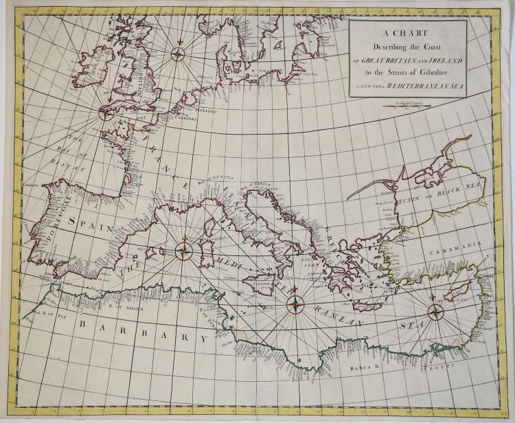

| Reference: | VR48EN |
| Author | John SENEX |
| Year: | 1728 |
| Zone: | Mediterranean Sea |
| Printed: | London |
| Measures: | 610 x 550 mm |
| Reference: | VR48EN |
| Author | John SENEX |
| Year: | 1728 |
| Zone: | Mediterranean Sea |
| Printed: | London |
| Measures: | 610 x 550 mm |
Etching, with fine later hand colour, very good condition.
Taken from: Atlas maritimus & commercialis, or, A general view of the world, so far as relates to trade and navigation: describing all the coasts, ports, harbours, and noted rivers ... : to which are added sailing directions for all the known coasts and islands on the globe, with a set of sea charts, some laid down after Mercator, but the greater part according to a new globular projection adapted for measuring distances...by scale and compass...the use of the projection justified by Dr. Halley. To which are subjoin'd two large hemispheres on the plane of the equinoctial containing all the stars in the Britannic catalogue: of great use to sailors for finding the latitude in the night. London: For J. & J. Knapton, W. & J. Innys [Etc.], 1728.
This very rare work was born from the collaboration of some of the leading cartographers and scientists of the period, including Sir Edmund Halley, John Senex, Nathaniel Cutler, Steven Parker and Daniel Defoe.
The Atlas maritimus & commercialis was designed by Senex and Harris in an attempt to compete with Mount & Page's hugely popular The English Pilot; however, despite the collaboration was of the highest scientific level, the atlas did not have great commercial success.
Bibliografia: Mare Nostrum, a historic voyage across the Mediterranean Sea, Lussemburgo, 2003, p. 33; National Maritime Museum, Catalogue of the Library - Vol. Three, Atlas & Cartography, Londra, 1971, pp. 400-401, n. 341(22); R. Shirley, Maps in the Atlases of the British Library, Londra, 2004, pp. 1177-78, M.Hall -1a (22); cfr. The Compleat Plattmaker: essays on Chart, Map and Globe Making in England in the Seventeenth and Eighteenth Centuries, Berkeley, 1978.
|
S. Bifolco, "Mare Nostrum, Cartografia nautica a stampa del Mar Mediterraneo" (2020), p. 215, tav. 98.
|
John SENEX (Londra, 1678 – 1740)
|
John Senex (1678 - 1740) was one of the most important English map makers and publishers of the first half of the 18th century. He was first apprenticed to the prominent bookseller and publisher Robert Clavell, but his association with Jeremiah Seller and Charles Price led him to a career as a surveyor, cartographer, globe maker, and map publisher and seller. His contribution to the development of the British map trade was such that he was honored (1728) by election to membership in the Royal Society, sponsored by some of the greatest scientists of the period. His early career was relatively unhappy; the society with Jeremiah Seller and Charles Price lasted only 3 years and ended in bankruptcy, in 1706. From then on, until about 1710, he worked only with Price, from whom he learned and refined the art of engraving. The two devoted themselves to the design of an atlas of the world, competing with that of rival Herman Moll. When the partnership ended, Senex worked on his own cartographic collection, which was published as The English Atlas (1714); it was one of the most successful atlases of the century, being reprinted until 1760. Senex also worked as a semi-official engraver for the Royal Society, for its printer William Taylor, and for prominent figures within it, including Edmund Halley and William Whiston. He then published several important scientific maps, most notably Halley and Whiston's eclipse maps (1715 and 1724). These scientific contacts of his provided him with essential and innovative technical elements, useful for his wide range of terrestrial and celestial globes. With this solid foundation, Senex became the most prestigious map publisher of the time. Upon his death (1740) the printing press was directed by his widow Mary, who continued the business until 1755, when she retired; William Herbert and Robert Sayer acquired the rights to the cartographic works, while James Ferguson took over the part dealing with globes.
|
|
S. Bifolco, "Mare Nostrum, Cartografia nautica a stampa del Mar Mediterraneo" (2020), p. 215, tav. 98.
|
John SENEX (Londra, 1678 – 1740)
|
John Senex (1678 - 1740) was one of the most important English map makers and publishers of the first half of the 18th century. He was first apprenticed to the prominent bookseller and publisher Robert Clavell, but his association with Jeremiah Seller and Charles Price led him to a career as a surveyor, cartographer, globe maker, and map publisher and seller. His contribution to the development of the British map trade was such that he was honored (1728) by election to membership in the Royal Society, sponsored by some of the greatest scientists of the period. His early career was relatively unhappy; the society with Jeremiah Seller and Charles Price lasted only 3 years and ended in bankruptcy, in 1706. From then on, until about 1710, he worked only with Price, from whom he learned and refined the art of engraving. The two devoted themselves to the design of an atlas of the world, competing with that of rival Herman Moll. When the partnership ended, Senex worked on his own cartographic collection, which was published as The English Atlas (1714); it was one of the most successful atlases of the century, being reprinted until 1760. Senex also worked as a semi-official engraver for the Royal Society, for its printer William Taylor, and for prominent figures within it, including Edmund Halley and William Whiston. He then published several important scientific maps, most notably Halley and Whiston's eclipse maps (1715 and 1724). These scientific contacts of his provided him with essential and innovative technical elements, useful for his wide range of terrestrial and celestial globes. With this solid foundation, Senex became the most prestigious map publisher of the time. Upon his death (1740) the printing press was directed by his widow Mary, who continued the business until 1755, when she retired; William Herbert and Robert Sayer acquired the rights to the cartographic works, while James Ferguson took over the part dealing with globes.
|