| Reference: | VR45EN |
| Author | Herman MOLL |
| Year: | 1720 ca. |
| Zone: | Mediterranean Sea |
| Printed: | London |
| Measures: | 430 x 300 mm |
| Reference: | VR45EN |
| Author | Herman MOLL |
| Year: | 1720 ca. |
| Zone: | Mediterranean Sea |
| Printed: | London |
| Measures: | 430 x 300 mm |
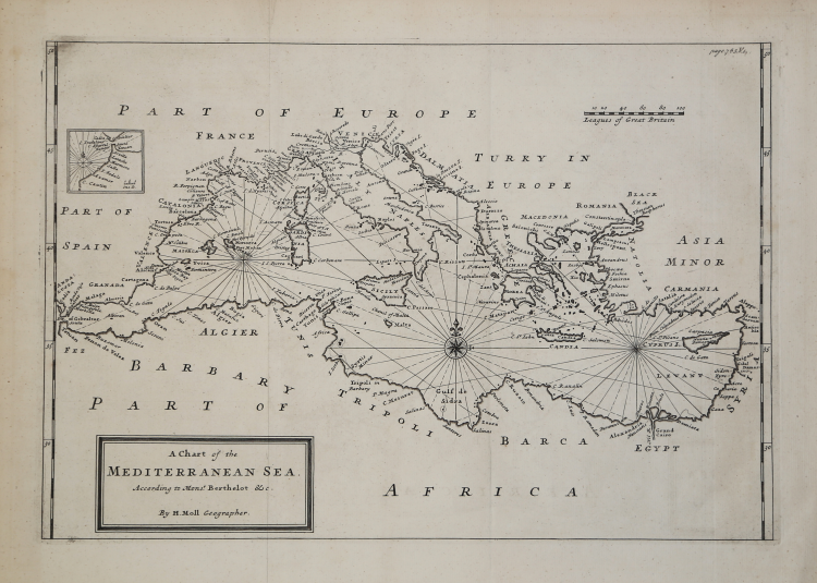
Etching, 300x430 mm, signed in the cartouche with the title: By H. Moll Geographer.
Nautical chart by Hermann Moll, who calls himself a "geographer" and, therefore, could be the compiler, as well as the engraver, of the work. There are copies of the map that bear the imprint below: Printed for The Bowles in St. Pauls Church yard in John Bowles in the Black Horse in Cornhill; others present, at the top right, page number 753. V1.
At the top left, we find a small cartouche depicting Gibraltar, which had just been given to England with the Treaty of Utrecht of 1713. The map is not inserted in any of the numerous Moll atlases described by Shirley.
Herman Moll (1654 - 1732) was one of the most important publishers dedicated to the trade of maps in England between the end of the seventeenth and the beginning of the eighteenth century. It seems likely that it came from Germany, perhaps from Bremen, and that it was in London as early as 1678. The few biographical information is deduced from the remarkable production of cartographic material, the result of the activity to which he dedicated himself - as was the custom at the time - as an engraver, draftsman or publisher.
Bibliografia: cfr. National Maritime Museum, Catalogue of the Library - Vol. Three, Atlas & Cartography, Londra, 1971, pp. 453-458; cfr. The Compleat Plattmaker: essays on Chart, Map and Globe Making in England in the Seventeenth and Eighteenth Centuries, Berkeley, 1978; cfr. S. Tyacke, Chartmaking in England and Its Context, 1500 - 1600, in “History of Cartography”, Chicago, 2007, pp. 1722 – 1753.
|
S. Bifolco, "Mare Nostrum, Cartografia nautica a stampa del Mar Mediterraneo" (2020), p. 214, tav. 97.
|
|
Herman Moll came to London in about 1678 and worked as an engraver for other publishers, such as Moses Pitt, Greenville Collins. John Adair, and Seller & Price, but soon set up his own business publishing atlases and also separate maps of all parts of the world. His work was varied, ranging from miniature maps to large very decorative wall maps. The first maps engraved by Moll in his own right were prepared for the atlas volume accompanying Sir Jonas Moore’s New System Of The Mathematicks …, in which he began to develop his characteristic engraving style.
Maps in Moll’s large folio atlas, The World Described are clearly printed with large cartouches, enclosing the title and dedication and often with large vignettes. This atlas contained one of the largest world maps of the early eighteenth century to appear in atlas form. Published in 1724 the map is somewhat outdated (despite its author’s claims), showing California as an Island long after the French maps of around 1700 had depicted it as a peninsula. Perhaps his most famous map is the New and Exact Map of the Dominions of the King of Great Britain on ye Continent of North America, depicting the English colonies along the east coast. The map is more popularly called the “Beaver Map”, after the attractive vignette scene showing beavers building dams.
Jonathan Swift, it is said, referred to Moll’s maps in the writing of Gulliver’s Travels, thereby adding greater credibility to his story by ensuring the location of the islands visited by Gulliver could not be disputed.
Moll’s other works include the Atlas Manuale (1709), New and Complete Atlas (1719), the Atlas Minor (1729) and Atlas Geographus (1711-17) in five volumes.
Moll also published a fine series of county maps, in the New Description of England, published in 1724. The maps are famous for their side panels with drawings of architectural remains from the counties. His work was much copied by other publishers and he enjoyed a high reputation.
|
|
S. Bifolco, "Mare Nostrum, Cartografia nautica a stampa del Mar Mediterraneo" (2020), p. 214, tav. 97.
|
|
Herman Moll came to London in about 1678 and worked as an engraver for other publishers, such as Moses Pitt, Greenville Collins. John Adair, and Seller & Price, but soon set up his own business publishing atlases and also separate maps of all parts of the world. His work was varied, ranging from miniature maps to large very decorative wall maps. The first maps engraved by Moll in his own right were prepared for the atlas volume accompanying Sir Jonas Moore’s New System Of The Mathematicks …, in which he began to develop his characteristic engraving style.
Maps in Moll’s large folio atlas, The World Described are clearly printed with large cartouches, enclosing the title and dedication and often with large vignettes. This atlas contained one of the largest world maps of the early eighteenth century to appear in atlas form. Published in 1724 the map is somewhat outdated (despite its author’s claims), showing California as an Island long after the French maps of around 1700 had depicted it as a peninsula. Perhaps his most famous map is the New and Exact Map of the Dominions of the King of Great Britain on ye Continent of North America, depicting the English colonies along the east coast. The map is more popularly called the “Beaver Map”, after the attractive vignette scene showing beavers building dams.
Jonathan Swift, it is said, referred to Moll’s maps in the writing of Gulliver’s Travels, thereby adding greater credibility to his story by ensuring the location of the islands visited by Gulliver could not be disputed.
Moll’s other works include the Atlas Manuale (1709), New and Complete Atlas (1719), the Atlas Minor (1729) and Atlas Geographus (1711-17) in five volumes.
Moll also published a fine series of county maps, in the New Description of England, published in 1724. The maps are famous for their side panels with drawings of architectural remains from the counties. His work was much copied by other publishers and he enjoyed a high reputation.
|