| Reference: | VR27OL |
| Author | Gerard VAN KEULEN |
| Year: | 1743 ca. |
| Zone: | Mediterranean Sea |
| Printed: | Amsterdam |
| Measures: | 1970 x 600 mm |
| Reference: | VR27OL |
| Author | Gerard VAN KEULEN |
| Year: | 1743 ca. |
| Zone: | Mediterranean Sea |
| Printed: | Amsterdam |
| Measures: | 1970 x 600 mm |
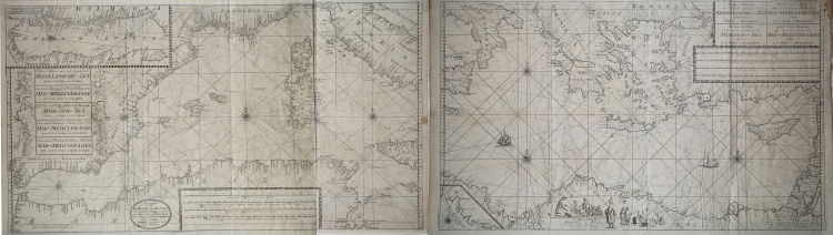
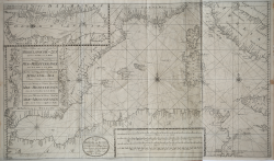
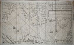
Neuwe Paskaart van ‘t Eerste Gedeelte der Middelansche-Zee tusschen ‘t I. Cadix en ‘t I. Malta = Nouvelle Carte Marine pour la Premier Partie de la Mer-Mediterranee (...) = The New Sea Map of the First Part of the Midland-Sea (...) = Nueva Carta Maritima la Primera Parte del Mar-Mediteraneo (...) = Nuova Carta Maritima la Prima Parte del Mar- Mediteraneo & Nieuwe Paskaart van ‘t Tweede Gedeelte der Middelandsche-Zee Tusschen ‘t I. Malta en Alexandretta = The New Sea Map of the Seconde Partie of the Midland-Sea (...) = Nouvelle Carte Marine pour la Deuxiesme Partie de la Mer-Mediterranee (...) = Nuova Carta Maritima la Seconda Parte del Mar-Mediteraneo (...).
Etching and engraving, printed on two sheets, respectively 600x900 and 595x1000
Nautical representation of the Mediterranean Sea, divided into the western and eastern parts.
The title of the western part, contained in the large decorative cartouche on the left, is repeated in 5 languages: Dutch, French, English, Spanish and Italian. At the bottom of the page is the editorial imprint: t 'Amsterdam by Ioannes van Keulen Boek Zeeekard Verkooper en Graad boog maker aan de Oost Zyde Vande Nieuwe Brug inde. The title of the eastern part, in the large cartouche at the top right, is shown in 4 languages but not in Spanish. At the bottom center reads: t 'Amsterdam by Ioannes van Keulen Boek-Zeeekard Verkooper en Graad boog maker aande Oost Zyde van de Nieuwe brug inde Gekroonde Lootsman Opgestelt door G: v: Keulen. met Privileges.
It is a variant of the previous map of the Van Keulen's - signed by Johannes I Van Keulen and by his son Gerard and datable to 1709 - which sees the changes and slightly reduced plates (of about 10 mm): decorative elements are added to the sheet on the right, where a group of figures in oriental clothes is drawn surrounding the cartouche; in the sea two ships appear off the coast of Malta and Cyprus. According to Nils Persson (see Loose printed Sea Charts published by Van Keulen, p. 177) the maps are not part of any nautical collection, but were sold individually.
In the upper left corner of the western map we find, out of scale in a scroll, the representation of the Adriatic Sea; in the eastern sheet, below on the right, we find the detail of the Libyan coast: Barbaria van I. Zerby tot Tripoli.
The first version of the maps belongs to the third volume of the Zee-Fakkel, of which it is one of the tables added in 1709 by Gerard van Keulen. Signed by Johannes Van Keulen (1654 - 1715), the map is completed and printed by his son Gerard (1678 - 1726), whose name is shown in both cartouches.
Although, according to Koeman, the map would be printed only in 1734 (see AN, IV, p. 341, Keu 95 and V, p. 203), Irene Jacobs confirms that they belongs to the Zee-Fakkel update of 1709 ( see Charts in Zee-Fakkel and Zee-Atlas, p. 204).
The first atlas Van Keulen in which we found the presence of paper is the third volume of the Zee-Fakkel, French edition of 1723: Le Nouveau & Grand Illuminant Flambeau de la Mer (...) par Nicolas Jansz Vooght, & Gerard van Keulen, Geomêtre , & Maistre en Mathematiques. Imprint in Amsterdam: par Jean Van Ceulen, Marchand Libraire de Cartes Marines. A ° 1723. Preserved at the Biblioteca Nacional in Madrid, the volume is quoted but not described by Koeman (see AN, IV, p. 345, Keu 103 D).
Johannes van Keulen's nautical collections were published for the first time in 1680, but the number of plates increased immediately; in 1683 - when parts I, II, III, and IV were published - the number increased to 116 maps. The most massive atlas, which appeared in 1695, includes 160 maps by Johannes van Keulen. Later, around 1709, Gerard van Keulen increased the number of plates to 185: the most obsolete ones were replaced by others; the tables were given a new numbering.
The book tradition foresaw that a nautical atlas should start with a map of the world; Van Keulen, not being in possession of a copper plate depicting the planisphere, resorted to the plates of Johannes de Ram, Claesz Visscher or other carvers. Gerard van Keulen, who succeeded his father in 1704, undertook a new activity in the cartographic sector; he expanded the nautical atlas with several of his maps and published it in its final form, in five parts similarly to the Zee-Fakkel, renumbering the plates.
Probably this version is printed by the heirs of Gerard Van Keulen; Jan II van Keulen (1704 - 1770) took over the business in 1726 and published a new edition of the Asian volume of the Zee-Atlas; was appointed cartographer of the VOC in 1743. After the death of Jan II, his sons Cornelis Buijs and Gerard Hulst van Keulen managed the family business which, after the death of Cornelis in 1788, was taken over by Gerard (1733 - 1801). If the previous nautical map circulated in the editions of the Zee-Fakkel until around 1740, we can assume that this amended version is later than 1743.
Bibliografia: C. Koeman, Atlantes Neerlandici: Bibliography of Terrestrial, Maritime and Celestial Atlases and Pilot Books Published in the Netherlands up to 1880 Vol. IV, Amsterdam 1970, pp. 384-385, nn. 204, 205; cfr. R. Shirley, Maps in the Atlases of the British Library, Londra, 2004, pp. 1200-1213; N. Perrson, Loose printed Sea Charts published by Van Keulen, in “The Van Keulen Cartography”, Amsterdam 1680-1885, Leida, 2005, pp. 177-178, nn. 143, 153.
|
S. Bifolco, "Mare Nostrum, Cartografia nautica a stampa del Mar Mediterraneo" (2020), pp. 178-179, tav. 79.
|
Gerard VAN KEULEN (1678 - 1726)
|
The Van Keulen dynasty of publishers, printers, booksellers, and cartographers produced the most comprehensive and up-to-date Dutch nautical atlases. Johannes van Keulen (1654–1715) founded a book and instrument business in Amsterdam in 1678 and in 1680 obtained the privilege of printing nautical guides and atlases from Holland and West Friesland. His first major work was the Nieuwe Lichtende Zee-Fakkel, illustrated by Jan Luyken, with maps drawn by Claes Jansz Vooght; five volumes were published between 1681 and 1684. Van Keulen also produced a Zee-Atlas ofte Water-werelt. The Van Keulen family continued to operate for nearly two centuries; Gerard (1678 - 1726) produced new editions of his father's works, numerous manuscript maps, and was appointed hydrographer to the Dutch East India Company (VOC) in 1706; his son Jan II van Keulen (1704 - 1770) took over the business in 1726 and published a new edition of the Asiatic volume of the Zee-Atlas; he was appointed cartographer to the VOC in 1743. After Jan II's death, his sons Cornelis Buijs and Gerard Hulst van Keulen ran the family business. Gerard (1733 - 1801) added a further volume to the Zee-Fakkel containing East India material derived from the VOC. Gerard, in addition to publishing the first nautical almanac in Dutch in 1788, was one of the three original members of the commission established by the Dutch government in 1787 to solve the problem of finding longitude at sea. Gerard's son, Jan III, was the last van Keulen to run the company.
|
|
S. Bifolco, "Mare Nostrum, Cartografia nautica a stampa del Mar Mediterraneo" (2020), pp. 178-179, tav. 79.
|
Gerard VAN KEULEN (1678 - 1726)
|
The Van Keulen dynasty of publishers, printers, booksellers, and cartographers produced the most comprehensive and up-to-date Dutch nautical atlases. Johannes van Keulen (1654–1715) founded a book and instrument business in Amsterdam in 1678 and in 1680 obtained the privilege of printing nautical guides and atlases from Holland and West Friesland. His first major work was the Nieuwe Lichtende Zee-Fakkel, illustrated by Jan Luyken, with maps drawn by Claes Jansz Vooght; five volumes were published between 1681 and 1684. Van Keulen also produced a Zee-Atlas ofte Water-werelt. The Van Keulen family continued to operate for nearly two centuries; Gerard (1678 - 1726) produced new editions of his father's works, numerous manuscript maps, and was appointed hydrographer to the Dutch East India Company (VOC) in 1706; his son Jan II van Keulen (1704 - 1770) took over the business in 1726 and published a new edition of the Asiatic volume of the Zee-Atlas; he was appointed cartographer to the VOC in 1743. After Jan II's death, his sons Cornelis Buijs and Gerard Hulst van Keulen ran the family business. Gerard (1733 - 1801) added a further volume to the Zee-Fakkel containing East India material derived from the VOC. Gerard, in addition to publishing the first nautical almanac in Dutch in 1788, was one of the three original members of the commission established by the Dutch government in 1787 to solve the problem of finding longitude at sea. Gerard's son, Jan III, was the last van Keulen to run the company.
|