| Reference: | VR04OL |
| Author | Pieter GOOS |
| Year: | 1680 ca. |
| Zone: | Europe |
| Printed: | Amsterdam |
| Measures: | 890 x 715 mm |
| Reference: | VR04OL |
| Author | Pieter GOOS |
| Year: | 1680 ca. |
| Zone: | Europe |
| Printed: | Amsterdam |
| Measures: | 890 x 715 mm |
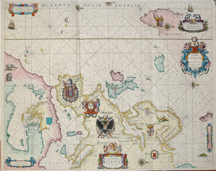
Etching and engraving, 1650 circa, 715x890 mm. Imprint at upper right: Seyn nu te Bekoomen by Iohannus van Keulen.
Magnificient example, printed on contemporary laid paper, with margins, contemporary old coloured, in excellent condition
This is a variant of the second state of Willem Janszoon Blaeu's rare sea chart of Europe, c.1621, now published by P. Goos. The 2nd state described by Schilder IV, 45.2: the 4th line of the title cartouche says: "Nieulijcx aldus uytgegeven", our copy says: "Nieulyez aldus uytgegeven".
The chart was highly influential and was copied by Anthonie Jacobz and Justus Danckerts, as well as by Blaeu's own grandchildren Willem, Pieter and Joan.
Goos made the only re-issue of the original Blaeu plate, and Gunter Schilder dates this state between 1650 and 1666.
The text in the title cartouche, still crowned by the printer's mark of Blaeu, has been replaced and a new imprint has been placed in a new richly decorated cartouche in Greenland. The chart is oriented to the west. It shows the seacoasts of Europe from Novaya Zemlya and the Gulf of Sydra in the east, and the Azores and the west coast of Greenland in the west. In the north the chart extends to the northern coast of Spitsbergen, and in the south to the Canary Islands. The eastern part of the Mediterranean is included in the North African interior (Schilder).
Magnificently decorated, there are richly detailed European coats of arms, scale cartouches in the corners, several ships in the waters, a pair of native people in Greenland, and a number of animals portrayed on land, including polar bears and elephants.
Only 5 copies are listed in public libraries, three on vellum and two on paper. The three copies on vellum are in the Badische Landesbibliothek, Karlsruhe , Kungl. Biblioteket, Stockholm and The Library of Congress, Washington. The two copies on paper are in the Bibliothèque Nationale, Paris.
Bibliografia: cfr. G. Schilder, Willem Janszoon Blaeu’s Map of Europe (1606), A Recent Discovery in England, in “Imago Mundi”, 28 (1976), pp. 9–20; G. Schilder, Monumenta Cartographica Neerlandica, Vol. IV, Alphen aan den Rijn, 1993, pp. 100-102, n. 45.2; K. Stopp - H. Langel, Katalog der alten Landkarten in der Badischen Landesbibliothek Karlsruhe, Karlsruhe, 1974, p. 34; cfr. D. de Vries, G. Schilder, W. Morzer Bruyns, P. van Iterson, I. Jacobs, The Van Keulen Cartography Amsterdam 1680-1885, Alphen aan den Rijn, 2005.
|
S. Bifolco, "Mare Nostrum, Cartografia nautica a stampa del Mar Mediterraneo" (2020), pp. 146-147, tav. 61.
|
|
Abraham Goos was a noted engraver in Amsterdam who prepared plates for many maps published in well-known atlases of his time including Speed's A Prospect ofthe Most Famous Parts of the World (1627) and the 1632 edition of Speed's Atlas.
He was related to the Hondius family by whom he was also employed as an engraver.
In 1616 he issued a book of maps, the Nieuw Nederlandtsh Caertboeck (4to) which was re-issued in 1619 and 1625.
His son, Pieter, continued and extended his father's business and became one of the group of well-known engravers of sea charts active in Amsterdam in the middle years of the seventeenth century.
In common with Colom, Doncker and Jacobsz he published a pilot guide, the Zee-Spiegel, basing it on plates obtained from Jacobsz. This went through many editions in different languages under the startling titles so popular at the time.
In addition to publishing his Zee-Spiegel in the usual Parts 1 and II (Europe and Atlantic coasts) and Part III (Mediterranean) he broke new ground in preparing Parts IV and V, covering charts and sailing directions for the coasts of the West Indies and West Africa. The later editions of the Zee Atlas were published by his widow who eventually sold the publishing rights of the Atlas and of the Zee-Spiegel to Jacobus Robijn.
|
|
S. Bifolco, "Mare Nostrum, Cartografia nautica a stampa del Mar Mediterraneo" (2020), pp. 146-147, tav. 61.
|
|
Abraham Goos was a noted engraver in Amsterdam who prepared plates for many maps published in well-known atlases of his time including Speed's A Prospect ofthe Most Famous Parts of the World (1627) and the 1632 edition of Speed's Atlas.
He was related to the Hondius family by whom he was also employed as an engraver.
In 1616 he issued a book of maps, the Nieuw Nederlandtsh Caertboeck (4to) which was re-issued in 1619 and 1625.
His son, Pieter, continued and extended his father's business and became one of the group of well-known engravers of sea charts active in Amsterdam in the middle years of the seventeenth century.
In common with Colom, Doncker and Jacobsz he published a pilot guide, the Zee-Spiegel, basing it on plates obtained from Jacobsz. This went through many editions in different languages under the startling titles so popular at the time.
In addition to publishing his Zee-Spiegel in the usual Parts 1 and II (Europe and Atlantic coasts) and Part III (Mediterranean) he broke new ground in preparing Parts IV and V, covering charts and sailing directions for the coasts of the West Indies and West Africa. The later editions of the Zee Atlas were published by his widow who eventually sold the publishing rights of the Atlas and of the Zee-Spiegel to Jacobus Robijn.
|