
| Reference: | S48558 |
| Author | Frans Verhaer [Franciscus Haraeus] |
| Year: | 1624 |
| Zone: | Geographia Sacra |
| Printed: | Antwerpen |
| Measures: | 345 x 270 mm |
| Reference: | S48558 |
| Author | Frans Verhaer [Franciscus Haraeus] |
| Year: | 1624 |
| Zone: | Geographia Sacra |
| Printed: | Antwerpen |
| Measures: | 345 x 270 mm |
- LVMEN HISTORIARVM per OCCIDENTEM ex conatibus FRAN. HARÆI. Antuerpiæ.
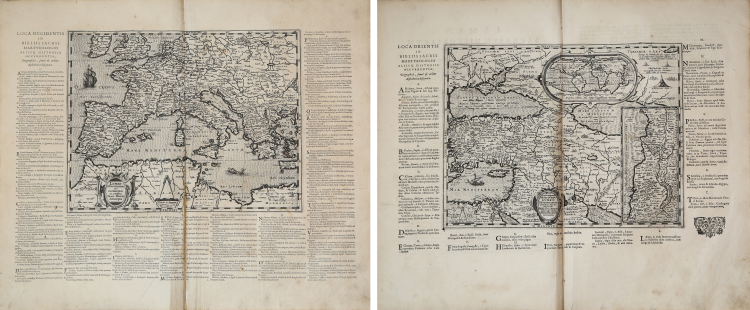
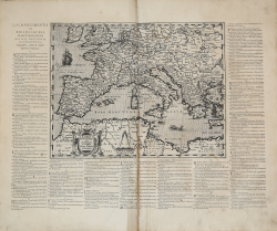
A map of the Mediterranean Sea, also covering the southern parts of the British Isles across to Crete. Map with on three sides alphabetical list of toponyms in letterpress: Loca Orientis In Bibliis Sacris Martyrologio Aliisq. Historii Occurentia.
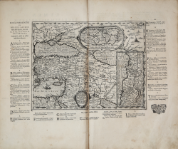
- LVMEN HISTORIARVM per Orientem "illustrandis Biblijs sacris, Martyrologio, et alijs multis.
Map of the eastern old world with inset world map: "Typus Orbis ad Investigandum Ophir" (8 x17,5 cm) and inset map of the Holy Land: "Iudaeae amplior descriptio" (17 x 8 cm). Map with on three sides alphabetical list of toponyms in letterpress: "Loca Orientis In Bibliis Sacris Martyrologio Aliisq. Historii Occurentia".
This is a very rare pair of maps depicting the “Holy Geography” of the Old World drawn by Frans Verhaer and published by Balthasar Moretus in the posthumous edition of Abraham Ortelius’ Parergon in 1624.
Franciscus Haraeus, Latinized form of Frans Verhaer, was a theologian, historian and cartographer from the Netherlands. Haraeus was one of several Dutch clergymen who, around the end of the 17th century, made important contributions to the young science of cartography. He was one of three cartographers from the Spanish Netherlands who kept the craft alive after the exodus of many, due to religious persecution, that occurred at the turn of the 17th century. In 1614 he published a six-stringed map entitled Novus typus orbis ipsus globus, ex Analemmate Ptolomaei diductus. This is one of the first cases of a thematic map, as it shows the dispersion of Christianity and Islam at the time, using the cartographic symbols developed by Jodocus Hondius in his Designatio Orbis Christiani (1607). In 1624 he signed the Lumen Historiarum per Orientem and the Lumen Historiarum per Occidentem, published by Balthasar Moretus in the new, posthumous edition of the Parergon of the Theatrum Orbis Terrarum by Abraham Ortelius, who acknowledged Haraeus as its author. The two maps were conceived by Hareus as a complete guide to “Holy Geography”.
The two sheets measure 345x270 and 355x270 mm respectively for the engraved part, which is surrounded by a legend printed with typographic characters.
Beautiful proofs, printed on contemporary laid paper, defects on the central fold of the western map, otherwise in excellent condition.
Bibliografia
Van der Krogt 3, 0821H:31; Van den Broecke, 184, 185.
Frans Verhaer [Franciscus Haraeus] Utrecht 1555 circa - Leuven 1631
|
Franciscus Haraeus (Latinised form of Franciscus Verhaer; also known as Frans Verhaer), was a theologian, historian, and cartographer from the Low Countries. He is best known for his history of the origins of the Dutch Revolt, written from a Catholic perspective but without polemical bias. He was one of the first cartographers to make thematic maps and globes. Haraeus first attended the Latin school of the Brethren of the Common Life in Utrecht and subsequently studied theology at the University of Louvain under Thomas Stapleton and Joannes Molanus. He was ordained a Roman Catholic priest at an early age, probably in 1578. He was appointed as a professor of rhetoric at the recently established University of Douai where he also obtained a Licentiate of Theology. In 1581 he accompanied the papal legate Antonio Possevino on an embassy to John III of Sweden and Ivan the Terrible. Back in the Dutch Republic he became a canon at St. John's Cathedral ('s-Hertogenbosch), later dean in Dunkirk and professor of theology at Tongerlo Abbey. In 1604-1609 he worked as a priest in Utrecht where he was in contact with Buchelius. After 1609 he moved permanently to the Spanish Netherlands where he became the rector of a nunnery in Antwerp, before becoming a canon in Namur in 1617, and after 1621 in Leuven. He died in the latter city on 11 January 1631, and was buried in the St. Peter Church in Leuven, near the tomb of Thomas Stapleton. Haraeus compiled a large number of hagiographies. However, his historical works of longer lasting import concerned the first part of the Eighty Years' War through which he had lived himself. He clearly took the side of king Philip II of Spain against William the Silent, giving his work a clear bias. His first publication in this field was Onpartijdighe Verklaringhe der oorsaken der Nederlantsche oorloghs sedert 't jaer 1566 tot 1608 (Antwerp 1612). This provoked a critical response from the Dutch judge François Vranck. Meanwhile, Haraeus had already started on his major history: Annales ducum seu principum Brabantiae totiusque Belgii tomi tres: quorum primo solius Brabantiae, secundo Belgii uniti principum res gestae, tertio Belgici tumultus usque ad inductas anno MDCIX pactas, enarrantur (Antwerp 1623). This work was well received in the Spanish Netherlands where it was long a "best seller". The third volume was reworked by its author, but this version only exists in manuscript; it was never printed.
Haraeus was one of several clergymen from the Netherlands who around the turn of the 17th century made important contributions to the young science of map-making. He was one of the three cartographers in the Spanish Netherlands who kept the craft of globe-making alive there after the exodus of many cartographers around the turn of the 17th century. In 1614 he published a six-gore map entitled Novus typus orbis ipsus globus, ex Analemmate Ptolomaei diductus. This was one of the first instances of a thematic map as it showed the dispersion of Christianity and Islam at the time, using map symbols developed by Jodocus Hondius in his Designatio Orbis Christiani (1607). In 1624 a map entitled Lumen Historiarum per Orientem was published by Balthasar Moretus as part of a new edition of Ortelius' Parergon of Theatrum Orbis Terrarum which recognized Haraeus as its maker. This map was part of a set of two made earlier by Haraeus and designed as a comprehensive guide to sacred geography.
As a final example, Haraeus Geographica restituta per globi trientes (1618) shows the world in three globe-gores, with insets showing a map representing the 2nd-century worldview of Ptolemy at lower right, and a legend for the map in the lower center, explaining symbols which identify religious populations (a cross for Christian regions, a crescent for Islam, and a slanted arrow for barbarians).
|