
| Reference: | S42888 |
| Author | Anonimo |
| Year: | 1860 ca. |
| Zone: | Pesaro, Urbino |
| Measures: | 570 x 785 mm |
| Reference: | S42888 |
| Author | Anonimo |
| Year: | 1860 ca. |
| Zone: | Pesaro, Urbino |
| Measures: | 570 x 785 mm |
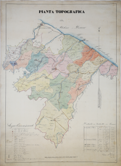
Beautiful handwritten map depicting the Province of Urbino and Pesaro, with accurate description of the Districts of Urbino, Gubbio, Pesaro, Fano and Senigallia, finely watercolored borders and respective territorial sections.
Devoid of editorial data, the map depicts the Province of Urbino and Pesaro, established in 1860.
The province of Pesaro and Urbino roughly corresponds to that of the ancient Duchy of Urbino, except for Senigallia (now in the province of Ancona), Gubbio (now in Umbria) and the seven secessionist municipalities of Val Marecchia passed to Emilia-Romagna following the referendum of 2009. In the administrative organization of the State of the Church, the provincial territory coincided with that of the apostolic delegation of Urbino and Pesaro, then became, in 1860, the province of Urbino and Pesaro, one of the six provinces in which the Marche were then divided. In view of the unification of Italy, the territorial structure of the Marches was reformed with the decree Rattazzi (decree n. 4495, December 22, 1860[9]), which reduced the number of provinces to four and also ordered the renaming of the institution in the province of Pesaro and Urbino.
The original province included the territory of 9 municipalities of the upper valley of the river Marecchia and Conca Valley, as part of Montefeltro and the Duchy of Urbino, which, on July 6, 1816, was included motu proprio by Pius VII in the delegation of Urbino and Pesaro.
Watercolor ink drawing in excellent condition.
Anonimo
Anonimo