| Reference: | s31220 |
| Author | Justus DANKERTS |
| Year: | 1680 |
| Zone: | Rome |
| Printed: | Amsterdam |
| Measures: | 365 x 232 mm |
| Reference: | s31220 |
| Author | Justus DANKERTS |
| Year: | 1680 |
| Zone: | Rome |
| Printed: | Amsterdam |
| Measures: | 365 x 232 mm |
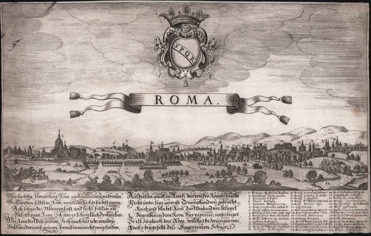
Rare perspective view of the city seen from Monte Mario.
The panroama is taken from the view engraved by Dominique Barriere in 1649, to which it is in counterpart.
At the top, above the title, we see the coat of arms SPQR surmounted by a crown. At the bottom left 12 lines of text and at the right a 42-number legend. Only St. Peter's is recognisable (not even Castel Sant'Angelo is recognisable) from which we deduce that the view was copied and not made from life; this is confirmed by the representation in counterpart. The prototype from which it is taken is the view engraved by Dominique Barriere in 1649, with which, moreover, the numbers and items in the legend also coincide. De Jonghe had already made a very faithful derivation of Barriere's view in 1665, and it is likely that Dankerts drew on it (cf. Marigliani p. 211).
The Danckerts were a family of Dutch engravers and geographers who produced geographic materials, including a series of original atlases. Initially, Justus I Danckerts (1635-1701) was a book and print publisher based in Amsterdam. His great-uncle, Cornelis Danckerts de Rij, (1561-1634) was a surveyor who produced a Kaert-boeck showing various views of Amsterdam. His brother, Dancker Danckerts (1634-1666), was a skilled engraver who produced several maps. Justus I was most likely influenced by both their work when he followed his father, Cornelis I Danckerts (1603-1656), into the publishing business.
In the early 1680s, Justus decided to embark upon a new project, an atlas with all the maps made in house. Such a project was feasible because two of his sons with his wife, Elisabeth Vorsterman, Theodorus I (ca. 1663-ca. 1720) and Cornelis II (1664-1717) had recently come of age and were trained in engraving and etching. Justus’ decision was most likely influenced by his surroundings; Amsterdam was the center of map publishing in the seventeenth century and in the 1680s several local publishers sought to join the atlas market then dominated by the Blaeu and the Hondius-Janssonius atlases.
Together, the brothers created their first maps in the mid-1680s. In 1684, the family received a 15-year privilege to protect their maps and they were then publishing both folios sized maps, the basis of an atlas, and wall maps for sale. Although not as long-lived as some of the other family firms, for the decades surrounding the turn of the seventeenth-century the Danckert family produced well-respected and widely distributed wall maps and atlases. They joined the atlas trade at a time when atlases were increasing in popularity and the expansion in the number of sheets included in their atlases indicate both their popularity and the skill of the engraving brothers.
Engraving on copper, in a good state of preservation.
Not listed in the main repertories.
|
C. Marigliani, Le Piante di Roma…, p. 211, n. 117.
|
|
Son of Cornelius DANKERTS.
The Dankerts family, of whom the above were the most important, were prominent print and map sellers active in Amsterdam for nearly a century.
Between the years 1680 and 1700 a number of atlases were produced with maps bearing the names Justus or Theodorus Dankerts.
These are now very rare and as the title pages and maps are undated it is difficult, if not impossible, to place any map against any particular edition.
The Dankerts were also noted for production of splendid wall maps of the world and the continents.
Their stock of plates was acquired by R. and J. Ottens who used them for re-issues, having replaced the Dankerts names with their own.
|
|
C. Marigliani, Le Piante di Roma…, p. 211, n. 117.
|
|
Son of Cornelius DANKERTS.
The Dankerts family, of whom the above were the most important, were prominent print and map sellers active in Amsterdam for nearly a century.
Between the years 1680 and 1700 a number of atlases were produced with maps bearing the names Justus or Theodorus Dankerts.
These are now very rare and as the title pages and maps are undated it is difficult, if not impossible, to place any map against any particular edition.
The Dankerts were also noted for production of splendid wall maps of the world and the continents.
Their stock of plates was acquired by R. and J. Ottens who used them for re-issues, having replaced the Dankerts names with their own.
|