
| Reference: | S44155 |
| Author | Johannes JANSSONIUS |
| Year: | 1657 |
| Zone: | Rome |
| Printed: | Amsterdam |
| Measures: | 485 x 335 mm |
| Reference: | S44155 |
| Author | Johannes JANSSONIUS |
| Year: | 1657 |
| Zone: | Rome |
| Printed: | Amsterdam |
| Measures: | 485 x 335 mm |
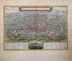
Fine example of Jansson's rare modern view of Rome, from his Theatrum Celebriorum Urbium Italiae, Aliarumque In Insulis Maris Mediterranei.
Striking bird's-eye plan of Rome with decorative title cartouche, showing the city as it was c. 1550. Included are various surviving features of ancient Rome: the surrounding walls, the Pantheon, the Coliseum, the Arch of Constantine, and the Forum Romanum. In the left corner in the foreground can be seen the Papal Palace and the Obelisk from the circus of Caligula and Nero.
The print, although engraved and published in Amsterdam in 1657, reproduces Rome around 1550, being a copy of Braun Hogenberg's plan, from which it differs only by the figures in the foreground [...] At the bottom, within two cartouches, a legend of 101 numbers" (cf. Marigliani, Le Piante di Roma, p. 153).
The original model, however, is to be found in Giovanni Francesco Camocio's plan from 1569 (or Leon Pitor's earlier one from 1568, as Scaccia Scarafoni claims) in which the city is portrayed from a bird's eye view from the Janiculum.
Jan Janssonius (also known as Johann or Jan Jansson or Janszoon) (1588-1664) was a renowned geographer and publisher of the seventeenth century, when the Dutch dominated map publishing in Europe. Born in Arnhem, Jan was first exposed to the trade via his father, who was also a bookseller and publisher. In 1612, Jan married the daughter of Jodocus Hondius, who was also a prominent mapmaker and seller. Jonssonius’ first maps date from 1616. In the 1630s, Janssonius worked with his brother-in-law, Henricus Hondius. Their most successful venture was to reissue the Mercator-Hondius atlas. Jodocus Hondius had acquired the plates to the Mercator atlas, first published in 1595, and added 36 additional maps. After Hondius died in 1612, Henricus took over publication; Janssonius joined the venture in 1633. Eventually, the atlas was renamed the Atlas Novus and then the Atlas Major, by which time it had expanded to eleven volumes. Janssonius is also well known for his volume of English county maps, published in 1646.
Etching, with fine later hand colour, some foxing on the margins, otherwise good condition.
Bibliografia
Marigliani n. 53; Scaccia Scarafoni n. 165; Van der Krogt 4, 42:15.
Johannes JANSSONIUS (1588-1664)
|
Johannes Janssonius, more commonly known to us as Jan Jansson, was born in Arnhem where his father was a bookseller and publisher (Jan Janszoon the Elder). In 1612 he married the daughter of the cartographer and publisher Jodocus Hondius, and then set up in business in Amsterdam as a book publisher. In 1616 he published his first maps of France and Italy and from then onwards he produced a very large number of maps, perhaps not quite rivalling those of the Blaeu family but running a very close second in quantity and quality. From about 1630 to 1638 he was in partnership with his brother-in-law, Henricus Hondius, issuing further editions of the Mercator/Hondius atlases to which his name was added. On the death of Henricus he took over the business, expanding the atlas still further, until eventually he published an 11-volume Atlas Major on a scale similar to Blaeu's Atlas Major.
The first full edition of Jansson's English County Maps was published in 1646 but some years earlier he issued a number of British maps in the Mercator/Hondius/Jansson series of atlases (1636-44); the maps were printed from newly engraved plates and are different from the later 1646 issue and are now rarely seen (see Appendix B for further details).
In general appearance Jansson's maps are very similar to those of Blaeu and, in fact, were often copied from them, but they tend to be more flamboyant and, some think, more decorative.
After Jansson's death his heirs published a number of maps in an Atlas Contractus in 1666 and later still many of the plates of his British maps were acquired by Pieter Schenk and Gerard Valck, who published them again in 1683 as separate maps.
|