
| Reference: | S35560 |
| Author | Pieter VANDER AA |
| Year: | 1725 |
| Zone: | Malta |
| Printed: | Leyden |
| Measures: | 365 x 278 mm |
| Reference: | S35560 |
| Author | Pieter VANDER AA |
| Year: | 1725 |
| Zone: | Malta |
| Printed: | Leyden |
| Measures: | 365 x 278 mm |
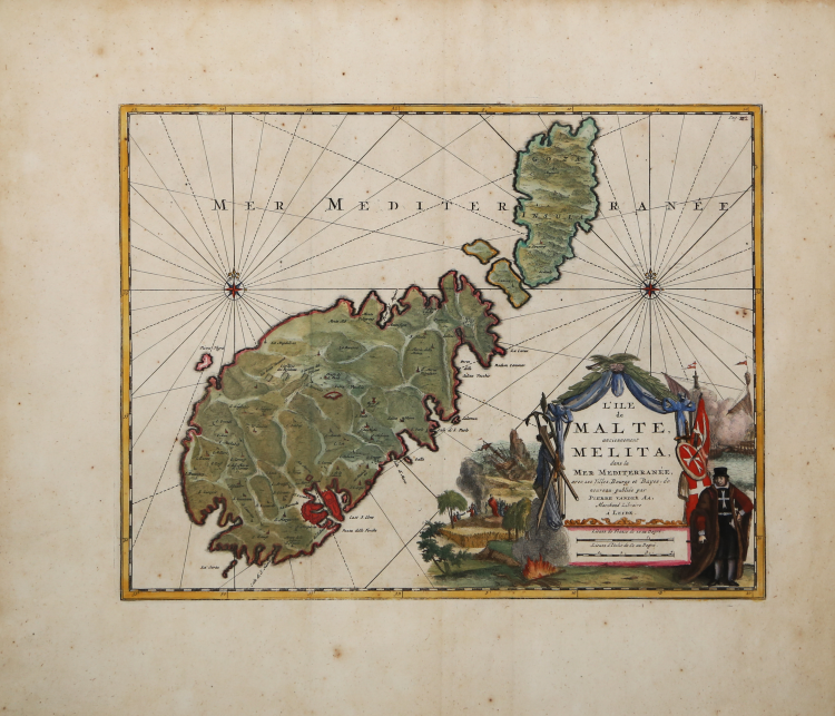
Map of the Mediterranean islands of Malta and Gozo by Pieter van der Aa taken from the Thesaurus antiquitatum et historiarum siciliae quo continentur rarissimi & optimi scriptores qui nobilissimarum insularum siciliae sardiniae, corsica . cura et studio Joannis Georgii Graevii.volumen decimum quintum... by Johannes Georgius Graevius, Lugduni Batauorum : excudit Petrus Vander Aa, 1723-1725.
The mapi s included in the last book, printed in 1725.
It includes two compass roses, with rhumb lines emanating from each one, along with details of the towns and harbours of the islands. The map includes a decorative title cartouche that portrays on its right side two battling sailing ships and a Maltese knight with his sword, shield and banner; and on the left a shipwreck together with snake emerging from a fire, which is a reference to the biblical story of St Paul’s visit to the island. Blank verso.
A finely coloured example of this uncommon map with wide margins in excellent condition.
Bibliografia
D. Cremonini, L' Italia nelle vedute e carte geografiche dal 1493 al 1894, pp. 97-100, n. 61.29.
Pieter VANDER AA (1659 - 1733)
|
Records show that van der Aa, born in Leyden in 1659, made an early start in life by being apprenticed to a bookseller at the age of nine and starting on his own in business as a book publisher by the time he was twenty-three.
During the following fifty years he published an enormous amount of material, including atlases and illustrated works in every shape and size, two of them consisting of no less than 27 and 28 volumes containing over 3,000 maps and plates.
Most of his maps were not of the first quality and were certainly not original, but they are often very decorative and are collected on that account.
|