
| Reference: | S29755 |
| Author | Antonio LAFRERI |
| Year: | 1565 |
| Zone: | Malta |
| Printed: | Rome |
| Measures: | 450 x 377 mm |
| Reference: | S29755 |
| Author | Antonio LAFRERI |
| Year: | 1565 |
| Zone: | Malta |
| Printed: | Rome |
| Measures: | 450 x 377 mm |
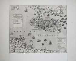
At the upper left cartouche: Nuovo disegno dell’Isola di Malta et suoi forti, Con li Isola di Comino, Gozo, et altre Isole vicine & Mostra di parte della Sicilia, Barbaria, e, Sardegna, & l’Annotazione della distansa di detti luoghi da Malta, per numero de Miglia, Non havendo potuto con Commodita ponere misura de Composso, perche l’Isola sarebbe venuta tanto piccola, che non si potrebbe discorrere sopra di essa cosa Alcuna: Dal Gozo Miglia 4. Da Sicilia cioe da Capo passaro M. 60. Da Tripoli di Barbaria M. 255. Dall’Isola de Gerbi M. 270. Da Tunesi Cio dall’Goletta M. 320. Da Sardegna M. 440. Dalla Morea di dove il Turco viene partendose da Costantinopoli verso Capo passero a Malta M. 550. Segue l’imprint editoriale: Ant. Lafrerj Romae Anno: 1565. Nel riquadro di destra: Luoghi Notabili dell’Isola di Malta Segnati p[er] Alfabeto, A Castel S. Angelo alto dal piano del acqua Canne 19. B Borgo la fronte alto C. 12. C S. Michele alto dal piano C. 10. D S. Elmo, alto dal piano C. 18. E Monte S.Salvatore alto C. 10. F Monte delle forche alto C. 15 1/2. G Colle di S. Margherita alto C. 15 1/2. H Terreni lavorati cinti de muri secchi. I Forte cominciato dali Turchi. L Giardino dell’Ill.mo et Re.mo S.or Gran Maestro. M Casale. N Porto Musetto. O Porto Marzo Sirocco. P Marza Scala. Q Forte della Marza. R Campo del Turco. S Vallone giardinato. T Luogo dove sono smontati li Christiani.
Map of the Maltese archipelago with the northern coasts of Africa, part of Sicily and Sardinia. The island of Malta is depicted out of scale, much larger than the rest of the other areas included, probably represented only to frame the geographical position of the island.
The work is dated by Albert Ganado (cf. A study in depth of 143 Maps representing the Great Siege of Malta of 1565) between the end of September and October 1565; the island is garrisoned by numerous boats, all with the symbol of the Christian cross, demonstrating the end of the Turkish siege. The geographical shape of the island follows a model from September 1565, an anonymous map published in Rome by the Palombi typography, printed in Rome (Ganado, n. 23).
The shape differs from previous models and follows neither the circular nor the fish-shaped morphology. The map is out of scale, with the Maltese archipelago much larger in proportion than Sicily, represented only for about half of its surface, and the northern coasts of Africa. Lafreri himself provides the explanation for this choice in the legend that accompanies the title: Non havendo potuto con Commodita ponere misura de Composso, perche l’Isola sarebbe venuta tanto piccola, che non si potrebbe discorrere sopra di essa cosa Alcuna [Not having been able to measure with the compass, because the Island would have been so small that it would not be possible to discuss anything about it]. The purpose of this map was probably to provide an overall view of the siege, placing the island geographically in a larger context and showing, for example, the route taken by the Gran Soccorso fleet.
The history of the island of Malta, the construction of the walled city, the war against the Turks and the famous siege of the island, is a matter of great interest in European Renaissance culture, so as to produce a relatively large literature and above all a remarkable iconographic production of sequence of events. The year 1565 is a landmark in the history of the Maltese Islands. It was also a turning-point in the struggle of Christendom against the forces of the Ottoman Empire, on which the battle of Lepanto (1571) put the final seal. Despite these two disasters, the Turks continued to ravage the coasts of the western Mediterranean during the rest of the century, after having recovered Cyprus from the Venetians and Tunis from the Spaniards; but the decline of their empire was in sight. The siege of Malta, which lasted from May till September 1565, was watched with trepidation not only in Naples, Rome and Venice, but even in Vienna, London and Madrid, in Paris, Antwerp and Brussels. News of the slow progress of the besiegers and of the desperate defence of the island reached Sicily through letters written by Grand Master La Valette, battle-sketches despatched by the Knights of the Order of St. John and “Relationi” written by soldiers or seamen. Thence it spread fanlike to all the centers of Christendom stretching from the Iberian Peninsula in the west to Hungary in the east. Picture-maps of the siege were produced in France, Germany, Spain and Italy to illustrate for the layman the stand being put up by Catholic Malta against the armed might of the Crescent, the main centers of production being Rome and Venice, which even turned out several editions of various broadsheets to bring up to date the latest developments in the bitter and uneven struggle. Albert Ganado, the major expert of Maltese cartography, lists over 60 maps on the island, in their various states, concentrated in a very short space of just 10 years.
Etching and engraving, 1565, signed and dated on the plate in the cartouche. Magnificent work, printed on contemporary laid paper with “lily in the circle” (Woodward 97), trimmed to the copperplate and with contemporary margins added, in perfect condition.
A very rare map, listed in Bifolco/Ronca in 20 institutional copies.
Bibliografia
Bifolco-Ronca, Cartografia e Topografia Italiana del XVI secolo, p. 1734, tav. 876; Alberti (2009): p. 106, n. 20; Almagià (1929): p. 32-II; Ganado-Vadalà (1995): pp. 257-261, n. 56, tav. 56; Rubach (2016): n. 239; Tooley (1939): n. 377.
Antonio LAFRERI (Orgelet 1512 - Roma 1577)
|
An engraver, publisher and dealer in prints and books. He moved in Rome about 1544, and began a series of joint ventures with the older Roman publisher Antonio Salamanca that continued until the latter's death in 1562. Lafrery in best known for prints showing the architecture and sculpture of ancient Rome. He commissioned a title page Speculum Romanae Magnificentiae, engraved by E. Duperac in 1573, to enable the buyer to compile his own collection from Lafrery's stock. Similarly realized collections of maps, different in the number and type of maps included with the title Geografia/Tavole moderne di geografia/de la maggior parte del mondo/di diversi autori/raccolte et messe secondo l’ordine/di Tolomeo/con i disegni di molte città et/fortezze di diverse provintie/stampate in rame con studio et diligenza/in Roma, known as Atlanti Lafrery. Besides the Speculum, Lafrery published two title pages for collections of religious subjects.
|