
| Reference: | S49654.2 |
| Author | William Henry SMYTH |
| Year: | 1822 |
| Zone: | Tyrrhenian Sea |
| Printed: | London |
| Measures: | 645 x 480 mm |
| Reference: | S49654.2 |
| Author | William Henry SMYTH |
| Year: | 1822 |
| Zone: | Tyrrhenian Sea |
| Printed: | London |
| Measures: | 645 x 480 mm |
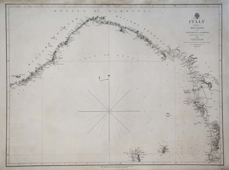
Nautical chart of the west coast of Italy, in the section extended from Ventimiglia to Piombino and including the Ligurian and Tuscan coasts. Drawn by William Henry Smyth, it is published by the Hydrographical Office, the military mapping institute of the British Navy.
The charts drawn by Smyth for the Hydrographical Office represent the earliest and most reliable “modern” nautical charts, accurately fixing the coordinates of all major headlands, harbors, and coastal places.
William Henry Smyth (Westminster 1788- St. John Lodge 1865), called “The Mediterranean” because of his long and important hydrographic work in that sea, was one of the principal scientists active in the English Hydrographical Office. Gifted with special sensitivity and both scientific and humanistic culture, he was also the author of scientific publications on the places he visited. In 1854 he published what became his most famous work The Mediterranean: a Memoir Physical Historical and Nautical. The figure of Englishman William Henry Smyth is quite complex and his activity as a cartographer one of several to which ours was devoted. Smyth had a specific and remarkable expertise especially with regard to marine hydrography, surveying and cartographic rendering, and archaeology, the latter understood, however, almost as a hobby, although grounded in solid historical-classical knowledge. Moreover, as a career officer in the world's most important navy (he attained the rank of rear admiral), he had undoubted expertise in the maritime field. Smyth was soon known to his contemporaries and appreciated as one of the best cartographers of his time; this is attested not so much by the official honors he received at home or leadership positions in famous cultural societies, but by his collaboration in official cartographic surveying activities concerted by governments of several countries, especially the anti-Napoleonic allies.
Etching, printed on contemporary paper, minimal restorations in upper margin, otherwise in very good condition. Very rare map.
Bibliografia
E. Manzi, William Henry Smyth, L'atlante coro-idrografico siciliano e i rapporti con la cartografia ufficiale delle Due Sicilie, in “Bollettino Della Societa' Geografica Italiana Roma” - SeT. X, VOI. XI, 1982, pp. 721-758.
William Henry SMYTH (Westminster 1788- St. John Lodge 1865)
|
William Henry Smyth, called “The Mediterranean” because of his long and important hydrographic work in that sea, was one of the principal scientists active in the English Hydrographical Office. Gifted with special sensitivity and both scientific and humanistic culture, he was also the author of scientific publications on the places he visited. In 1854 he published what became his most famous work The Mediterranean: a Memoir Physical Historical and Nautical. The figure of Englishman William Henry Smyth is quite complex and his activity as a cartographer one of several to which ours was devoted. Smyth had a specific and remarkable expertise especially with regard to marine hydrography, surveying and cartographic rendering, and archaeology, the latter understood, however, almost as a hobby, although grounded in solid historical-classical knowledge. Moreover, as a career officer in the world's most important navy (he attained the rank of rear admiral), he had undoubted expertise in the maritime field. Smyth was soon known to his contemporaries and appreciated as one of the best cartographers of his time; this is attested not so much by the official honors he received at home or leadership positions in famous cultural societies, but by his collaboration in official cartographic surveying activities concerted by governments of several countries, especially the anti-Napoleonic allies.
|