| Reference: | S41702 |
| Author | Jodocus HONDIUS Jr. |
| Year: | 1617 ca. |
| Zone: | Italy |
| Measures: | 495 x 370 mm |
| Reference: | S41702 |
| Author | Jodocus HONDIUS Jr. |
| Year: | 1617 ca. |
| Zone: | Italy |
| Measures: | 495 x 370 mm |
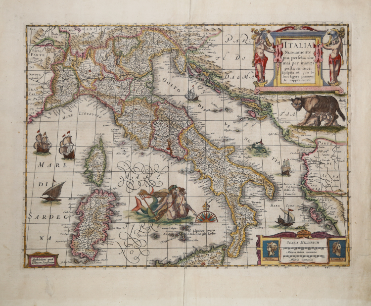
Beautiful example with antique coloring of the map of Italy by Jodocus Hondius II, one of the most decorative Italian maps of the early 17th century. The map is richly embellished with cartouches, sailing ships, sea monsters, and a Neptune with his companion. It includes portraits of Romulus and Remus in the lower right corner. Example of the fourth state with Janssonius’ imprint.
The map is first published in 1617; it is a loose map that is surrounded by views of cities and customs. The plate is later cut and the ornamental border disappears. The work is included in the Atlantis Maioris Appendix of Hendrick Hondius of 1631 and in some copies of the Theatrum Italiae of 1635. The fourth state of the plate is edited by Johannes Janssonius between 1644 and 1666.
“The title appears in a rectangular cartouche, flanked by standing figures, at the upper right. Below this cartouche is a drawing of a she-wolf nursing Romulus and Remus. The imprint is in a simple cartouche at the lower left. At the lower right is a cartouche with two bar scales, decorated by portraits of Romulus and Remus. […] The geographical content of Hondius's map, however, shows considerable progress when compared with the 1606 map by Willem Jansz Blaeu. Hondius based his knowledge on the work of the Italian cartographer Gioavanni Antonio Magini (1555-1617), who compiled a national atlas of Italy. As early as 1608 Magini published a wall map of Italy that was influential for many years. The map was not only imitated in Italy, but was also copied abroad several times, particu- larly in Amsterdam. Willem Jansz Blaeu initiated the series of imitations in the years 1614-17, followed by Hessel Gerritsz in 1617. A Hondius edition of Magini's wall map with the date 1617 is also known. Jodocus Hondius's map was very likely made by reducing this wall map to folio size, and thereby he inaugurated a new category of maps of Italy”. (cf. G. Schilder, Monumenta Cartographica Neerlandica, vol. V, pp. 376-78).
Literature
G. Schilder, Monumenta Cartographica Neerlandica, vol. V, pp. 376-78, Map 92, IV/IV; Koeman/Van der Krogt (1997) Map 7000:1C.3.
Jodocus HONDIUS Jr. (Amsterdam 1594 -1629)
|
Jodocus Hondius Jr. was born in 1593, and his earliest signed publication was a map of Scandinavia, issued in 1613. Son of Jodocus Hondius (1563-1612) - engraver, cartographer, printer and publisher – founder of the Hondius typography, that was one of the most important of the time, even thanks to the collection of Mercator’s plates and the pubblication of many charts and atlases. In 1604, Hondius bought the copperplates of Mercator’s Atlas at the auction of Gerard Jr.’s effects. He added another forty maps, including new maps of the Continents and important regional maps of the Americas, before publishing a new edition of the Atlas, in 1606, in competition with Ortelius’ Theatrum. As many of the maps were more up-to-date, the Mercator-Hondius Atlas effectively superseded Ortelius’ Theatrum. On his death in 1612 his widow, Coletta van den Keere continued the business with his two childs; Jodocus Jr. and Hendrick (1597-1651) took over. In June 1621, Jodocus Jr. married Anne Staffmaecker, and moved into a shop on the Dam, where he established his own publishing business. From the period 1621 onwards, Jodocus Jr. published a small number of maps, including several "figured border" maps, including maps of the four continents, the British Isles and Brabant. In 1618 Jodocus Jr. published the important map "Nova Virginiae Tabula", engraved by Dirk Grijp, being the first and most important derivative of John Smith's map of Virginia originally published in 1612. (Burden, America, 193). Other engravers who worked for Hondius are Abraham Goos, Salomon Rogiers, Evert Sijmonsz van Hamersveldt. Very little is known about the cooperation between the Hondius' brothers and their brother-in-law. Aside from the partnership in the continuation of Jodocus Sr's workshop (1612), it seems all three successively started their own businnes. However, from the map of Orange of 1627, it appears that a cooperation certainly extended as far as that year, as the map has a dedication by Jud. et Henr. Hondius to Frederick Henry. According to Peter van the Krogt (cf. Atlantes Neerlandici) Jodocus Hondius Jr. and his younger brother Henricus Hondius where competitors.
|