| Reference: | S41742 |
| Author | Melchior TAVERNIER |
| Year: | 1643 |
| Zone: | Italy |
| Measures: | 552 x 410 mm |
| Reference: | S41742 |
| Author | Melchior TAVERNIER |
| Year: | 1643 |
| Zone: | Italy |
| Measures: | 552 x 410 mm |
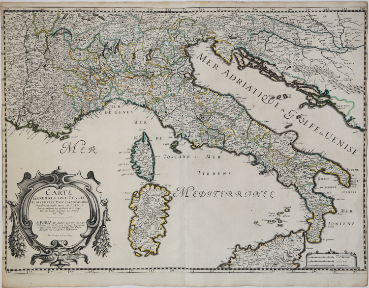
A rare map by Melchior Tavernier, based on Giovanni Antonio Magini wall map of Italy (1608). The map shows Italy and the surrounding area in detail, with all major rivers, towns, cities, and borders labeled. Italy is divided according to its many city-states, including the Kingdom of Naples, the Papal States, Florence, Genoa, Venice, and more. Parts of France, Switzerland, Austria, Slovenia, and Croatia are visible and detailed.
Example of the second state showing the date 1643 and the imprint by Pierre Mariette. The map was first published by Tavernier himself in 1640.
A decorative cartouche is included, and a shell contains a scale bar in Italian and French miles. The cartouche includes a short note about Tavernier's publishing business and his allegiance to the King of France.
Bibliografia
R. Borri, Italia nelle antiche carte dal Medioevo all'Unità nazionale, p. 136, scheda 127.
Melchior TAVERNIER (1564 ca. - 1644)
|
He was a member of a large family involved in the publishing trade in Paris in the early years of the seventeenth century .He is probably best known for his publication of a map of the Post Roads of France which was copied many times until the end of the century.He also issued an atlas under the same title as J. Le Clerc’s Theatre Geographique,using many of Le Clerc’s maps,but incorporating others from the maps noted below ,he pubblished works for other cartographers,including N.Sanson ,N.Tassin,and P.Bertius.He is not to be confused with his nephew of the same name (1594-1665),who also engraved maps for Nicolas Sanson.
1632 Carte Geographique des Postes qui traversent la France
1658 re-issued by N.Sanson
1634 Theatre Geographique du Royaume de France
1640-42 Description de la Carte Generale de tout le Monde
|