| Reference: | MS8164 |
| Author | Petrus PLANCIUS |
| Year: | 1605 |
| Zone: | Italy |
| Measures: | 330 x 240 mm |
| Reference: | MS8164 |
| Author | Petrus PLANCIUS |
| Year: | 1605 |
| Zone: | Italy |
| Measures: | 330 x 240 mm |
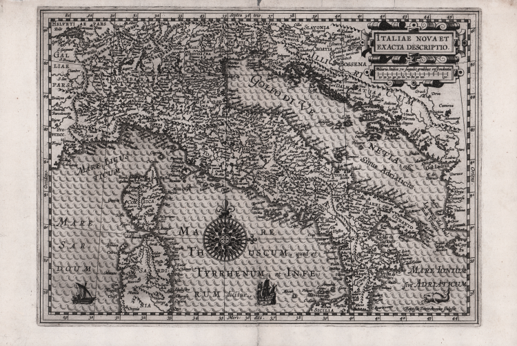
A rare map taken from Cosmographia Generalis by Paulus Merula.
The map, though clearly inspired by Mercator, represents a reduction of one made by Petrus Plancius in 1592.
A nice compass is placed at the center of the Tyrrhenian Sea. The plate is signed at lower right Baptiste Doetecumus sculpsit.
The qualityof Baptiste van Doetecum's engraving style is very evident in this map. Baptiste was the son of Joannes, who together with his brother Lucas, came from a family of engravers originally from Deventer, active in Antwerp, Haarlem and Amsterdam in the second half of the sixteenth century. In addition to the Spieghel maps, the Doetecums are authors of the most beautiful maps published by Hieronymus Cock, Gerard de Jode and Abraham Ortelius.
Copper engraving, in excellent condition.
Bibliografia
R. Borri, Italia nelle antiche carte dal Medioevo all'Unità nazionale (2011), scheda 86; The New Hollstein (Doetecum) n. 999; Gunter Schilder, Monumenta Cartographica Neerlandica, I, p. 30, 20.
|
Plancius was a theologian and minister of the Dutch Reformed Church who fled with many of his compatriots from religious persecution in Flanders to settle in Amsterdam in 1585. There he became interested in navigation and cartography and, being fortunate enough to have access to nautical charts recently brought from Portugal, he was soon recognized as an expert on the shipping routes to India. He was interested, too, in the idea of a North East passage until the failure of Willem Barentsz's third voyage in 1597 seemed to preclude the possibility of such a route. In 1602 he was appointed cartographer to the new Dutch East India Company.
Although Plancius produced no atlases his individual maps and charts, over 100 in all, exercised much influence on the work of other cartographers at the turn of the century. His very large wall map of the world dated 1592 was of particular significance.
|
|
Plancius was a theologian and minister of the Dutch Reformed Church who fled with many of his compatriots from religious persecution in Flanders to settle in Amsterdam in 1585. There he became interested in navigation and cartography and, being fortunate enough to have access to nautical charts recently brought from Portugal, he was soon recognized as an expert on the shipping routes to India. He was interested, too, in the idea of a North East passage until the failure of Willem Barentsz's third voyage in 1597 seemed to preclude the possibility of such a route. In 1602 he was appointed cartographer to the new Dutch East India Company.
Although Plancius produced no atlases his individual maps and charts, over 100 in all, exercised much influence on the work of other cartographers at the turn of the century. His very large wall map of the world dated 1592 was of particular significance.
|