| Reference: | S35731 |
| Author | John SENEX |
| Year: | 1708 ca. |
| Zone: | Italy |
| Printed: | London |
| Measures: | 952 x 665 mm |
| Reference: | S35731 |
| Author | John SENEX |
| Year: | 1708 ca. |
| Zone: | Italy |
| Printed: | London |
| Measures: | 952 x 665 mm |
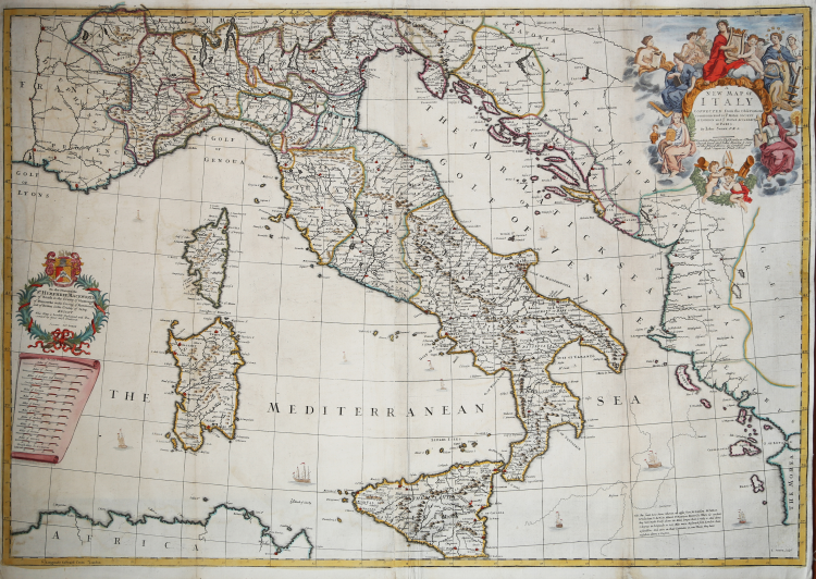
Interesting and rare large map of Italy. Top right side decorative cartouche with title. On left side other cartouche with dedications.
Second state of the map, relating to the period when John Senex worked with Charles Price (1705 - 10). The map bears the signatures of Price, Senex and John Maxwell in the cartouche.
In the lower right, next to the regions of Calabria and Sicily, a simple additional diagram specific to the two regions is shown. The shape of Calabria and northeastern Sicily according to how it had been depicted in the maps of Sanson, Visscher, De Wit, Allard, and Mortier is delineated. Next to it, we find a statement by the authors, "We differ from M.Sanson. H.Jaillot. N.Visscher. Allard. P.Mortier. Berry &c. where it is evident they have made Italy above 130 miles longer than it really is ...," which differentiates it from first-state ecxample.
John Senex (1678 - 1740) was one of the most important English map makers and publishers of the first half of the 18th century. He was first apprenticed to the prominent bookseller and publisher Robert Clavell, but his association with Jeremiah Seller and Charles Price led him to a career as a surveyor, cartographer, globe maker, and map publisher and seller. His contribution to the development of the British map trade was such that he was honored (1728) by election to membership in the Royal Society, sponsored by some of the greatest scientists of the period. His early career was relatively unhappy; the society with Jeremiah Seller and Charles Price lasted only 3 years and ended in bankruptcy, in 1706. From then on, until about 1710, he worked only with Price, from whom he learned and refined the art of engraving. The two devoted themselves to the design of an atlas of the world, competing with that of rival Herman Moll. When the partnership ended, Senex worked on his own cartographic collection, which was published as The English Atlas (1714); it was one of the most successful atlases of the century, being reprinted until 1760. Senex also worked as a semi-official engraver for the Royal Society, for its printer William Taylor, and for prominent figures within it, including Edmund Halley and William Whiston. He then published several important scientific maps, most notably Halley and Whiston's eclipse maps (1715 and 1724). These scientific contacts of his provided him with essential and innovative technical elements, useful for his wide range of terrestrial and celestial globes. With this solid foundation, Senex became the most prestigious map publisher of the time. Upon his death (1740) the printing press was directed by his widow Mary, who continued the business until 1755, when she retired; William Herbert and Robert Sayer acquired the rights to the cartographic works, while James Ferguson took over the part dealing with globes.
Charles Price (ca. 1679 - 1733) was an engraver, instrument maker and map maker; he had been first apprenticed to John Seller then a business partner of his son, Jeremiah. The two became associated with the London Merchants and Publishers Guild on the same day, September 1, 1703. After the dissolution of the partnership with Seller, Price worked with John Senex (1705 - 10) and George Wildey (1710 - 13). It is known that he was still active around 1730; in 1731 he was arrested for debt and died two years later. He is best known for publishing his Atlas Maritimus in 1732. This nautical collection contains maps dated between 1728 and 1731, but it is clear that the work remained unfinished, as evidenced by some maps that have blank spaces in the cartouches, probably reserved for dedications.
Copperplate engraving, beautiful original coloring with retouching, in very good condition.
|
Shirley, B.L. T.SEN-1a
|
John SENEX (Londra, 1678 – 1740)
|
John Senex (1678 - 1740) was one of the most important English map makers and publishers of the first half of the 18th century. He was first apprenticed to the prominent bookseller and publisher Robert Clavell, but his association with Jeremiah Seller and Charles Price led him to a career as a surveyor, cartographer, globe maker, and map publisher and seller. His contribution to the development of the British map trade was such that he was honored (1728) by election to membership in the Royal Society, sponsored by some of the greatest scientists of the period. His early career was relatively unhappy; the society with Jeremiah Seller and Charles Price lasted only 3 years and ended in bankruptcy, in 1706. From then on, until about 1710, he worked only with Price, from whom he learned and refined the art of engraving. The two devoted themselves to the design of an atlas of the world, competing with that of rival Herman Moll. When the partnership ended, Senex worked on his own cartographic collection, which was published as The English Atlas (1714); it was one of the most successful atlases of the century, being reprinted until 1760. Senex also worked as a semi-official engraver for the Royal Society, for its printer William Taylor, and for prominent figures within it, including Edmund Halley and William Whiston. He then published several important scientific maps, most notably Halley and Whiston's eclipse maps (1715 and 1724). These scientific contacts of his provided him with essential and innovative technical elements, useful for his wide range of terrestrial and celestial globes. With this solid foundation, Senex became the most prestigious map publisher of the time. Upon his death (1740) the printing press was directed by his widow Mary, who continued the business until 1755, when she retired; William Herbert and Robert Sayer acquired the rights to the cartographic works, while James Ferguson took over the part dealing with globes.
|
|
Shirley, B.L. T.SEN-1a
|
John SENEX (Londra, 1678 – 1740)
|
John Senex (1678 - 1740) was one of the most important English map makers and publishers of the first half of the 18th century. He was first apprenticed to the prominent bookseller and publisher Robert Clavell, but his association with Jeremiah Seller and Charles Price led him to a career as a surveyor, cartographer, globe maker, and map publisher and seller. His contribution to the development of the British map trade was such that he was honored (1728) by election to membership in the Royal Society, sponsored by some of the greatest scientists of the period. His early career was relatively unhappy; the society with Jeremiah Seller and Charles Price lasted only 3 years and ended in bankruptcy, in 1706. From then on, until about 1710, he worked only with Price, from whom he learned and refined the art of engraving. The two devoted themselves to the design of an atlas of the world, competing with that of rival Herman Moll. When the partnership ended, Senex worked on his own cartographic collection, which was published as The English Atlas (1714); it was one of the most successful atlases of the century, being reprinted until 1760. Senex also worked as a semi-official engraver for the Royal Society, for its printer William Taylor, and for prominent figures within it, including Edmund Halley and William Whiston. He then published several important scientific maps, most notably Halley and Whiston's eclipse maps (1715 and 1724). These scientific contacts of his provided him with essential and innovative technical elements, useful for his wide range of terrestrial and celestial globes. With this solid foundation, Senex became the most prestigious map publisher of the time. Upon his death (1740) the printing press was directed by his widow Mary, who continued the business until 1755, when she retired; William Herbert and Robert Sayer acquired the rights to the cartographic works, while James Ferguson took over the part dealing with globes.
|