| Reference: | S327120 |
| Author | Giuseppe LONGHI |
| Year: | 1675 |
| Zone: | Italy |
| Printed: | Bologna |
| Measures: | 2100 x 1150 mm |
| Reference: | S327120 |
| Author | Giuseppe LONGHI |
| Year: | 1675 |
| Zone: | Italy |
| Printed: | Bologna |
| Measures: | 2100 x 1150 mm |
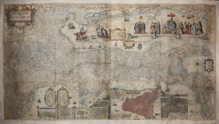
Wall map of Italy, engraved with etching and burin, printed on twelve sheets, with a total size of 1150x2100 mm.
In the cartouche at the top left with the space of the coat of arms empty the title ITALIA DI MATTEO GREUTER Revista et augmentata di molti luoghi principali MDCLXXV. Pietro Todeschi fece in Bologna. Gioseffo Longhi forma. Nel lato destro: in una lapide Questo Geografico Disegno è Voltato à traverso per la Comodità del Lettore e del Volume essendo non dimeno osservata la linea Meridionale et altezza Polare, con li suoi gradi et Minuti à Canto, et la longhezza secondo l’Eclittica da, piede, come l’intellige[n]te Lettore Conoscerà. In the small cartouche the imprint in Bologna appresso Gioseffo Longhi 1676. Followed by the Scala di Miglia Duodice.
At the top right the personification of Italy, a seated woman, with the side two characters representing the rivers Po and Tiber, and ten women in local costumes, from left Genovese, Lombard, Milanese, Venetian, Florentine, Roman, Nottonese, Matriciana, Napolitana, Sicilian. In the Adriatic Sea the effigy of Venice with the Lion of San Marco, the god Neptune, in a frame depicted Europe, the coats of arms of the Papal States and the Kingdom of Naples (Hapsburgs of Spain), and in a scroll LE XII PROVINCE DEL REGNO. 1. Terra di Lavoro, 2. Principato citra, 3. Principato ultra, 4. Basilicata, 5. Calabria citra, 6. Calabria ultra, 7. Terra d’Otranto, 8. Terra di Bari, 9. Abruzzo citra, 10, Abruzzo ultra, 11. Co[n]tado di Molise, 12. Capitanata.
Below the plants or bird's eye view of some cities Milan, Venice, Rome, Florence, Naples, Messina, are then depicted in two ovals Corsica and Sardinia, in a square Sicily and the plans of Palermo, ancient Syracuse and Catania. Orientation with two wind roses, north-east at the top. Graduation in the margins, for latitude of 1' in 1' from 37° 34' to 42° 20' right side, from 43° 23' to 48° 7' left side, for longitude of 5' in 5' from 28° 25' to 39° 34' bottom side, from 32° 29' to 44° 5' top side.
Exemple in the first state of two. Derivation of the wall map of the peninsula by Matteo Greuter (or even the copy of Stefano Scolari of 1657) published by Giuseppe Longhi in Bologna in 1676. It is a replica, made by carving new plates, and not a reprint of the map of Scolari as claimed by all bibliographies. Two editions of this new map are known; the first of 1675 (Florence, IGM, inventory n. 3161) and a reprint of 1713, recently appeared on the antiquarian market and now in a private collection. The map is signed by Pietro Todeschi, probably as the engraver of the plates, and dated 1675.
There are no known issue with an earlier date, but only proofs published by Giuseppe Longhi in 1676. For an accurate description regarding the historical-critical aspect of the map, see Roberto Borri, L'Italia nelle antiche carte dal Medioevo all'unità nazionale (2010).
A fine impression on contemporary laid paper, applied on canvas, reconstructive restorations perfectly executed in some points of the map, contemporary coloring on part of the surface, overall in good condition.
Bibliografia
cfr. Aliprandi (2005): pp. 95-97; Almagià (1929): p. 64, 7.3; Borri (1999): p. 81; cfr. Borri (2010): pp. 123-129, fig. 145; cfr. Fiorini (1898): pp, 282 e 367; cfr. Lago (2002): pp. 742-743, fig. 701; Valerio (2011): pp. 64-66, n. 22 (4); cfr. Valerio-Spagnolo (2014): pp. 268-269, n. 107.
|
Gioseppe (Giuseppe) Longhi was an engraver in Bologna, who was active between 1670 and 1690. He is perhaps best known in cartographic circles as the publisher of a 12 sheet Nova Totius Terrarum Orbis Tabula (known in 3 examples), issued in about 1680, which is based upon Frederick De Wit's World Map of 1660 (Shirley 471. See also, Cartographic Treasures of the Newberry Library, October 10, 2001 - January 19, 2002 exhibition catalogue). Longhi also issued a copy of Matthaus Greutter's 12-sheet wall map of Italy in 1676 and is known to have engraved 4 sheet views of Vienna, Prague, Genoa, Venice, Naples and Bologna, based upon the work of earlier Dutch engravers. Longhi was likely associated with Pietro Todeschi, who was active in Bologna from 1670 to 1690.
|
|
Gioseppe (Giuseppe) Longhi was an engraver in Bologna, who was active between 1670 and 1690. He is perhaps best known in cartographic circles as the publisher of a 12 sheet Nova Totius Terrarum Orbis Tabula (known in 3 examples), issued in about 1680, which is based upon Frederick De Wit's World Map of 1660 (Shirley 471. See also, Cartographic Treasures of the Newberry Library, October 10, 2001 - January 19, 2002 exhibition catalogue). Longhi also issued a copy of Matthaus Greutter's 12-sheet wall map of Italy in 1676 and is known to have engraved 4 sheet views of Vienna, Prague, Genoa, Venice, Naples and Bologna, based upon the work of earlier Dutch engravers. Longhi was likely associated with Pietro Todeschi, who was active in Bologna from 1670 to 1690.
|