
| Reference: | S22015 |
| Author | Giovanni Antonio MAGINI |
| Year: | 1620 |
| Zone: | Italy |
| Printed: | Bologna |
| Measures: | 485 x 350 mm |
| Reference: | S22015 |
| Author | Giovanni Antonio MAGINI |
| Year: | 1620 |
| Zone: | Italy |
| Printed: | Bologna |
| Measures: | 485 x 350 mm |
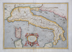
Ptolemiac map of Italy, taken from L'Italia di Giovanni Antoni Magini; printed in Bologna by Fabio Magini, between 1620 and 1640.
The map, the only Ptolemaic map in the Atlas, is derived from that of Gerard Mercator, published in Cologne in 1578.
Just as Mercator did before, this map is not a drawing of the Peninsula in the early seventeenth century, but a tribute that Magini offers to Ptolemy, the supreme Alexandrian geographer of the second century CE. The shape of the peninsula has that distortion characteristic of maps of Italy built according to Ptolemaic dictates and a toponymy that harks back to the Greco-Roman world.
Magini had already produced the best representation of the peninsula in 1608, with his large wall map that would prove to be the model for all seventeenth-century cartography.
The map inaugurates L'Italia di Giovanni Antoni Magini; consisting of a short descriptive text of only 24 maps, the work has 61 maps of the peninsula, and is the first example of an Italian atlas. The work is entirely by the hand of Magini, who began the making of the maps in about 1594, giving birth first in 1595 to the map of the territory of Bologna. All the maps therefore came to print before 1620, in their provisional drafts, later corrected and updated for the final edition. Magini used two of the most famous engravers of the time to make the plates: the Flamish Arnoldo Arnoldi and the English Benjamin Wright.
Etching, finely hand-colored, in perfect condition.
Bibliografia
R. Borri "L'Italia nelle antiche carte…" (2011), scheda 19.
Giovanni Antonio MAGINI (1555 - 1617)
|
Giovanni Antonio Magini was born in Padua in 1555, dedicating himself to the study of astronomy from an early age. In 1588 the Senate of Bologna appointed him Lecturer of Astronomy at the local University, choosing him instead of Galileo Galilei. His friendship with the Duke of Mantua, Vincenzo Gonzaga, helped Magini in his quest to obtain cartographical material for map-making from the various sovereigns ruling the different Italian states at that time. Because of Magini's early death in 1617, this effort was made famous by his son Fabio when he published the atlas "L'Italia" in Bologna in 1620. This is the first example of an Italian atlas and is made up of 24 pages of descriptive text and 61 maps of the Italian peninsula. Although this work was published posthumously, it can be entirely ascribed to Magini. He began drawing this maps around 1594, with the one depicting Bologna and its surrounding territories being the first. They were all printed before 1620 in draft editions which were then revised and updated for the final version. These draft proofs are extremely rare, although sometimes available for sale, and exhibit substantial differences in respect to the maps finally included in the atlas. Two of the most famous engravers of the time, Arnoldo Arnoldi and the englishman Benjamin Wright, were entrusted by Magini to engrave the plates. As we shall see in the presentation of the separate maps, they derive from different sources, both known and unknown, and therefore represent the result of an original work of critical analysis and compilation. This atlas had an important influence on the cartography of the italian peninsula for the following two centuries, beginning from Ortelius and going on to the principal dutch cartographers and editors.
|