
| Reference: | S48756 |
| Author | Johannes Baptiste VRIENTS |
| Year: | 1608 ca. |
| Zone: | Italy |
| Printed: | Antwerpen |
| Measures: | 152 x 90 mm |
| Reference: | S48756 |
| Author | Johannes Baptiste VRIENTS |
| Year: | 1608 ca. |
| Zone: | Italy |
| Printed: | Antwerpen |
| Measures: | 152 x 90 mm |
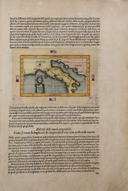
Small map of Italy inserted in a text sheet; it was engraved in 1608, by or on behalf of Jan Baptiste Vrients, for inclusion in Abraham Ortelius's Theatrum Orbis Terrarum, which Vrients continued to publish as executor of Ortelius's will. Therefore, it appeared only in the final four editions of Ortelius' atlas and is consequently one of the scarcest maps among those appearing in that work.
The map is included in the introductory section of Theatro Del Mondo Di Abrahamo Ortelius: Da lui poco inanzi la sua morte riveduto, dedicated to "Introduttione Mathematica nelle plate Geografiche del Teatro del mondo di Abrahamo Ortelius [...] composta per Michele Coigneto mathematico".
Among the editions of the Theatrum, this 1608 edition printed by Vrients is one of the most appreciated thanks to the work of translation from Latin into Italian by Filippo Pigafetta from Vicenza.
The portion of text surrounding the map of Italy describes how to derive longitude and latitude measurements from maps, and the engraving serves as an example. Italy is outlined schematically with only the coastal profile, based on Mercator, and some cities shown in castle form. Little hands placed at the four quadrants hold two straight wires that identify the location of Rome with its meridian and parallel. The back of the sheet illustrates how to use these numbers to calculate distances between cities, and in particular shows how, numbers in hand, walking 10 hours a day assuming you have “da pertutto transito commodo”, and you can make “il viaggio d'intorno alla terra in spacio de duoi anni manco 10 giorni”.
Johannes Baptiste Vrients (1552-1612) was a Flemish engraver, publisher and cartographer. Not much is known about his early life, but it is assumed that he grew up as an apprentice among the cartographers of Antwerp, where the guild appointed him master in 1575. In the 1590s he executed maps of the world for Plancius and Linschoten. In 1600 he became executor of Ortelius' will and acquired the Theatrum plates after the cartographer's death. Between 1606 and 1612 he published more editions of Ortelius' atlas. Vrients also acquired De Jode's Speculum plates around 1600, but he did not republish that work, although he kept De Jode's plates depicting the Electors of the Holy Roman Empire, reprinting them in his editions of the Ortelius atlas after 1603. Vrients' editions of the Theatrum were published not in Antwerp (the city had fallen during the Dutch war with Spain) but in Amsterdam.
Etching with magnificent contemporary coloring, in very good condition.
|
Borri "L'Italia nelle antiche carte…", scheda 100.
|
Johannes Baptiste VRIENTS (1552 - 1612)
|
Vrients was the map engraver and publisher in Antwerp who, after the death of Ortelius in 1598, acquired the publication rights of the Theatrum. Between 1601 and 1612 he issued a number of editions which included some of his own maps and he was responsible for printing the maps for the English edition in 1606. He also published a number of important individual maps and a small atlas of the Netherlands.
|
|
Borri "L'Italia nelle antiche carte…", scheda 100.
|
Johannes Baptiste VRIENTS (1552 - 1612)
|
Vrients was the map engraver and publisher in Antwerp who, after the death of Ortelius in 1598, acquired the publication rights of the Theatrum. Between 1601 and 1612 he issued a number of editions which included some of his own maps and he was responsible for printing the maps for the English edition in 1606. He also published a number of important individual maps and a small atlas of the Netherlands.
|