- New

| Reference: | S50401 |
| Author | Martineau du Plessis |
| Year: | 1700 |
| Zone: | Italy |
| Printed: | Paris |
| Measures: | 215 x 160 mm |
| Reference: | S50401 |
| Author | Martineau du Plessis |
| Year: | 1700 |
| Zone: | Italy |
| Printed: | Paris |
| Measures: | 215 x 160 mm |
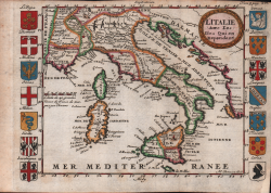
A rare map of Italy published in 1700, in Martineau du Plessis's treatise, Nouvelle Géographie, ou Description Exacte de l'Univers.
The map depicts the political division of the Italian peninsula and its main islands in 1700 and is surrounded by sixteen coats of arms representing various Italian regions: Piedmont, Modena, Genoa, Milan, Sicily, Sardinia, Tuscany, Savoy, Dauphiné, Provence, Dalmatia, the Papal States, and the Kingdom of Naples.
Martineau du Plessis (active around 1700) was a French geographer and teacher originally from Fontenay, probably Fontenay-le-Comte. He is best known for his multi-volume geographical work, Nouvelle Géographie, published in 1700.
Etching, finely hand-colored, in excellent condition.
Martineau du Plessis
Martineau du Plessis