

| Reference: | S51148 |
| Author | Rigobert BONNE |
| Year: | 1787 ca. |
| Zone: | Italy |
| Printed: | Paris |
| Measures: | 225 x 335 mm |
| Reference: | S51148 |
| Author | Rigobert BONNE |
| Year: | 1787 ca. |
| Zone: | Italy |
| Printed: | Paris |
| Measures: | 225 x 335 mm |
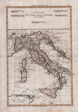
Carta dell’Italia tratta dal “Atlas encyclopédique, contenant la géographie ancienne et quelques cartes sur la géographie du Moyen Âge, la géographie moderne, et les cartes relatives à la géographie physique” di Rigobert Bonne e Nicolas Desmarest, edito a Parigi nel 1787-88, "Par M. Bonne, Ingénieur-Hydrographe de la Marine, et par M. Desmarest, de L'Académie Royale des Sciences".
Rigobert Bonne (1727-1795) è stato uno dei più importanti cartografi della fine del XVIII secolo. Nel 1773 successe a Jacques Bellin come cartografo reale di Francia nell'ufficio dell'idrografo del Dipartimento della Marina. Lavorando in veste ufficiale, Bonne compilò alcune delle mappe più dettagliate e accurate dell'epoca. Il lavoro di Bonne rappresenta un passo importante nell'evoluzione dell'ideologia cartografica, che si allontana dal lavoro decorativo del XVII e dell'inizio del XVIII secolo per passare a un'estetica più orientata al dettaglio e alla pratica. Per quanto riguarda la resa del terreno, le carte di Bonne presentano molte somiglianze stilistiche con quelle del suo predecessore, Bellin. Tuttavia, le mappe di Bonne abbandonano in genere le caratteristiche decorative comuni del XVIII secolo, come la colorazione a mano, gli elaborati cartigli decorativi e le rose delle bussole. Pur concentrandosi principalmente sulle regioni costiere, il lavoro di Bonne è molto apprezzato per i suoi dettagli, l'importanza storica e l'estetica generale.
L'Atlas Encyclopédique, opera che il Bonne portò a termine con l'ausilio di Nicholas Desmarest, costituisce il suo lavoro di maggior fama.
Acquaforte, finemente colorata a mano, ottimo stato di conservazione.
Rigobert BONNE (1727 - 1795 ca.)
|
Rigobert Bonne was born in 1727 in Raucourt, in the Lorraine region of northeastern France. He was not only a cartographer but also a hydrographer who produced both land and nautical maps; he spent much of his career working in the French Hydrographic Office or Dépôt des cartes et plans de la Marine. As Royal Hydrographer, Bonne's main interest was the production of nautical maps, but he also gave to print a considerable number of other works, including maps by other cartographers who were his collaborators. He first came to prominence producing a series of plates for the Atlas Moderne ou Collection De Cartes Sur toutes les parties du Globe Terrestre par Plusieurs Auteurs, edited by Giovanni Antonio Rizzi Zannoni and first published in Paris by Jean Lattré in 1762, and subsequently reprinted-with the addition of numerous plates by other cartographers-until the end of the century. But he is probably best known for later publications, including the Atlas Encyclopedique-in collaboration with Nicholas Desmarest (1725-1805)-as well as for the maps he made for Guillaume Raynal's Atlas de Toutes Les Parties Connues du Globe Terrestre (1780). His maps were often commissioned more for educational and informational purposes than for practical use. In 1773, Bonne's talent was rewarded with the title of "Hydrographe du Roy," succeeding Jacques-Nicolas Bellin. From him took its name the pseudoconic projection, adopted, among other things, for the general map of France.
|