
| Reference: | S49970 |
| Author | John SENEX |
| Year: | 1712 |
| Zone: | Ireland |
| Printed: | London |
| Measures: | 680 x 970 mm |
| Reference: | S49970 |
| Author | John SENEX |
| Year: | 1712 |
| Zone: | Ireland |
| Printed: | London |
| Measures: | 680 x 970 mm |
Map shows South Africa until the equator with Madagascar, Mauritius and Réunion.
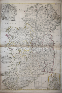
Large, decorative map of Ireland printed in London by John Senex in 1712. Title and editorial details are contained in the handsome decorative cartouche at upper left, while the map of the British Isles is located at lower right.
John Senex (1678-1740) was one of the foremost mapmakers in England in the early eighteenth century. He was also a surveyor, globemaker and geographer. As a young man, he was apprenticed to Robert Clavell, a bookseller. He worked with several mapmakers over the course of his career, including Jeremiah Seller and Charles Price. In 1728, Senex was elected as a Fellow of the Royal Society, a rarity for mapmakers. The Fellowship reflects his career-long association as engraver to the Society and publisher of maps by Edmund Halley, among other luminaries. He is best known for his English Atlas (1714), which remained in print until the 1760s. After his death in 1740, his widow, Mary, carried on the business until 1755. Thereafter, his stock was acquired by William Herbert and Robert Sayer (maps) and James Ferguson (globes).
Etching with contemporary outline colour, in good condition.
John SENEX (Londra, 1678 – 1740)
|
John Senex (1678 - 1740) was one of the most important English map makers and publishers of the first half of the 18th century. He was first apprenticed to the prominent bookseller and publisher Robert Clavell, but his association with Jeremiah Seller and Charles Price led him to a career as a surveyor, cartographer, globe maker, and map publisher and seller. His contribution to the development of the British map trade was such that he was honored (1728) by election to membership in the Royal Society, sponsored by some of the greatest scientists of the period. His early career was relatively unhappy; the society with Jeremiah Seller and Charles Price lasted only 3 years and ended in bankruptcy, in 1706. From then on, until about 1710, he worked only with Price, from whom he learned and refined the art of engraving. The two devoted themselves to the design of an atlas of the world, competing with that of rival Herman Moll. When the partnership ended, Senex worked on his own cartographic collection, which was published as The English Atlas (1714); it was one of the most successful atlases of the century, being reprinted until 1760. Senex also worked as a semi-official engraver for the Royal Society, for its printer William Taylor, and for prominent figures within it, including Edmund Halley and William Whiston. He then published several important scientific maps, most notably Halley and Whiston's eclipse maps (1715 and 1724). These scientific contacts of his provided him with essential and innovative technical elements, useful for his wide range of terrestrial and celestial globes. With this solid foundation, Senex became the most prestigious map publisher of the time. Upon his death (1740) the printing press was directed by his widow Mary, who continued the business until 1755, when she retired; William Herbert and Robert Sayer acquired the rights to the cartographic works, while James Ferguson took over the part dealing with globes.
|