| Reference: | s199 |
| Author | Vincenzo CORONELLI |
| Year: | 1688 ca. |
| Zone: | Ayuthaya |
| Printed: | Venice |
| Measures: | 430 x 270 mm |
| Reference: | s199 |
| Author | Vincenzo CORONELLI |
| Year: | 1688 ca. |
| Zone: | Ayuthaya |
| Printed: | Venice |
| Measures: | 430 x 270 mm |
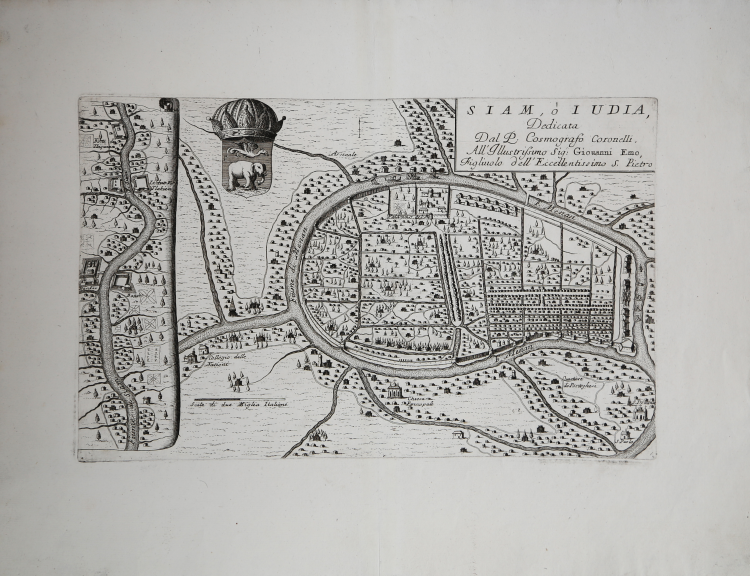
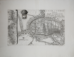
Scarce and historically important map of the Siamese capital of Ayutthaya, by Vincenzo Maria Coronelli, issued immediately prior to the Siamese Revolution of 1688, which henceforth restricted European activities in the kingdom.
This example of the map is taken from the very rare Coronelli's "Citta, Fortezze e, Isole, e Porti principlai dell'Europa in Pianta et in Elevatione, Descritte, e Publicate Ad uso dell'Accademia Cosmografica degli Argonauti dal Padre Maestro Coronelli Lettore, e Cosmografo della Serenissima Republica di Venezia" printed in Venice by Domenico Padovani in 1689.
The present work is the finest and most important printed map of Ayutthaya (transliterated on the map as 'Iudia'), which served as the capital the Kingdom of Siam (Thailand) during the ‘golden age’ of the Ayutthaya Period (1351-1767). Ayutthaya was located further up the Chao Praya River from modern Bangkok and is thought to have been the world’s largest city at time, with over 1 million residents. Foreign visitors were dazzled by the scope and wealth of the metropolis, which was favorably compared to Paris. Siam was then a major Asian power, and included not only present day Thailand, but also parts of modern Cambodia and Malaysia.
As shown, the city was located on an island, divided by canals. Large temples and palaces were built near the water, while substantial built up areas of houses with market places made up the majority of the city. Areas alloted to Europeans are noted, such as the appearence of several churches and the long-established 'Quatrtiere de Portughesi' (Portuguese Quarter). An inset on the left shows the progress of the ‘F[leuve] Siam’ (Chao Praya River) southwards towards ‘Bancoc’ (Bangkok), then a comparatively small fortified settlement. The composition is finished by the appearance of the attractive royal arms of Siam, which feature an elephant.
Siam was first visited by Europeans in 1511, when Duarte Fernandes led a Portuguese embassy to Ayutthaya. While Siam was never formally colonized or claimed by a European power, the French and Dutch had set up trading posts and Christian missions along the Chao Praya estuary.
The present plan was the result of France's first embassy to Siam 1685, which was led by the Chevalier de Chaumont in the company of six Jesuit fathers. Louis XIV had long maintained an especially friendly correspondence with King Narai of Siam (ruled 1656-1688), and was eager to shore up their relationship. During Chaumont’s visit, his Jesuit companions, who were well-versed in cartography, made manuscript plans of Ayutthaya which were soon dispatched to Paris.
However, shortly after Chaumont’s embassy, there was an intense popular uprising against the growing foreign presence in Siam and the king’s seeming obsession with everything European. King Narai even went as far as to make a Greek adventurer, Constantine Phaulkon, his de facto prime minister. This was all too much for Siamese officials and nationalists.
In what became know as the Siamese Revolution of 1688, forces loyal to the Mandarin Phetracha overthrew Narai’s government. Phetracha ascended to the throne and immediately expelled the French from Siam, while severely limiting the activities of the Dutch and other foreigners. This ensured that following the publication of the present map very little new European mapping was executed in Siam during the 18th-century.
Ayuttaya was sacked by the Burmese in 1767, which led to the fall of the Ayutthaya kingdom, after which point Bankok grew in importance. Today many fine ruins can still be visited in Ayutthaya.
The present map was issued by Vincenzo Maria Coronelli (1650-1715), a Venetian master who had been invited to Paris by Louis XIV to undertake cartographic projects, including the construction of the colossal ‘Marly Globes’. Coronelli was given access to the Jesuit manuscripts of Ayutthaya, which they fashioned into the present map. This map is one of several groundbreaking Coronelli maps of many parts of the World, done during a time when France assumed a leading role in the exploration of America and Asia.
The Coronelli plan of Ayutthaya is one of the most important early maps relating to Thailand and Asian urban history, and is a cornerstone of any serious collection.
Vincenzo CORONELLI (Venezia 1650 - 1718)
|
Cosmographer, geographer, biographer, encyclopedist, globe maker, inventor, expert of engeneering and hydraulics. Extraordinarily versatile mind and an extremely tireless man, he produced more than 140 pieces in different genres. At the age of 15, he entered the Franciscan Order, which he then guided as Gran Generale from 1699. He became famous as geographer and mathematician, awakening the interest in these subjects in Italy at the end of the XVII century. He travelled a lot, seeking for all that was new, and keeping a correspondance with the most important intellectuals of his time. In 1681 Louis XIV wanted him to go to France, to entrust him with the task of making two terraqueous globes (Marly Globes), with a diameter of 4 metres. Once he came back to Italy, in 1685, he became Cosmographer of the Venetian Republic, where he taught geography and founded the first geographic accademy, called The Argonauts Accademy. In his whole life he produced more that 500 maps; some of them can be found in his most famous works, such as the Venetian Atlas (1690), the Island Book of the Venetian Atlas (1696-97), the Book of Globes (1693). As far as his scientific method, he didn’t elaborate new cartographic systems, but followed the theories that were considered most popular and effective at his time, based on the Copernican system. The main characteristic of his charts is the high quantity of toponymic and historical information. In his most famous and dense work, the Venetian Atlas, we can find about 1100 plates, 200 of which are extremely technical and this is the reason why it is considered the first Italian atlas to describe and illustrate the whole world with charts and maps. It was published in 13 volumes, starting from 1690, and it took nearly ten years to finish it. It is divided in different parts, the most important are the Atlas itself, then the Island Book, the Corso Geografico and the Teatro delle città.
|