| Reference: | S34962 |
| Author | Henrick SCHERER |
| Year: | 1702 ca. |
| Zone: | The Holy Land |
| Printed: | Munich |
| Measures: | 351 x 232 mm |
| Reference: | S34962 |
| Author | Henrick SCHERER |
| Year: | 1702 ca. |
| Zone: | The Holy Land |
| Printed: | Munich |
| Measures: | 351 x 232 mm |
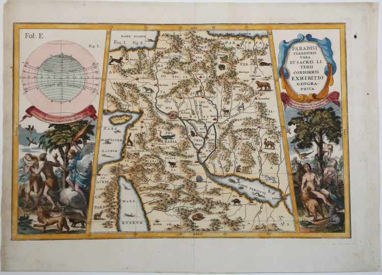
This is a very decorative and interesting map of the Middle East covering the biblical regions from the Black and Caspian Seas through most of the Arabian Peninsula. The map concentrates primarily on the geographical features with only a few important place names. Paradisus is located on the Euphrates River.
A variety of wild animals (including a unicorn) and sea monsters fill the map. At sides are scenes of Eve offering the apple to Adam and the expulsion from the garden.
Decorative map by Heinrich Scherer for his Atlas Novus exhibens orbem terraguem per naturae opera, historiae navae acveterus monumenta, artistique geographicae leges et praecepta...published in eight volumes from 1702-1710 in Munich. Scherer, a devout Jesuit, produced this geographical compendium to depict the Catholic hierarchy and the spread of Jesuit missions throughout the world.
The 180 maps included in this work were prepared between 1699 and 1700 and were engraved by Leonard Hecknaeur, Joseph Montelegre or Matthus Wolfgang with each volume introduced by fine allegorical frontispieces by the same engravers.
Copperplate, with fine later hand coplour, very good condition.
Henrick SCHERER (Dilingen 1628 - Monaco 1704)
|
Heinrich Scherer was a devout Jesuit, and professor of mathematics at Munich. His 'Atlas Novus' contained maps of all other parts which showed the spread of Catholicism and Jesuit missions.
|
Henrick SCHERER (Dilingen 1628 - Monaco 1704)
|
Heinrich Scherer was a devout Jesuit, and professor of mathematics at Munich. His 'Atlas Novus' contained maps of all other parts which showed the spread of Catholicism and Jesuit missions.
|