
| Reference: | S4773 |
| Author | Abraham ORTELIUS |
| Year: | 1597 ca. |
| Zone: | Indian Ocean |
| Printed: | Antwerpen |
| Measures: | 475 x 370 mm |
| Reference: | S4773 |
| Author | Abraham ORTELIUS |
| Year: | 1597 ca. |
| Zone: | Indian Ocean |
| Printed: | Antwerpen |
| Measures: | 475 x 370 mm |
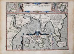
Striking historical map of the Indian Ocean and contiguous regions of the Middle East, India and Southeast Asia, published by Ortelius in his Parergon. The map includes insets of the North Pole and "Annonis Periplus" and "Ulyssis Errores" which is centered on Greese. The cartographic sources of this map are based on Homer's Odyssee, Isaac Tzetzes, Ovidius and Ausonius. King Hanno from Carthago is supposed to be the first to sail around the continent of Africa to reach the Arabian sea, and incidentally also the first to tame a lion. Ortelius states that the inset of Hyperborei (the Pole) 'for better beautifying or proportioning of this map', and to remind the reader that in spite of the best efforts of modern explorers, a passage to the Far East via the North Pole has not yet been found by the English or the Dutch.
A first state of two of the plate, with 2 lines of text in the main cartouche.
Title: ERYTHRAEI SIVE RVBRI MARIS PERIPLVS, | "olim ab Arriano descriptus, nunc vero ab Abrah. Ortelio ex eodem delineatus" (in second state:) OLIM AB ARRIANO DESCRIPTVS | NVNC VERO ABABRAH. ORTELIO EX EODEM DELINEATVS. [Erythræi or the Red Sea, earlier described by Arrianus, but now on this basis depicted by Abraham Ortelius]. Bottom right: “Cum Imp. Reg. et Can|cellariæ Brabantiæ privi|legio decennali 1597”. [With a privilege from his majesty the king and the Brabant council for ten years, 1597]. Centre: "Dioscoridis insula, | subiecta regi Eleazi | cui quoque tota regio | Thurifera". [The isle of Dioscorides, subject to king Eliazus, who also rules the entire region of Thurifera]. Following21 lines of text in Indochina peninsula:) "Arrianum huius Peripli auctorem alium eße ab eo qui Alexan:|dri Magni descripsit expeditionem, videtur Bap. Ramusio in | suo ad eundem Commentariolo Italica lingua edito: quia | utriusque nempe stylus dispar sit atque dissimilis. Idem hunc nostrû | Ptolemæi temporibus vixiße autumat : cui quod | quodammodo adsentiar, facit quod hic ipse in suo | Euxini periplo Traianum Imp. adloquitur. Atque | alium multò vetustiorem mihi veresimile, quod | ille inter eos quos citat scriptores, vix recen:|tiorum Herodoto aut Euripide nominet. | Vtut sit, diuersos facilè lector intelliget, | qui utriusque, huius nempe Nearchi | ab Indo flumine ad Tigridis ostij | nauigationem, cum illius contra | ab eodem ostio ad dictum | Indum, quem Sinthum nun:|cupat, legendo contulerit: | ne uno quidem loci | nomine inter hos | namque convenire | depræhendet". [Arrianus, the author of this Periplus [coastal sea journey] is someone who is different from the person who has written about the expedition of Alexander the Great, as it seems to Baptist Ramusio, in his comments on him published in the Italian language because their style of writing is different and dissimilar. He also thinks that he must have lived in the time of Ptolemæus. With which I somehow agree, for he seems to address himself in his Periplus on the Euxine Sea to Traianus the emperor. But the other [source] truly seems to be much older, because among others, he cites authors who are hardly more recent than Herodotus and Euripides. Whatever the case may be, the reader will easily gather from the various sources that one of these two from Nearchus at the river Indus navigated to the mouth of the river Tigris, and from that mouth back to the river Indus just mentioned, in fact called the river Sinthum, as you can read on the map, so that everyone understands why the places are named as they are]. Inset middle bottom 110 x 210 mm: VLYSSES ERRORES, | "ex Conatib. Geographicis Ab Ortelij. [The wandering of Ulysses, from the geographical efforts of Abraham Ortelius]. Inset top left, round, diameter 76 mm: ANNONIS | PERIPLVS; Inset top right, round, diameter 76 mm: HYPER:|BOREI (North Pole). More text blocks in Topographical Names.
The Parergon is the first historical atlas ever published. It was initially conceived by Ortelius as an appendix to his Theatrum Orbis Terrarum but given the considerable success of these historical maps it later became an independent work and remained the main source of all similar works throughout the seventeenth century.
Koeman wrote: “This atlas of ancient geography must be regarded as a personal work of Ortelius. For this work he did not, as in the Theatrum, copy other people's maps but drew the originals himself... He took many places and regions from the lands of classical civilization to illustrate and clarify their history, a subject very close to his heart... The maps and plates of the Parergon have to be evaluated as the most outstanding engravings depicting the wide-spread interest in classical geography in the 16th century."
The Theatrum Orbis Terrarum, which is considered the first true modern "Atlas". The work was published in 7 languages and 36 editions, for which - in 1570 - Ortelius obtained the privilege, a kind of copyright that prevented other cartographers from publishing his works. The Theatrum represented the most advanced work of cartographic description. Ortelius collected in it the geographical and cartographic knowledge of his time, proposing in 147 spectacular engraved plates the most faithful image of the world then known and, in some extraordinary "historical maps", regions and routes taken from literature, mythology, tradition.
Example with contemporary coloring, in excellent condition.
Bibliografia
Cfr. L. Bagrow, A. Ortelli Catalogus Cartographorum; cfr. C. Koeman, Atlantes Neerlandici; Peter H. Meurer, Fontes Cartographici Orteliani 37p; M. Van den Broecke, Ortelius Atlas Maps, n. 224 I/II; Van der Krogt, Koeman’s Atantes Neerlandici: 0500H:31A.
Abraham ORTELIUS (1528 - 1598)
|
Abraham Ortel, better known as Ortelius, was born in Antwerp and after studying Greek, Latin and mathematics set up his business there with his sister, as a book dealer and 'painter of maps'. Travelling widely, especially to the great book fairs, his business prospered and he established contacts with many sultured men in many lands. On one such visit to England, possibly seeking temporary refuge from religious persecution, he met William Camden whom he is said to have encouraged in the production of the Britannia.
A turning-point in his career was reached in 1564 with the publication of a World Map in eight sheets of which only one copy is known: other individual maps followed and then - at the suggestion of a friend - he gathered together a collection of maps from contacts among European cartographers and had them engraved in uniform size and issued in 1570 as the Theatrum Orbis Terrarum (Atlas of the Whole World). Although Lafreri and others in Italy had published collections of 'modern' maps in book form in earlier years, the Theatrum was the first uniformly sized, systematic collection of maps and hence can be called the first atlas, although that term itself was not used until twenty years later by Mercator.
The Theatrum, with most of its maps elegantly engraved by Frans Hogenberg, was an instant success and appeared in numerous editions in different languages including addenda issued from time to time incorporating the latest contemporary knowledge and discoveries. The final edition appeared in 1612. Unlike many of his contemporaries Ortelius noted his sources of information and in the first edition acknowledgement was made to eighty-seven different cartographers.
Apart from the modern maps in his major atlas, Ortelius himself compiled a series of historical maps known as the Parergon Theatri which appeared from 1579 onwards, sometimes as a separate publication and sometimes incorporated in the Theatrum.
1570 Theatrum Orbis Terrarum 1570-1612 Between these years the Theatrum was re-issued in 42 editions with 5 supplements with text in Latin, Dutch, German, French, Spanish, Italian and English. The English edition was published in 1606 by John Norton, the maps being printed in Antwerp and the text added in London. Three years later Ortelius died in 1598, his heirs transferred publication rights to Jan Baptiste Vrients who produced the posthumous editions until he died in 1612
1577-85 Spiegel der Werelt (8vo) Maps from the Theatrum, reduced in size, engraved by Philip Galle: text by Pieter Heyns. 6 editions with Dutch, French and Latin text. 1588-i 603 Epitome theatri orbis terrarum (12mo/8v0) 11 further editions of the smaller maps with an increasing number of maps with text also in Italian and English (1603). i6oi-i 2 7 further editions with improved engravings by Arsenius Brothers: text by Michel Coignet in Latin, French, German, Italian and English (1603). 1598-1724 Theatro del Mondo (4t0/12mo/24mo) 8 editions with Italian text; plates engraved in Italy.
1579-1606 Parergon Theatri The number of maps included in the Parergon increased from 4 in 1579 to 43 in 1606 with text in Latin, French, Italian, German and English (1606) 1624 Re-issued in Antwerp as a separate publication by Balthasar Moretus. This edition included a reproduction of the Peutinger table.
|