
| Reference: | S30342 |
| Author | Donnus Nicolaus GERMANUS |
| Year: | 1486 |
| Zone: | Greece |
| Printed: | Ulm |
| Measures: | 550 x 365 mm |
| Reference: | S30342 |
| Author | Donnus Nicolaus GERMANUS |
| Year: | 1486 |
| Zone: | Greece |
| Printed: | Ulm |
| Measures: | 550 x 365 mm |
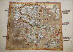
Decima Europe Tabula from Johann Reger edition of Ptolemy Geographia
Very rare map on trapezoid projections, from the edition of 1486 of the Geographia printed in Ulm.
In 1482 Lienhart Holle in Ulm published a revised edition of Ptolemy's Geographia with the reworking of the Ptolemaic corpus by the cartographer Nicolaus Germanus Donis. The atlas included five additional "modern" maps: Italy, Spain, France, Scandinavia, and the Holy Land. The atlas would be the first book printed by Lienhart Holle, however, it would appear that the venture proved ruinously expensive and his business would go bankrupt shortly after publication. The remaining sheets, the woodblocks and the types passed to Johann Reger in Ulm, who reissued the work in 1486.
As well as the modern maps the atlas bears some other notable first. It was the first time that maps were signed by the artist responsible for the woodcutting; in this case Johannes of Armsheim, who signed the world map, and incorporated a backwards N into the woodcut text on each map. It is also the first to print the accompanying text on the verso of the map to which it refers. Another important feature of the Ulm editions is the introduction of the publisher's colouring upon the maps. Maps from 1482 usually have a rich blue colour in the sea which was replaced with a soft brown colour in 1486.
The story of the Decima Europe Tabula is well told by George Tolias: “In Ptolemy's Geographia and the mappaemundi, in the maritime charts and the fifteenth-century humanistic Isolarii, Greece is present everywhere and nowhere. The territories inhabited and named by Greeks are regularly mentioned and sometimes even described in detail. Yet Greece does not emerge yet as a distinct regional entity. […] The reception of Ptolemy's Geographia in the West and its influence in shaping the modern worldview is a complex question of permanent interest to the historian, as it involves a wide range of key issues relating to the rational perception and mathematical representation of space, the definition of its regional structure and the exploration of its history. […] From as early as the fifteenth century, attempts were made to produce modern maps of various regions based on Ptolemy's system. Renaissance cartographers began to supplement the original corpus of ancient tabulae with modern regional maps, and Sebastiano Gentile has made an extensive study of how new maps were added to the Latin manuscripts of the Geographia. In 1466 Nicolaus Germanus began to produce manuscript couples of Ptolemy's treatise with an additional projection, as well as modern "Ptolemaic" maps of Spain, France, Italy, northern Europe and the Holy Land. This "updating" process reached a peak in the closing years of the fifteenth century, when Henricus Martellus Germanus produced his luxurious manuscript large-format edition in which the Ptolemaic tabulae of Europe and of the Mediterranean regions of Asia and Africa alternate with modern maps of the same regions. In this way Tabulae IX and X of Europe are followed by a modern map of the Balkan peninsula, which closely resembles those included in the isolarii of Henricus Martellus and the comparable map by Francesco Roselli” (cfr. George Tolias, Mapping Greece, p. 61).
Woodcut, a magnificent proof, printed on contemporary laid paper, in beautiful contemporary colouring, minimal restoration at center fold perfectly executed, otherwise in excellent condition.
Bibliografia
G. Tolias, Mapping Greece, n. 1233; Zacharakis, A Catalogue of Printed Maps of Greece, n. 2768.
Donnus Nicolaus GERMANUS (? - ante 1490)
|
Donnus Nicolaus Germanus is a path breaking cartographer of the medieval maps. One of the most important reasons for the popularity of Donnus Nicolaus is his Cosmographia, which is the first work of its kind. He also created two globes, which give a vivid description of the earth and the sky. The globes were created by him in the year 1477. These two globes predated the 'Erdapfel' by Martin Behaim. The two globes created by Donnus Nicolaus Germanus were preserved in Salle Pontifica or Magna Secreta, but they were lost in the Sacco di Roma in the year 1527. At the time of production of the globes, Donnus Nicolaus invented the 'Donis' map projection. In this map projection, the parallels of latitude are kept equidistant, while the meridians are made to converge towards both the poles.
|