| Reference: | S10130 |
| Author | Johannes JANSSONIUS |
| Year: | 1618 ca. |
| Zone: | Germany |
| Printed: | Antwerpen |
| Measures: | 490 x 390 mm |
| Reference: | S10130 |
| Author | Johannes JANSSONIUS |
| Year: | 1618 ca. |
| Zone: | Germany |
| Printed: | Antwerpen |
| Measures: | 490 x 390 mm |
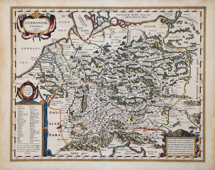
Beautifully colored copper engraved map of ancient Central Europe after Abraham Ortelius by Johannes Janssonius. Engraved by the famous Flemish engraver Pieter van den Keere. To the upper left a title cartouche, the lower left cartouche with places of uncertain location. The map, as his source, is dedicated in the lower left cartouche to Iacobus Monavius by Abraham Ortelius.
It shows the area from the North Sea and Baltic Sea in the north to south of the alps and the Adriatic Sea in the south. In the west is Holland and the mouth of the Rhine. In the east is the Weichsel river. The towns and cities from the time of Charles the Great (8-9 centuries) are in the legend in the lower left and especially marked on the map.
First edition, from Theatri Geographia Veteris by Petrus Bertius, Amsterdam 1618.
Copper engraving, fine later hand colour, in good condition.
|
cfr. M. Van den Broecke "Ortelius Atlas Maps" (2011), n. 200; Van der Krogt 1, 1:202.
|
Johannes JANSSONIUS (1588-1664)
|
Johannes Janssonius, more commonly known to us as Jan Jansson, was born in Arnhem where his father was a bookseller and publisher (Jan Janszoon the Elder). In 1612 he married the daughter of the cartographer and publisher Jodocus Hondius, and then set up in business in Amsterdam as a book publisher. In 1616 he published his first maps of France and Italy and from then onwards he produced a very large number of maps, perhaps not quite rivalling those of the Blaeu family but running a very close second in quantity and quality. From about 1630 to 1638 he was in partnership with his brother-in-law, Henricus Hondius, issuing further editions of the Mercator/Hondius atlases to which his name was added. On the death of Henricus he took over the business, expanding the atlas still further, until eventually he published an 11-volume Atlas Major on a scale similar to Blaeu's Atlas Major.
The first full edition of Jansson's English County Maps was published in 1646 but some years earlier he issued a number of British maps in the Mercator/Hondius/Jansson series of atlases (1636-44); the maps were printed from newly engraved plates and are different from the later 1646 issue and are now rarely seen (see Appendix B for further details).
In general appearance Jansson's maps are very similar to those of Blaeu and, in fact, were often copied from them, but they tend to be more flamboyant and, some think, more decorative.
After Jansson's death his heirs published a number of maps in an Atlas Contractus in 1666 and later still many of the plates of his British maps were acquired by Pieter Schenk and Gerard Valck, who published them again in 1683 as separate maps.
|
|
cfr. M. Van den Broecke "Ortelius Atlas Maps" (2011), n. 200; Van der Krogt 1, 1:202.
|
Johannes JANSSONIUS (1588-1664)
|
Johannes Janssonius, more commonly known to us as Jan Jansson, was born in Arnhem where his father was a bookseller and publisher (Jan Janszoon the Elder). In 1612 he married the daughter of the cartographer and publisher Jodocus Hondius, and then set up in business in Amsterdam as a book publisher. In 1616 he published his first maps of France and Italy and from then onwards he produced a very large number of maps, perhaps not quite rivalling those of the Blaeu family but running a very close second in quantity and quality. From about 1630 to 1638 he was in partnership with his brother-in-law, Henricus Hondius, issuing further editions of the Mercator/Hondius atlases to which his name was added. On the death of Henricus he took over the business, expanding the atlas still further, until eventually he published an 11-volume Atlas Major on a scale similar to Blaeu's Atlas Major.
The first full edition of Jansson's English County Maps was published in 1646 but some years earlier he issued a number of British maps in the Mercator/Hondius/Jansson series of atlases (1636-44); the maps were printed from newly engraved plates and are different from the later 1646 issue and are now rarely seen (see Appendix B for further details).
In general appearance Jansson's maps are very similar to those of Blaeu and, in fact, were often copied from them, but they tend to be more flamboyant and, some think, more decorative.
After Jansson's death his heirs published a number of maps in an Atlas Contractus in 1666 and later still many of the plates of his British maps were acquired by Pieter Schenk and Gerard Valck, who published them again in 1683 as separate maps.
|