| Reference: | S48504 |
| Author | Johannes JANSSONIUS |
| Year: | 1657 ca. |
| Zone: | Ferrara |
| Printed: | Amsterdam |
| Measures: | 455 x 365 mm |
| Reference: | S48504 |
| Author | Johannes JANSSONIUS |
| Year: | 1657 ca. |
| Zone: | Ferrara |
| Printed: | Amsterdam |
| Measures: | 455 x 365 mm |
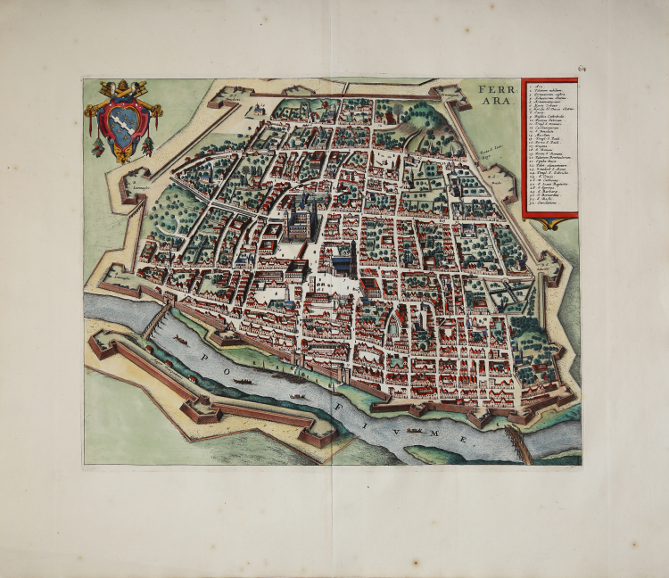
Pianta prospettica edita, per la prima volta, da Johannes Janssonius nel 1657 circa, qui nella ristampa di Frederick de Wit edita ad Amsterdam verso il 1680.
Viene pubblicata nella raccolta di Johannes Janssonius, Theatrum urbium Italiae aliarumque in insulis Maris Mediterraneae, Amsterdam s.d. (1657 circa), vol. V. Janssonius si propose di rinnovare il successo riscosso dalle Civitates orbis terrarum del Braun e riuscì ad acquistare in blocco la raccolta di rami dagli eredi dell'ultimo editore-incisore dell'opera di Colonia; eliminati quelli più deteriorati, ne aggiunse parecchi di nuovi, dando origine ad una splendida edizione ricca di tavole decorate da cartigli e cornici di gusto barocco, motivi cari all'autore che comprese le istanze del suo secolo e se ne fece portavoce. Alla fine del secolo Frederik de Wit, che già aveva al suo attivo edizioni di carte e di atlanti, venne in possesso dei rami pubblicati dallo Janssonius e preparò una nuova edizione intitolata Theatrum praecipuarum totius Europae urbium tam icono- graphice quam cospicue delineatarum, Amsterdam s.d. (1680 circa). La pianta non ha subito variazioni rispetto all'edizione di Janssonius, ma non reca il testo descrittivo al verso.
Acquaforte con magnifica coloritura a mano, in eccellente stato di conservazione.
Bibliografia
Alberghini, Ferrara, pag. 185 per la ristampa di Vander Aa del 1724.
Johannes JANSSONIUS (1588-1664)
|
Johannes Janssonius, more commonly known to us as Jan Jansson, was born in Arnhem where his father was a bookseller and publisher (Jan Janszoon the Elder). In 1612 he married the daughter of the cartographer and publisher Jodocus Hondius, and then set up in business in Amsterdam as a book publisher. In 1616 he published his first maps of France and Italy and from then onwards he produced a very large number of maps, perhaps not quite rivalling those of the Blaeu family but running a very close second in quantity and quality. From about 1630 to 1638 he was in partnership with his brother-in-law, Henricus Hondius, issuing further editions of the Mercator/Hondius atlases to which his name was added. On the death of Henricus he took over the business, expanding the atlas still further, until eventually he published an 11-volume Atlas Major on a scale similar to Blaeu's Atlas Major.
The first full edition of Jansson's English County Maps was published in 1646 but some years earlier he issued a number of British maps in the Mercator/Hondius/Jansson series of atlases (1636-44); the maps were printed from newly engraved plates and are different from the later 1646 issue and are now rarely seen (see Appendix B for further details).
In general appearance Jansson's maps are very similar to those of Blaeu and, in fact, were often copied from them, but they tend to be more flamboyant and, some think, more decorative.
After Jansson's death his heirs published a number of maps in an Atlas Contractus in 1666 and later still many of the plates of his British maps were acquired by Pieter Schenk and Gerard Valck, who published them again in 1683 as separate maps.
|