| Reference: | s34960 |
| Author | Henrick SCHERER |
| Year: | 1702 ca. |
| Zone: | Europe |
| Printed: | Munich |
| Measures: | 357 x 232 mm |
| Reference: | s34960 |
| Author | Henrick SCHERER |
| Year: | 1702 ca. |
| Zone: | Europe |
| Printed: | Munich |
| Measures: | 357 x 232 mm |
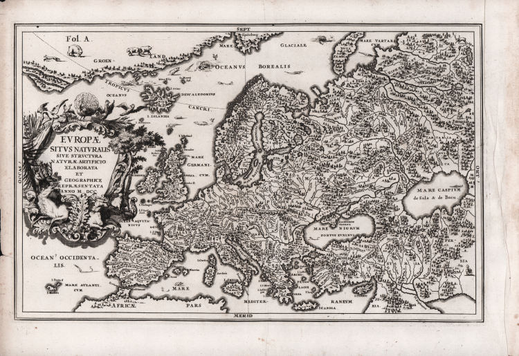
Lovely map of Europe featuring only geographical information of mountains, rivers and forests, by Heinrich Scherer (1628-1704) for his Atlas Novus exhibens orbem terraguem per naturae opera, historiae navae acveterus monumenta, artistique geographicae leges et praecepta...published in eight volumes from 1702-1710 in Munich.
Scherer, a devout Jesuit, produced this geographical compendium to depict the Catholic hierarchy and the spread of Jesuit missions throughout the world.
He produces maps that remove political boundaries, borders and place names, replacing them with the revolutionary concept for the period of showing the Mountains and forests in physical relief with all of the major waterways and rivers systems clearly depicted.
Scherer's Atlas forms an important milestone in the development of scientific and thematic cartography, providing a remarkable and revolutionary alternative vision of the World in showing only its major physical and topographical features.
The large, elaborate title cartouche is surrounded by wildlife, sea monsters abound in the seas, a bear and fox are shown in Greenland.
Copper engraving, in very good condition.
Henrick SCHERER (Dilingen 1628 - Monaco 1704)
|
Heinrich Scherer was a devout Jesuit, and professor of mathematics at Munich. His 'Atlas Novus' contained maps of all other parts which showed the spread of Catholicism and Jesuit missions.
|
Henrick SCHERER (Dilingen 1628 - Monaco 1704)
|
Heinrich Scherer was a devout Jesuit, and professor of mathematics at Munich. His 'Atlas Novus' contained maps of all other parts which showed the spread of Catholicism and Jesuit missions.
|