
| Reference: | MMS48B |
| Author | Maurille Antoine MOITHEY |
| Year: | 1785 |
| Zone: | Europe |
| Printed: | Paris |
| Measures: | 980 x 720 mm |
| Reference: | MMS48B |
| Author | Maurille Antoine MOITHEY |
| Year: | 1785 |
| Zone: | Europe |
| Printed: | Paris |
| Measures: | 980 x 720 mm |
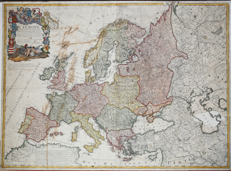
A fine and uncommon separately issued wall-map of all Europe extending east to include Armenia and western Russia.
The map which is attractively coloured has a large decorative title piece at top left surrounded by the coats of arms of major countries and supported by two cherubs examining a globe against a background of military implements.
Printed on two joined sheets, paper folds and tears perfectly repaired, otheriwise good condition. In full body colours.
|
Tooley, Mapmakers I, 314 u. III, 266
|
Maurille Antoine MOITHEY (Parigi, 1732-1810)
|
Maurille Antoine Moithey (1732 - 1810) was a French mathematician, cartographer, globemaker, game designer, and bookseller active in Paris in the mid to late 18th century. Moithey was born in Paris. He held the post of 'Ingénieur géographe du Roi' and professor of mathematics to the pages of the Prince and Princess of Conti. Throughout his long career as a geographer, he was an ardent spokesman for the 'freedom of the seas', particularly as applied to the English Channel.
|
|
Tooley, Mapmakers I, 314 u. III, 266
|
Maurille Antoine MOITHEY (Parigi, 1732-1810)
|
Maurille Antoine Moithey (1732 - 1810) was a French mathematician, cartographer, globemaker, game designer, and bookseller active in Paris in the mid to late 18th century. Moithey was born in Paris. He held the post of 'Ingénieur géographe du Roi' and professor of mathematics to the pages of the Prince and Princess of Conti. Throughout his long career as a geographer, he was an ardent spokesman for the 'freedom of the seas', particularly as applied to the English Channel.
|