| Reference: | S36770 |
| Author | Vincenzo CORONELLI |
| Year: | 1689 |
| Zone: | Crete |
| Printed: | Venice |
| Measures: | - x - mm |
| Reference: | S36770 |
| Author | Vincenzo CORONELLI |
| Year: | 1689 |
| Zone: | Crete |
| Printed: | Venice |
| Measures: | - x - mm |
PRIMA EDIZIONE
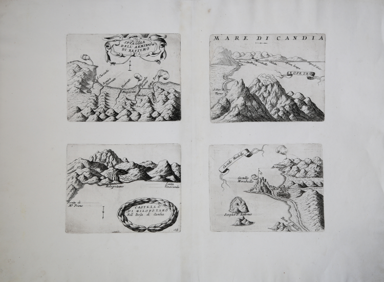
Esemplare tratto dal rarissimo Citta, Fortezze e, Isole, e Porti principali dell'Europa in Pianta et in Elevatione, Descritte, e Publicate Ad uso dell'Accademia Cosmografica degli Argonauti dal Padre Maestro Coronelli Lettore, e Cosmografo della Serenissima Republica di Venezia, edito a Venezia da Domenico Padovani nel 1689.
Coronelli visse un periodo di straordinaria fecondità editoriale a partire dal 1689, quando ebbe la cattedra di geografia presso l'Università alle Procuratie, con la pubblicazione, nel 1690, del primo volume dell'Atlante Veneto. In effetti sotto il nome di Atlante Veneto va tutta la raccolta di tredici opere composte nell'arco del decennio successivo, dall'Isolario allo Specchio del mare.
In realtà solo alcune di tali opere possono definirsi atlante, mentre altre, sono opere di compilazione o semplici raccolte di vedute e fortificazioni come questa rara raccolta.
Incisione in rame, magnifica prova, con pieni margini, in perfetto stato di conservazione. Four engravings of about 170x130mm.
Vincenzo CORONELLI (Venezia 1650 - 1718)
|
Cosmographer, geographer, biographer, encyclopedist, globe maker, inventor, expert of engeneering and hydraulics. Extraordinarily versatile mind and an extremely tireless man, he produced more than 140 pieces in different genres. At the age of 15, he entered the Franciscan Order, which he then guided as Gran Generale from 1699. He became famous as geographer and mathematician, awakening the interest in these subjects in Italy at the end of the XVII century. He travelled a lot, seeking for all that was new, and keeping a correspondance with the most important intellectuals of his time. In 1681 Louis XIV wanted him to go to France, to entrust him with the task of making two terraqueous globes (Marly Globes), with a diameter of 4 metres. Once he came back to Italy, in 1685, he became Cosmographer of the Venetian Republic, where he taught geography and founded the first geographic accademy, called The Argonauts Accademy. In his whole life he produced more that 500 maps; some of them can be found in his most famous works, such as the Venetian Atlas (1690), the Island Book of the Venetian Atlas (1696-97), the Book of Globes (1693). As far as his scientific method, he didn’t elaborate new cartographic systems, but followed the theories that were considered most popular and effective at his time, based on the Copernican system. The main characteristic of his charts is the high quantity of toponymic and historical information. In his most famous and dense work, the Venetian Atlas, we can find about 1100 plates, 200 of which are extremely technical and this is the reason why it is considered the first Italian atlas to describe and illustrate the whole world with charts and maps. It was published in 13 volumes, starting from 1690, and it took nearly ten years to finish it. It is divided in different parts, the most important are the Atlas itself, then the Island Book, the Corso Geografico and the Teatro delle città.
|