| Reference: | S38500 |
| Author | Anonimo |
| Year: | 1600 ca. |
| Zone: | Crete |
| Measures: | 395 x 290 mm |
| Reference: | S38500 |
| Author | Anonimo |
| Year: | 1600 ca. |
| Zone: | Crete |
| Measures: | 395 x 290 mm |
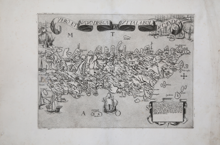
Very rare map of the island of Crete, without date and editorial indications.
This is an anonymous Italian map datable to the early years of the seventeenth century derived from the model of Giovanni Domenico Zorzi of 1538, and like this one shows the famous labyrinth of Knossos.
In the cartouche in the lower right corner reads: Creta Isola, volgarmente chiamata Cand[i]a da Candia Citta insigne: anticamente fu chiamata Cidone overo Cidonia. Quest’Isola è dotata quasi di tutti li beni per l’uso humano et è abondantissima, pretiosissimi vini. È situata in mezzo del mar pontico; La cui lunghezza è di 270 miglia; la laghezza di 50; et il circuito di 589; come si legge appresso Strabone Cosmografo, di cui questa fu la Patria.
The map is described by Zacharakis as "Italian C type, loose leaf map, measuring 38x28 cm, almost identical to the corresponding ones of Camocio and D. Bertelli, but under a different title and with the decorative addition of many sailing ships around the island" (cf. Zacharakis, De Situ Insulae Cretae, Four centuries of printed cartography of Crete, 1477-1800 (2004), p. 171).
For "type C" Zacharakis identifies the third model - in chronological order - of the maps of the island of Crete, the one compiled by Giovanni Domenico Zorzi and printed in Venice by Matteo Pagano in 1538 "The map of Crete published by the printing house of Matteo Pagano is attributed by the literature to the cartographer Giovanni Domenico Zorzi and represents the oldest map printed by the publisher. From the cartographic point of view the work seems to be a derivation, albeit with distortions in morphology, of the Tabula Neoterica Crete sive Candia Insula published in Strasbourg by Martin Waldsemuller in 1513. Remarkable details represented in the map, which has over 250 place names. It is the first map to represent the famous labyrinth of Knossos, depicted in the form of small concentric circles" (cf. S. Bifolco-F. Ronca, Cartografia e topografia italiana del XVI secolo, pp. 1496-97, table 714).
However, as Zacharakis rightly points out, this anonymous map seems to be a faithful replica of the map engraved by Paolo Forlani for the publisher Giovanni Francesco Camocio in 1564, which "constitutes one of the most widespread maps in the sixteenth-century cartographic collections; we have surveyed as many as 38 copies. The map had a second edition in 1584, edited by Donato Bertelli, with small differences in some place names and in the shape of the bays of Chania and Candia, and a third issue, anonymous, probably dating from the end of the sixteenth century" (see S. Bifolco-F. Ronca, Cartografia e topografia italiana del XVI secolo, pp. 1504-5, table 719).
Before today, I have only encountered this very rare work in the sixteenth-century factual collection of the Fondo Corsini, preserved in the Biblioteca Corsiniana in Rome [29.K.1]; a collection contained in a nineteenth-century volume. Being applied on a nineteenth-century support, I have not, therefore, been able to examine the paper against the light to verify the presence of a possible watermark; the impossibility of dating the paper had, although hesitant, induced me not to include the work in Cartografia e topografia italiana del XVI secolo (2018), considering it a product of the beginning of the following century.
Our example - previously in the famous collection of Fritz Hellwig - is printed on a laid paper that bears a watermark "anchor in the circle". This is a very common mark among Italian papers of the 16th century. David Woodward, in his study on watermarks found in Italian cartography of the sixteenth century identifies 24 different variants of this watermark, where the anchor in the circle is associated with other elements such as a star (of different sizes and workmanship), a clover, a four-leaf clover etc.. The oldest match is made on two maps dated 1538, one from Crete, the other from Cyprus, respectively printed by Giovanni Andrea Vavassore and Matteo Pagano in Venice. The most recent match on a map of Tivoli printed in Rome by Giovanni Antonio de Paoli in 1622. (see D. Woodward, Catalogue of watermarks in Italian printed maps ca. 1540-1600, Chicago, 1996, pp. 102-115, nos. 157-180).
Unfortunately, even the watermark does not help, therefore, to determine the date of the work, which Zacharakis does not even try to date (however, it is inserted before the 1570 map of Nicolò Nelli), probably in order not to make a mistake.
It remains, therefore, to rely on the initial impression, that it is a product at the earliest made at the end of the sixteenth century, more likely at the beginning of the seventeenth, from small Roman or Venetian topography, which did not have a great success.
Wonderful example, full margins, of this very rare map of Crete.
Bibliografia
Zacharakis, De Situ Insulae Cretae, Four centuries of printed cartography of Crete, 1477-1800 (2004), p. 171, n. 21; Zacharakis, The Mapping of Greece, (2009): p. 307, n. 3479/2776.
Anonimo
Anonimo