
| Reference: | MS6664 |
| Author | Dépôt des cartes et plans de la Marine |
| Year: | 1823 |
| Zone: | Corsica |
| Printed: | Paris |
| Measures: | 940 x 620 mm |
| Reference: | MS6664 |
| Author | Dépôt des cartes et plans de la Marine |
| Year: | 1823 |
| Zone: | Corsica |
| Printed: | Paris |
| Measures: | 940 x 620 mm |
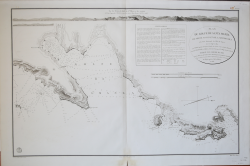
Lovely antique chart of the Gulf of Santa Manza, on the southeast coast of Corsica, France near the town of Bonifacio with numeous soundings and coastal topographic details. Beautifully executed and finely detailed engraving in near-perfect condition.
Noted features include: Port de Santa Manza, Iles de Porraja, Cap Capicciolo, Cap Blanc, Cap Rondinara, Port de la Rondinara, Calanque de Carlo Anto, Tour de Sponsaglia, Mt. Carpice, amd Porto Nuovo. At top, and extending the full width is a beautifully engraved view of the coastline that includes all the points above and many more.
This large, original copperplate nautical chart was issued by the French Depot de la Marine in 1823 and bears the circular stamp of that agency. Engraved by Ambroise Tardieu. With the circular stamp of three fleur-de-lis surrounding an anchor, from the Depot General de la Marine.
Dépôt des cartes et plans de la Marine
|
The Dépôt de la Marine, known more formally as the Dépôt des cartes et plans de la Marine, was the central charting institution of France. The centralization of hydrography in France began in earnest when Jean-Baptiste Colbert became First Minister of France in 1661. Under his watch, the first Royal School of Hydrography began operating, as did the first survey of France’s coasts (1670-1689). In 1680, Colbert consolidated various collections of charts and memoirs into a single assemblage, forming the core of sources for what would become the Dépôt.
The Dépôt itself began as the central deposit of charts for the French Navy. In 1720, the Navy consolidated its collection with those government materials covering the colonies, creating a single large repository of navigation. By 1737, the Dépôt was creating its own original charts and, from 1750, they participated in scientific expeditions to determine the accurate calculation of longitude.
In 1773, the Dépôt received a monopoly over the composition, production, and distribution of navigational materials, solidifying their place as the main producer of geographic knowledge in France. Dépôt-approved charts were distributed to official warehouses in port cities and sold by authorized merchants. The charts were of the highest quality, as many of France’s premier mapmakers worked at the Dépôt in the eighteenth century, including Philippe Bauche, Jacques-Nicolas Bellin, Rigobert Bonne, Jean Nicolas Buache, and Charles-François Beautemps-Beaupré.
The Dépôt continued to operate until 1886, when it became the Naval Hydrographic Service. In 1971, it changed names again, this time to the Naval and Oceanographic Service (SHOM). Although its name has changed, its purpose is largely the same, to provide high quality cartographic and scientific information to the France’s Navy and merchant marine.
|